Good Sunday, everyone. Major Hurricane Ida is ready to slam ashore along the Louisiana coast later today and this storm looks to bring problems all the way into Kentucky. Heavy rains will likely cause flooding issues around here from late Monday through Wednesday.
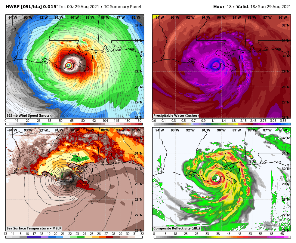
Let’s get into how Ida is looking right now in the Gulf. Quite frankly, this storm is a monster…

That’s a well defined storm and eye with the classic look of a devastating hurricane. This likely comes ashore this afternoon as a Cat 4 storm, but I can’t discount the possibility this makes it to Cat 5 status. The latest information and track from the NHC shows how Ida may still be a Tropical Depression when it arrives in Kentucky late Tuesday into Wednesday…

The latest Key Messages for Hurricane Ida from the NHC…
![[Key Messages]](https://www.nhc.noaa.gov/storm_graphics/AT09/refresh/AL092021_key_messages+png/213152_key_messages_sm.png)
Notice the final paragraph mentioning the flooding potential around here. I’ll get to that here in a bit.
Our exclusive interactive radar has everything you need to follow Ida into Louisiana. This is complete with live streaming cams from storm chasers in the line of fire…
So what about the impact this storm has on our weather? Here are a few thoughts:
- Ida may still be a Tropical Depression as it arrives in the region late Tuesday.
- The exact weather you get outside your house depends on the track of the low into Kentucky.
- Odds favor this low working from the Nashville area into southeastern Kentucky.
- The heaviest rains will fall north and west of the track of the low with a general 1″-4″ likely. Locally higher amounts will be possible.
- Wind gusts of 30mph or greater will also be possible as Ida works through.
- Ahead of the direct impact from Ida will be a front interacting with tropical moisture on Monday. This will bring some showers and storms that can put down a lot of rain.
- Flooding and flash flooding issues may develop across the region from late Monday-early Wednesday. The extent of this threat for any one location depends on exactly where Ida tracks.
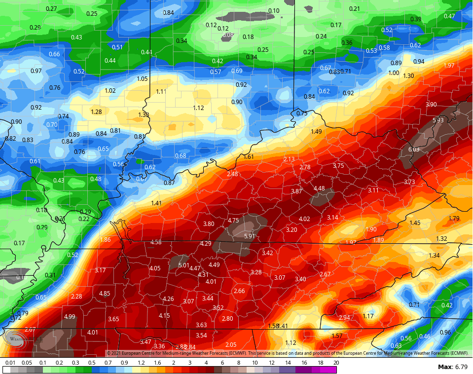
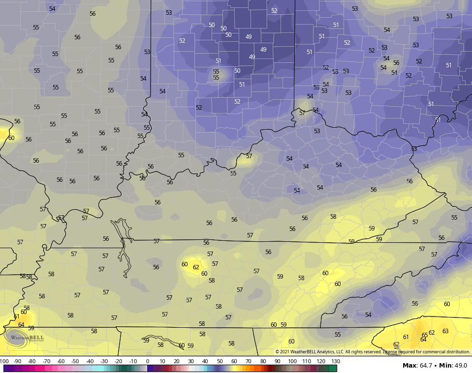
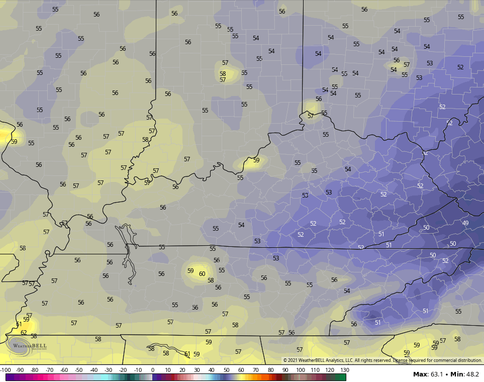
Let’s get a check of the latest model rainfall forecasts. Some of the models have focused just a little farther east compared to earlier runs, but jumps are common when dealing with systems like this.
EURO
NAM through Tuesday Night…
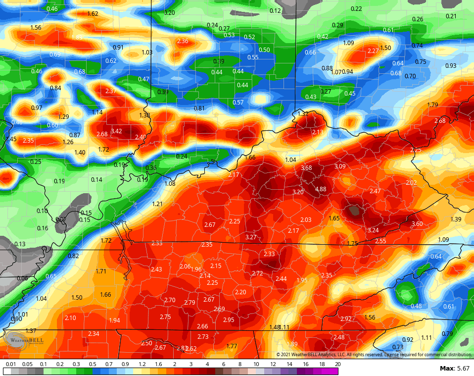
GFS
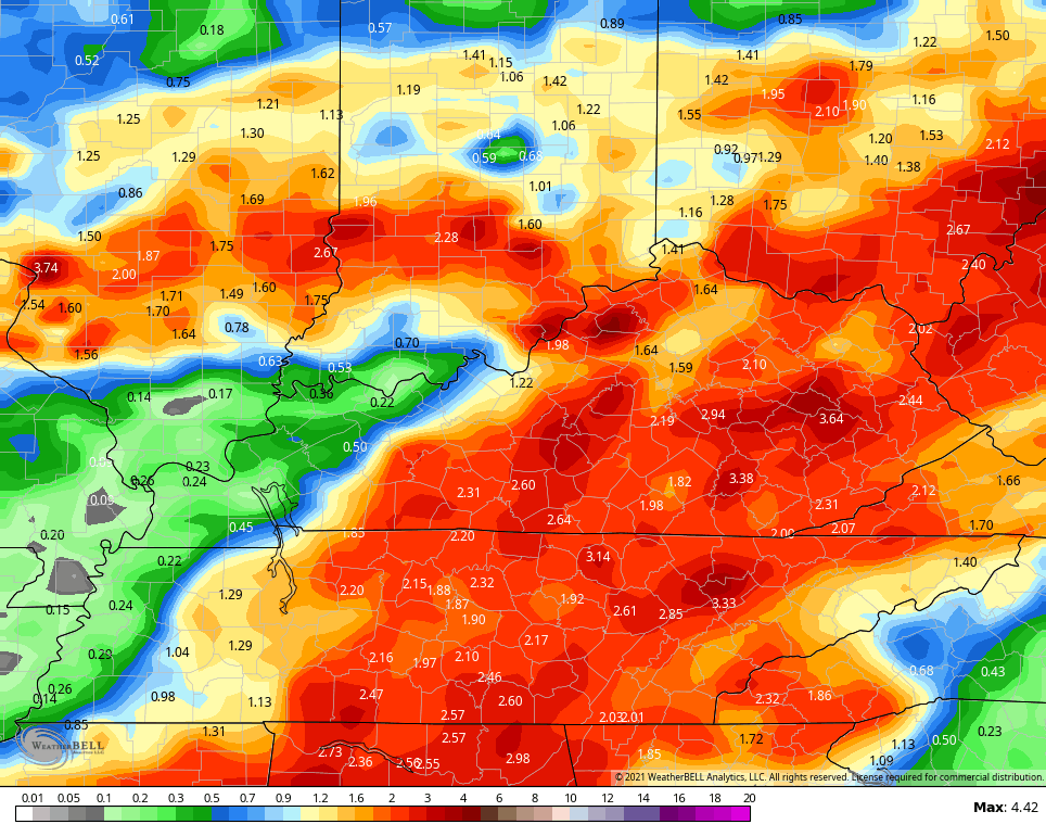
GFS Ensembles
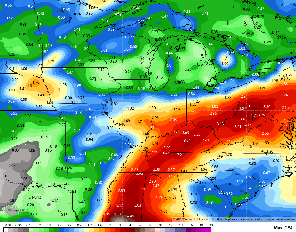
ICON
![]()
![]()
It’s interesting that the best hurricane model, the HWRF, is actually slower and farther west than the operational models from above…
Temps will be held way down as this system moves through and it will be able to pull in even cooler air once it departs. Check out the GFS lows behind it…
Thursday Morning
Friday Morning
A bigger blast of cool air is likely to show up around here just after Labor Day.
Another update of two comes your way later today, so check back.
In the short-term, a few showers and storms are going up on another toasty day in Kentucky. Here is your regional radar to track the action…

Have a great day and take care.

I am a$$uming that the HWRF is predicting that the stationary front in Indiana will be weaker than what the other models are forecasting.
The weaker the front is the more north IDA remnants can travel.
The only thing that matters is what happens in hours to come with Ida. Any predictions beyond that are a guess.
Looks like you’re sitting right in the bullseye for heavy rain.
Looks like the track of is a has move little bit to the east from were I live here at western ky. We shall see how this unfolds.
Hurricane Ida is now estimated to be a category 5 before making landfall somewhere along the Louisiana Coast this afternoon and then head inland towards the city of Baton Rogue. May everyone be safe !
In my opinion it is too early to make a prediction as to how much impact this storm will have on the state of Kentucky. Anyone here remember what Tropical Storm Ike brought to Kentucky ?
Spelling correction: Baton Rouge. I’m German and not French, but that is no excuse for spelling errors.
https://www.kentuckytoday.com/stories/hurricane-ike-remembered-on-10th-anniversary,15212