Good afternoon, folks. Powerful Hurricane Ida is slamming into Louisiana as a strong Cat 4 storm and the devastation it’s leaving is hard to comprehend. This storm will weaken as it moves our way, but it will bring the potential for flooding rains to much of Kentucky.
There isn’t much more I can say about the current state of Ida. This sat shot says it all…

Here’s our exclusive interactive radar, complete with live storm chase cams from Louisiana…
The latest NHC track forecast continues to bring Ida into southeastern Kentucky as a Tropical Depression…

The latest NHC Key Messages For Hurricane Ida continue to highlight the flood and flash flood threat in our region Tuesday and early Wednesday…
![[Key Messages]](https://www.nhc.noaa.gov/storm_graphics/AT09/refresh/AL092021_key_messages+png/213152_key_messages_sm.png)
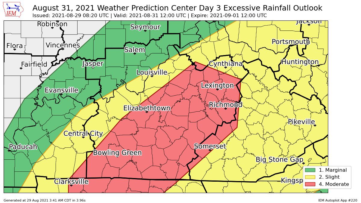
The Weather Prediction Center has a Moderate Risk for excessive rainfall across central Kentucky on Tuesday…
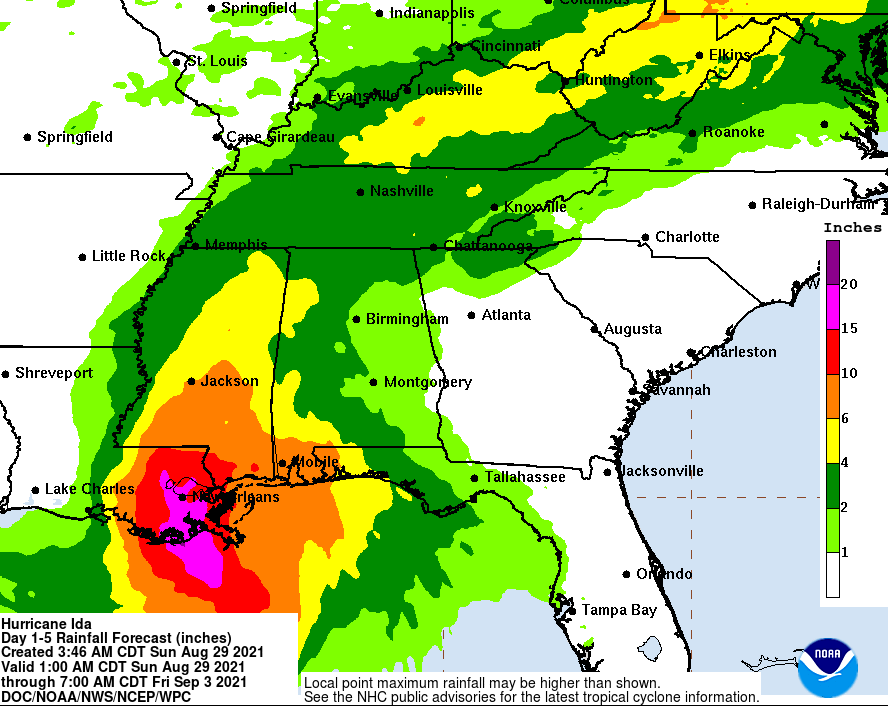
This is the latest rainfall forecast from the Weather Prediction Center…
The rainfall forecast from the EURO continues to be the most consistent…

Here are some fresh afternoon thoughts:
- We really need to watch the Monday afternoon and evening setup. A front drops in from the north and slows down. At the same time, deep tropical moisture is moving in well ahead of Ida. The combination of these two will likely spawn slow-moving, torrential rain producing showers and storms. Flash flooding issues are possible.
- Tropical Depression Ida arrives Tuesday from southwest to northeast. The center of circulation likely moves from near Nashville into southeastern Kentucky.
- The corridor of heaviest rain will likely fall along and northwest of the track of Ida.
- How much rain you get depends on exactly where the low tracks and the forward speed of the storm. The faster the movement, the lower the rain totals and vice versa. Right now, a general 1″-4″ of rain will be likely. A stripe of 4″+ rains will be possible.
- Flash flooding and some flooding will be possible as Ida moves through.
- Flash Flood Watches should go up from Monday afternoon through Wednesday morning.
- Wind gusts of 30mph or greater will be possible for parts of Kentucky.
The latest Hurricane Models are all tightly clustered in bringing what’s left of Ida across eastern and southeastern Kentucky late Tuesday…

Let’s take a look at two of the more reliable and detailed hurricane models. The HWRF continues to run on the western side of the guidance with where Ida goes in our region…

The HMON is just a bit east of that…

I will likely drop by with another update this evening, so check back.
We do have storms going up out there this afternoon and some can put down torrential rains and be on the strong side. I leave you with your regional radar…

Make it a good one and take care.

Thanks for the update.
Thanks Chris for keeping us updated on Hurricane Ida. Information coming out of Louisiana has been rather sketchy. I think through the week we will know more about what areas were most affected.
We had a tropical downpour this afternoon that lasted about 15 minutes. I don’t remember the trees looking so lush and green in late August. It looks more like late May after a rain. We are definitely in a subtropical weather cycle.
I’m ready for Autumn weather now as the days get shorter. I just hope Summer weather doesn’t hold on too late into our Autumn months.
Growing up on the New Jersey shore, and if the 60 that I’ve avidly followed hurricanes has taught me anything, it is that these monsters are unpredictable in the extreme. South Central Kentucky is likely to pick up significant rainfall from Ida, as well as from a slow moving front tapping into gulf moisture. We shall see…