Good Tuesday, everyone. We have a quick-hitting band of light snow rolling into parts of the region later tonight and early Monday. This may put down minor accumulations for some areas and we will take a closer look at that. But, the main story going forward is the potent storm system that looks to cause problems this weekend.
Tonight’s light snow system is just that… Light. We may very well have a couple of streaks of light snow with one across the northern half of the state and another in the southeast early Wednesday. you can see that on the new GFS…

That matches up well with my odds map from yesterday evening…

Again, this is mainly coatings on grassy and elevated surfaces, but some local half to 1″ amounts are possible I suppose.
Listen, this isn’t an everyone sees snow out of this so let’s not get carried away here. 😜
The next system is a much stronger one and likely to bring some wild weather. Here’s a breakdown of what to watch for over the weekend:
- Some scattered showers and storms may flare up ahead of the system on Friday.
- Southwest winds kick in Friday into early Saturday and that causes our temps to surge. Upper 60s and low 70s look common and we could set record highs.
- Rounds of heavy rain and thunderstorms then target the region Saturday and Saturday night.
- A few strong to severe storms will be possible once again.
- High winds of 40mph or greater will be possible regardless of severe storms.
- Flash flooding and general flooding are both possible over the weekend with the potential for river flooding to carry us into early next week. Many areas may see another 2″-4″ of rain with locally higher amounts.
- If you’re in a flood prone area, please stay alert to the latest forecasts in the coming days.
- Colder air crashes in Sunday with the potential for a period of wet snow as this system winds down.
Here’s how the GFS sees this playing out…

GFS Wind Gusts

GFS highest temps Friday/Saturday…

GFS Sunday Morning Wind Chill

Now THAT is a big time drop in under 24 hours.
The GFS Rainfall Forecast is hammering the east and southeast…
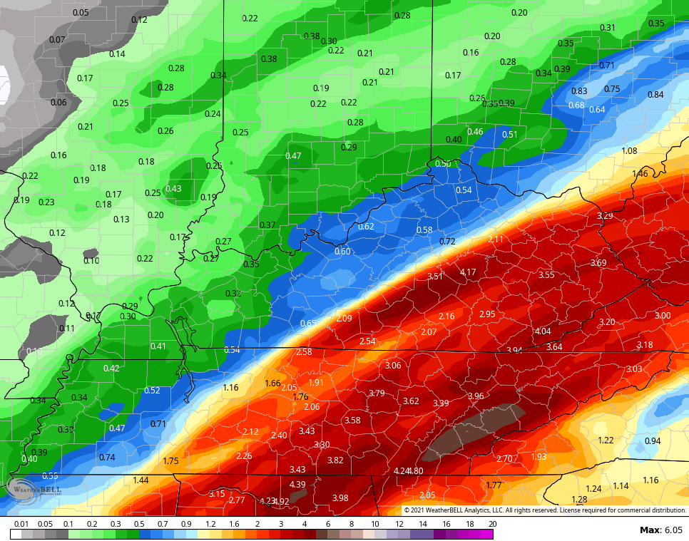
Here’s the area I’m highlighting for the potential for high water this weekend…

The pattern following this is likely to break milder once again into next week. This happens as the MJO continues through the warm Phase 6, but it’s forecast to head deep into Phase 7 just down the road…

The EURO extended is going through Phase 7 and even tries to get into Phase 8…

Phase 7 is much colder this time of year and Phase 8 is even colder than that…
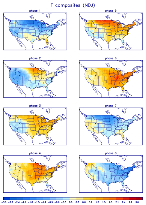
It’s pretty cool to look at where the pattern is now across the country and compare it to Phase 6 which we are in. Spot on! Get us into Phase 7 and 8 and let’s get winter rocking.
I will have updates later today so check back. Have a good one and take care.

Interesting Chris, but I can’t seem to grasp the MJO and how it relates to the other teleconnections. It’s probably a mathematical thing. One subject that is required to really understand meteorology.
Hope those areas you highlighted receive their first accumulating light Snowfall.
Here’s Chris’s Blog a year ago where he is discussing the MJO in more detail along with the other teleconnections, very interesting to me.
https://kyweathercenter.com/?p=45508
Here’s a good long read about just about everything..Also a forecast..
https://jimsullivanweather.com/2021/10/04/an-exploration-of-cool-enso-winters-and-a-look-at-winter-2021-22/
WOW !!! THANK YOU !. As all of you can tell I’m getting very obsessive when it comes to meteorology. I bookmark the article so I may refer to later. Thanks again, WxWatcher.
If it is not going to snow I prefer mild winter days.