Good Monday, everyone. Our new week is off and running on a milder note, but things look to turn very busy again before the week is over. That’s when the first in a series of systems will impact our weather with the potential for heavy rain and a few strong storms.
All this is the battle between different patterns. The one we’ve been in for much of December verses the much colder one we are about to go into. The slower that colder pattern is to arrive, the worse things can get around here in terms of too much rain and even more big thunderstorms.
Temps over the next few days take off and reach the 60s again for Tuesday and Wednesday, and this may hang into Thursday. That’s when our first front arrives with showers and thunderstorms, and some of those storms may be strong.
That front slows down just to our south as low pressure develops along it and lifts it back to the north. This looks like another round of heavy rain and storms.
Finally, a third system develops along this same front late Sunday into Monday. The track of the low is the deciding factor on whether we get in on more heavy rain and if we can see some winter weather out of it.
Here’s how the GFS looks with all three systems…

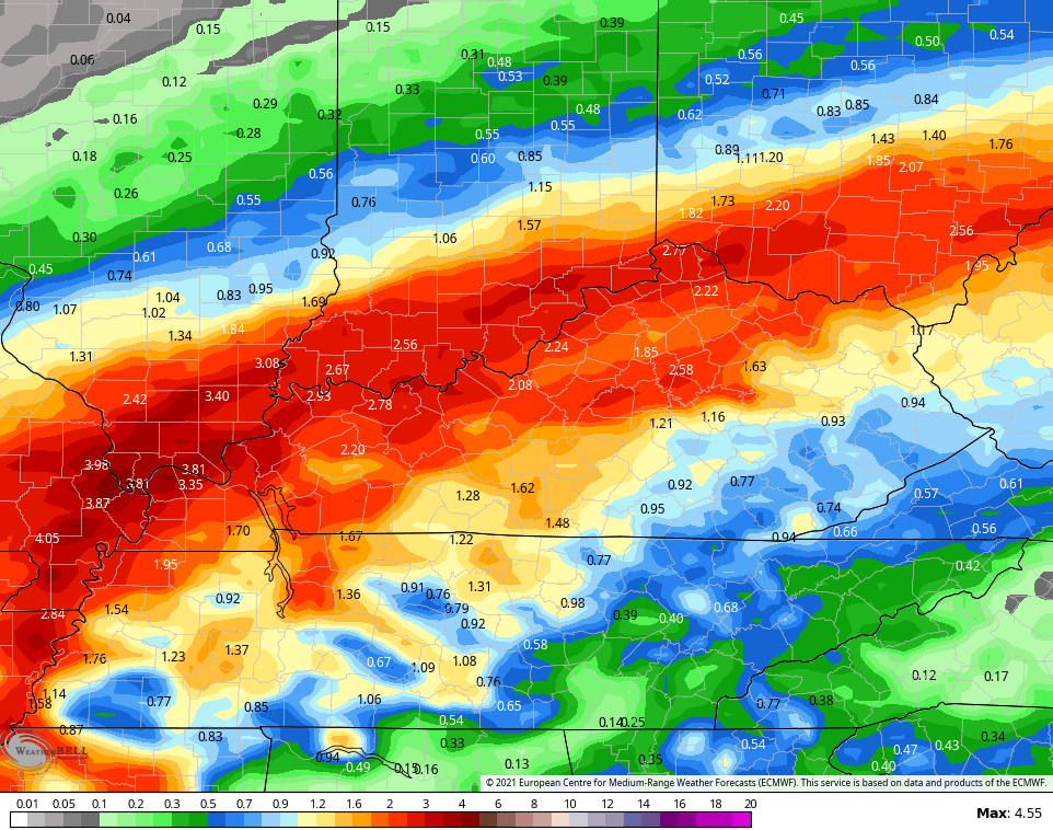
The rainfall forecast from this run of the model is rather alarming…

The Canadian is very similar, but has a little more of a snow look with the third system…

Here’s the rainfall forecast during this time…

The EURO only sees the first two because it leaves all the energy back in the southwest for the third system (a well known bias of the model)…

Even without the third system, the model still spits out a lot of rain…
Looking deeper into Christmas week, the GFS has some winter action…
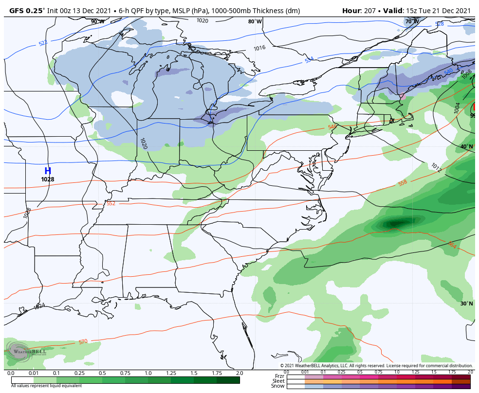
That’s part of the colder pattern finally beginning to flex some…

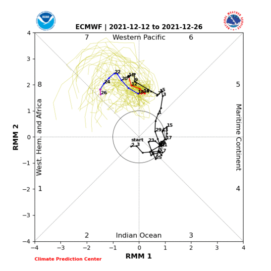
The signs of a pattern change continue to show up with our MJO signal. We continue to go from Phase 6 into Phase 7 and most models are also showing a gradual push into Phase 8…
GFS ENSEMBLES

EURO
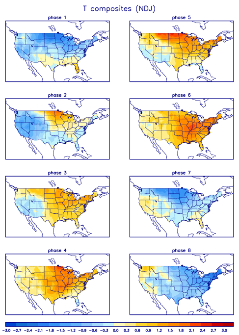
Phase 7 and 8 are much colder phases for this time of year. You can see that on the NDJ temp anomalies composites…
We are getting toward the end of December so we should also include those the DJF composites which start to soon take over…
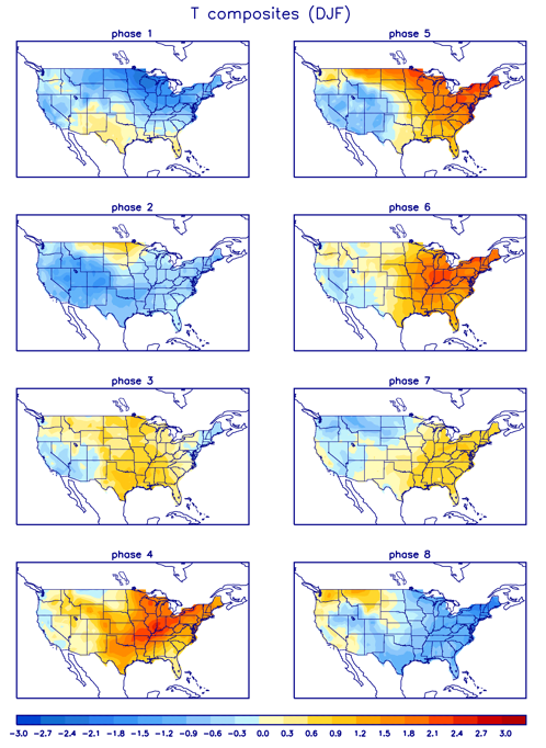
Notice how 7 is a little warmer during this time, but phases 8, 1 and 2 are very cold.
In addition to a more favorable MJO, other indices are also becoming more favorable. The models are forecasting a -NAO, -AO and -EPO to take shape in the next week or two.
I will have updates later today, so check back. Make it a good one and take care.

The destructive events of Dec. 11th caused us to lose power for a day, and internet access wasn’t restored until a few hours ago, so it’s great to finally catch up on KWC! We ended up with just a shower of small limbs and a couple of storm windows that came loose, bso we feel very fortunate indeed, as the tornado’s path missed us by about 2 miles. The devastation is incomprehensible, with the current death toll here in Bowling Green sitting at 11. The storm’s passage was terrifying, as you can see on the attached video clip…we watched as the local TV outlet’s weather cam showed this monstrous, wedge shaped storm approached the station.
https://www.facebook.com/100003448223429/posts/3499742720150634/?app=fbl
This weekend is one we forget for many years here in Bowling Green. My home was just two miles from the path of the tornado, but we escaped with only a shower of small limbs and a couple of storm windows that came loose. Remarkably, we lost power for only 12 hours, but we didn’t have internet service restored until a couple of hours ago, so it’s great to be able to hook up with KWC once more! The storms passage was terrifying… We huddled in our safe space, heard the “C.O.W.S.” sirens, felt the winds start to buffet the house, and what really raised the hair on the back of my neck was hearing the classic freight train sound. If we can’t get the sights and sounds of that night out of OUR heads, it’s almost impossible to imagine what those who lost their homes or loved ones were feeling.
Here is a short video clip of the twister as it approached the weather cam of a local TV outlet. Only afterwards did they realize that what filled the left hand side of the screen was the massive, wedge-shaped monster approaching the station! Moments after the video ended, we lost power.
https://www.facebook.com/100003448223429/posts/3499742720150634/?app=fbl
Test
JoeDfrom BG: That test, is it oral, essay or a nasty true-false?!
It’s nice to be able to check out KWC once again, our internet access was finally restored late last night. Still trying to come to grips with the large tornado that hit Bowling Green, killed 11 people, and missed my home by 2 miles.
Here is a short video clip of the twister as it approached the weather cam of a local TV outlet. Only afterwards did they realize that what filled the left hand side of the screen was the massive, wedge-shaped monster approaching the station! Moments after the video ended, we lost power.
https://www.facebook.com/100003448223429/posts/3499742720150634/?app=fbl
Here is the preliminary summary from the Paducah NWS of Friday evening’s long track, damaging tornado that struck Western Kentucky. https://weather.gov/pah/December-10th-11th-2021-Tornado