Good afternoon, everyone. It’s a nice start to the week and we keep that nice weather going for a few more days. Once we get into the second half of the week, things may turn pretty ugly once again. Rounds of heavy rain will target the region through the weekend and early next week, bringing an increased threat for flooding issues.
I’ve been focusing on this setup for a few days and now it’s getting my full attention. Here’s why:
- A cold front moves in Thursday with increasing showers and a few thunderstorms.
- That front gets to our south Friday as low pressure develops along it and rolls northeast.
- Heavy rain and some thunder then overspread the region in southwest to northeast fashion.
- That low goes by as colder air and drier air moves in on Sunday. This is only a brief stay of the dry air.
- Another storm system develops to our south and moves northeastward. This puts our region in another expanding precipitation shield for Monday.
- Rain develops during this time, but it’s a colder setup so we do run the risk of some snow out of this Monday night and early Tuesday as the storm moves away.
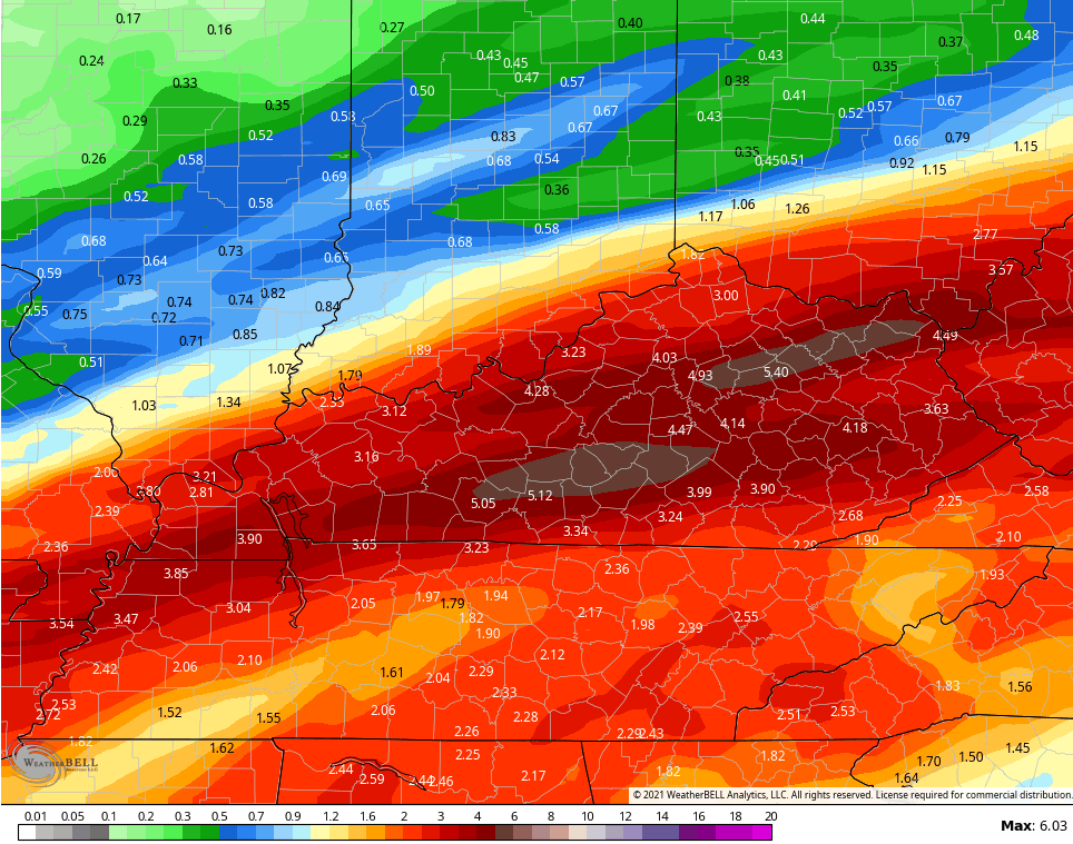
- Rainfall from Thursday through Monday will likely be in the 1″-3″ range with some pockets of 4″+ possible.
Here’s how the GFS is seeing the above scenario playing out…

Rainfall numbers during this time are very concerning…
The Canadian isn’t as hefty, but the numbers are still high…

The EURO cannot find this 3rd system and is struggling overall with so much energy coming out of the west. Here’s what it shows for rain through Saturday…

The signal toward colder is lost on the EURO because it can’t even handle the setup in the shorter range.
The Canadian Ensembles look similar to the GFS I shared last night with shots of cold showing up from Alaska across Canada and then aimed in our direction starting Christmas week…

Enjoy the rest of the day and take care.
