Good Wednesday to one and all. We continue to watch a very busy setup taking shape for the next several days. Rounds of heavy rain and thunderstorms may very well cause some issues through the start of the upcoming weekend. All of this starts with some serious wind gusts tonight and Thursday.
Milder air is pushing in here today as that strong southwesterly wind kicks in. There’s the chance for a shower ahead of this early today…

Winds are going to become a big player around here tonight and Thursday with gusts in excess of 40mph. This isn’t from thunderstorms, but it’s ahead of a massive storm system rolling from the plains to the Great Lakes. This system may have a swath of hurricane force wind gusts…

85mph gusts are showing up on that model into Iowa!! In addition to the gradient winds, there is now a MODERATE RISK for severe storms today for the upper midwest…

Think about that, folks. We are just over a week out from Christmas and there’s the chance for strong tornadoes in Iowa, Minnesota and Wisconsin. Let that sink in.
Our cold front moves in on Thursday with showers and thunderstorms sliding in from the northwest. That front then slows down with areas of low pressure developing along it and moving through here Friday into Saturday. The end result is a flood and flash flood threat.
Many areas will pick up a general 1″-3″ of rain during this time, but a swath of much higher amounts will be possible.
Here’s the area most at risk for the heaviest rains…

The NAM only goes through 7am Saturday, but the numbers from this run are staggering…

The GFS has had some runs like that over the past few days, so I can’t totally discount something like that happening. The current GFS is a little more spread out with the heavy rains…

Here’s the Canadian…
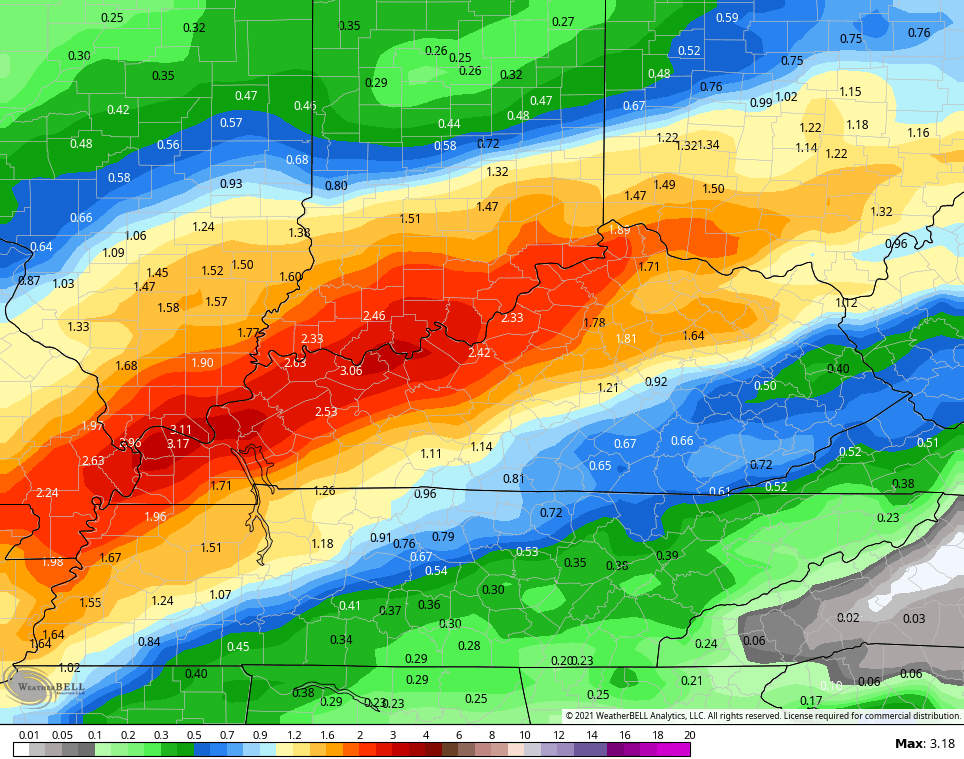
The EURO continues to be the most disjointed with the rainfall numbers…

The Christmas week pattern is all over the place on the models as we see cold air finally getting back into the country. With a ton of blocking showing up and the MJO going into a more favorable phase for winter weather, some massive switches will be showing up for a while.
We will talk more about that later today. Until then, have a good one and take care.

Good grief… that rain and wind on top of the damage and recovery efforts in WKY are going to be just terrible.
Praying the northern plains are spared, and that the wind and rain are not as heavy as predicted here in KY. We don’t need that kind of rain here in the east KY hills, either.
Schroeder, we’re all praying you’re okay. We miss you.
High Wind Warnings and Wind Advisories are in effect for the Chicago area from this evening through Thursday morning as Chicago is expected to break its record high of 64 for the date.
Thanks for caring all. It’s been a very trying week and I am tired. The F3 tornado was only a few miles from my home and I could here the roar early Saturday morning. Many homes were destroyed around Saloma in Taylor County, and we were without land-line phones and cell phones did not work.
I’m very sad about what happened in Mayfield, Kentucky and several other small towns in the surrounding area and my heart goes out for all those that were affected by this evil act of nature.
I don’t know what to think about this awful weather pattern which we seem to be stuck in. This is a very different La Nina and it seems to be driving Winter weather way North of our area into Canada. I’m hoping this will change and we will get back to colder weather soon.
Take care and pray.
Good to see that you’re okay.
I’m so glad you are okay, Schroeder. Thank God.
I am so relieved and happy to see you back on here Schroeder.