Good Thursday, everybody. With just over a week until Christmas, we continue to track a pattern of gusty winds and heavy rain. The heavy rainfall of the next few days may cause issues in some areas and that’s the focus of the short-term forecast. The longer term outlook continues to see colder air finally flexing on the pattern Christmas week.
Winds are the first thing to watch for today with gusts that may top 40mph at times. These gusty winds are ahead of a potent cold front dropping in from the northwest. This front is touching off a line of showers and thunderstorms that overspreads the state through the day. Here are your radars to follow along…

This front slows down across the Tennessee Valley tonight and Friday as a wave of low pressure moves along it. This brings additional rounds of showers and storms that will be around until another low finally takes the front to our east later Saturday.
Rainfall numbers will range from 1″-3″ with locally higher amounts. Keep a close eye on water levels, especially Friday.
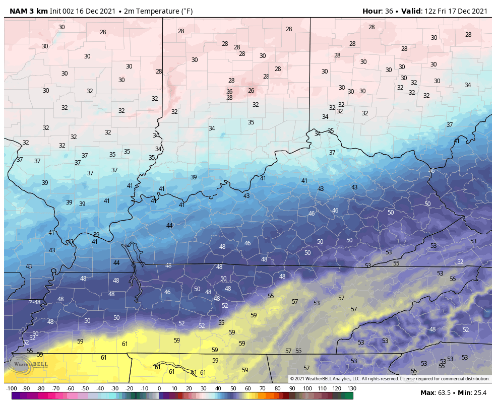
Temps are all over the place with this front on Friday. Look at this gradient showing up from 7am-11pm Friday…
Temps continue to climb Friday night into Saturday morning before crashing quickly. Here’s 7am Saturday through 7am Sunday…

Can we get a few flakes with that cold northwesterly flow late Saturday night and early Sunday? The Canadian thinks so…

So does the EURO…

It will feel the part of December finally for Sunday and Monday. The overall pattern for Christmas week is much colder than this week as we watch a couple of systems cross the country. Can we get one of them to deliver something for Christmas? The EURO has some rain and snow showing up…

We are now fully seeing the transition to winter finally taking place. The signals have been there, but it’s been a struggle to get the actual weather to respond. This is changing for Christmas week and that’s likely the beginning of a whole new setup.
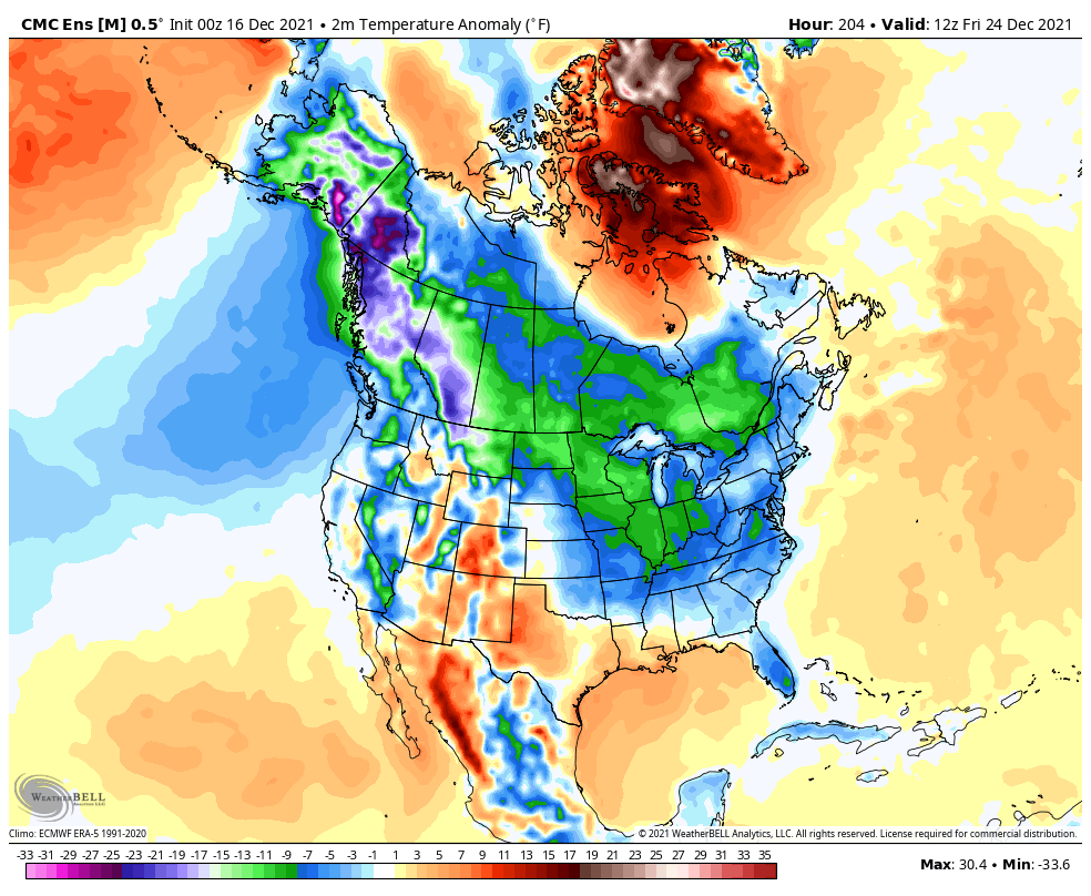
The Canadian Ensembles have been leading the charge on seeing the cold and continue to do so. Here’s the animation showing temperature departures from normal from Christmas Eve through New Year’s Eve…
The GFS Ensembles are starting to look the part…

I will update things later today so check back. Have a good one and take care.

Thanks Chris, I’m glad to be here on KWC after a very close call. With that all behind me, I am really ready for Winter to begin. I’m dreaming of a Snowy Christmas Day. Thanks everyone for all your kind caring words.
Hey Schroeder ……I kept looking daily to see if you’d comment. I was hoping the reason we hadn’t heard from you was communications outage….Glad you’re ok….when you don’t post on the forum, something is wrong. LOL
Good to see you’re safe and back in the fold, Schroeder!
Welcome back… I’m sure the tornado that hit near you caused some major power outages.
A lot of telegraph poles completely gone in the areas that got hit the hardest.
Weather history was made in the Chicago area both yesterday and today, as Chicago broke its all-time record high for both dates, reaching 66 degrees Wednesday and again shortly after midnight Thursday morning.
The winds were amazing! They were not caused by thunderstorms, but still gusted from 50 to 65 MPH last night and early this morning across the area. Chicago’s O’Hare Airport reported a 66 MPH wind gust late Wednesday evening.
Here is a complete summary from the NWS of the record warmth and strong winds across the Chicago area from yesterday and today: https://weather.gov/lot/2021dec1516
I don’t know about you guys, this weather is crazy. I hope Chris is right about the cold shots coming in so the atmosphere will settle down. The long term NOAA forecast is saying were staying on the warm side through out the winter. Time will tell.
Crazy weather will probably turn cold and we’ll have a major ice storm.
Dottie that’s the last thing we need.
Raining pretty steady at my neck of woods here in western,ky
Rain is falling at a good rate here too, but I’ll tell you all when that wind blows I get real nervous now after what happened early last Saturday.
I checked the Ventusky weather site and we are good on the (cape) maybe no severe weather for the rest of the year?
They are forecasting Arctic air to enter the US at the end of the year. Hope there is Snow included in that forecast ?
Ice Storms can form in La Nina Winters. We had one of the worse ones I’ve ever seen in January 2009.
The last thing the State of Kentucky needs !!!