Good Friday, everyone. A front has stalled across the region and will continue to fire up additional showers and storms through Saturday. That’s when a stronger system finally sweeps this system out of here as colder air comes in. This colder air looks to be the beginning of a colder pattern finally taking shape.
Waves of showers and a few storms come at us from southwest to northeast today into the evening and this is when some heavy rainfall numbers show up again. We have to be mindful about areas of western Kentucky that picked up more than 1″ of rain on Friday. These same areas may get in on 1″-2″ of rain today and that could cause local high water issues.
Here are today’s rain tracking toys…

Showers and storms will slowly lift north of the Ohio River tonight as another low enters into the region. That finally drags a cold front across the state Saturday with some additional action that tapers from west to east.
I’m using the HRRR rainfall forecast to illustrate the local high water potential, especially in western Kentucky…

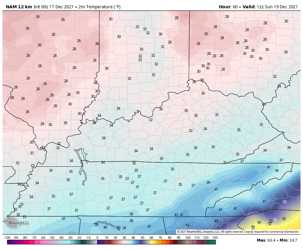
Temps are kinda crazy over the next few days and this starts out there today. Highs in the north are in the 40s with the south hitting the 60s. Those 60s lift northward overnight before the cold crashes in behind Saturday’s front. Check out this temp animation from 7pm this evening through 11pm Saturday…

Sunday is an honest to goodness December feeling day around here. Check out the numbers from 7am Sunday through 7am Monday…
The setup for Christmas week continues to trend much more seasonable with a few systems rolling eastward across the country. The models handle each of these differently. Here’s how the Canadian sees things through Christmas Weekend…

The EURO…

I will have updates later today. Have a good one and take care.

Thanks Chris, It’s a battle between the ridge in the Southeast and the Arctic air to our North. The Arctic air will eventually win the battle and I hope we have a lot of Snowy days down the old weather road to discuss on KWC.
well if you think back to a lot of winters…….a lot of them weren’t snowy or cold at all until the end of Dec……then turned very cold snowy…..but if the month of Dec is cold/snowy, Jan warms up….I’m not 100% sure, but a while back we were talking in the comments about 76/77 winter…..and I remember someone saying that that winter was totally warm until the new year and then it all went south with cold/snow. And remember a few years ago…..we had almost zero snow and then in Feb and March we had 2 record snows. We could end up with a warm winter throughout, or cold snow. No one knows at this point.
Right Mark, the Fall of 1976 was very mild with a lot of dry days and some wet days. About mid January 1977 the frigid Arctic air came and went all the way through Florida. Snowstorms begin to form in the Southern Rockies and moved East along the Subtropical Jet stream, which was sometimes referred to as the “El Nino Jet Stream.” According to my notes we had more Snow than we wanted and it didn’t let up until late March. Spring came in late April with a lot of plants damage in my nursery, but I recovered and made my nursery more protected from severe Cold and Snow and then we had 1977-78 Winter with the Blizzard. Those two back to back Winters are the ones I will never forget.
This Fall has been very much like 1976 except for the Tornado Outbreak. We will have to wait and see if all that frigid air in Siberia and Canada at the present decides to break loose and move way South ?
Schroedor, i agree those winters were brutal and something we haven’t experience since. They were long and very cold winters that we had something we are over due to have.
Winterlover, Yep, we are overdue for one of those Winters of the past. Being as old as I am now, I just hope it doesn’t get down below zero and stay there, but it can Snow all it wants LOL.
Me too Schroder!