Good afternoon, folks. We are heading into the super active pattern we’ve been talking about for a while. It’s one that has me concerned with way too much rain before Old Man Winter flexes some muscle finally as we begin the brand new year.
We have a front that hangs around the region for the week ahead and this allows for waves of low pressure to develop and roll across the region. Each of these will bring rounds of showers and thunderstorms our way…

Some areas may pick up 1″-3″ of rain through Thursday. Local high water issues can’t be ruled out to go along with very gusty winds.
This sets the stage for a major storm system to develop and roll across the region New Year’s Weekend. This system will be feeding upon a mega temp gradient as frigid air will be crashing in behind it and that may actually fuel a second system with winter weather.
The concern is for very heavy rains/flooding and the potential for some snow to follow.
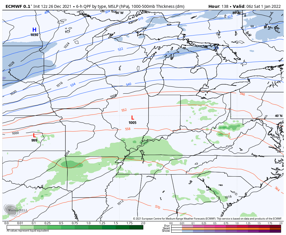
Here’s the current GFS…

The EURO has much more of a snow system to follow the big rains…
So does the Canadian…

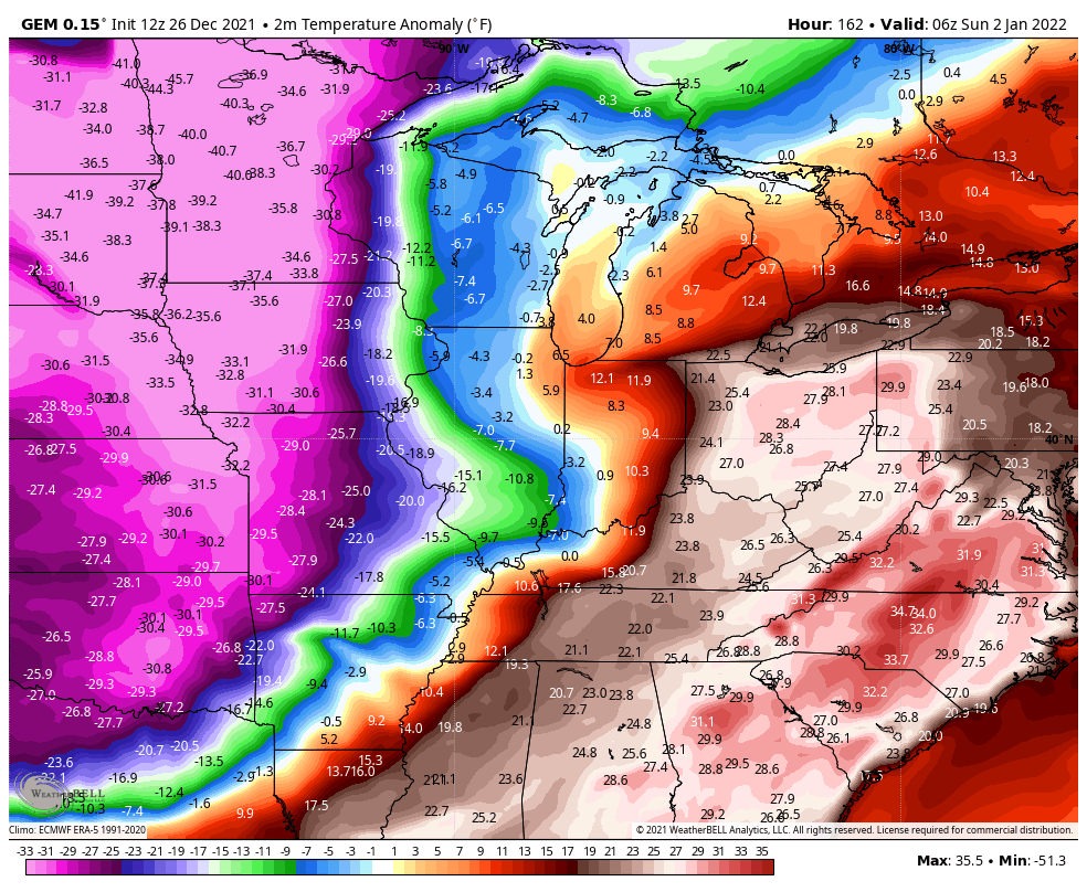
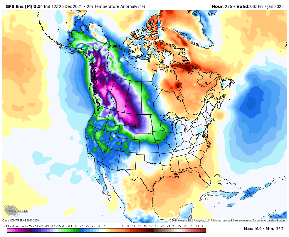
That’s some brutal air showing up on the Canadian. Check out these temp departures from normal…
The heavy rain potential is worrisome, and I am concerned about the flooding threat. Here are the numbers from the 7 day rain numbers from the GFS…

The EURO during the same time…

The Canadian…


I leave you with your radars to track any shower action that goes up…

Make it a great rest of your evening and take care.

Springtime weather, followed by flooding rains to Snow, followed by Arctic air. Some wild and crazy weather on the way. Hope the rains are not flooding and there is more Snow than rain and NOT ICE, and the temperatures stay in the teens and twenties.
On the latest model runs the predicted colder air for later in the month is not that cold and the light Snow predicted for my area of Kentucky is now gone. This would have been my first flakes of Snow for the Winter season, but there is plenty of time for such ?
On the other side of the country (Pacific Northwest) continues to be very Snowy. In fact, I checked out the area where we use to owned nursery property and that area has received well over four feet of Snow. I wish I was still there. This Springlike weather in December will probably hold through the rest of the Winter with short shots of colder air from time to time and unfortunately more Rain than Snow. UGH !!!
That strong ridge to our South and East is responsible for the record breaking high temperatures at the very beginning of Winter, and a moderate La Nina is almost always a Rain maker for the Ohio Valley. UGH again !!!
It seems like we have been waiting forever for the mythical cold air to reach the viewing area.
this was a busy post. Even with my fast internet it took forever for everything to load…..I think it’s the site because while I was waiting, I was browsing other sites with no issues.
I have been really doubting the cold air/snow possibility headed our way around the New Year, and I know we are still a week away…but we are getting closer & all of the models are still showing it, so I am starting to think it may be coming. It will be interesting to see what happens!