Good Monday to one and all. We’ve made it to the closing days of what has been a very extreme weather year across Kentucky. So, it’s fitting we send the year out with more wild stuff as rounds of showers and storms target the region. This will bring the potential for flooding before winter finally starts to show up after we flip the calendar to 2022.
The week is starting off with more mild air and a scattering of showers and storms. This action will show up from time to time, so keep the umbrellas handy. Here are your radars for the day…

This kicks off a very soggy pattern as rounds of showers and storms take control through Thursday. These showers and storms will be accompanied by very gusty winds and may put down enough rain to cause some local high water issues. Many areas pick up 1″-3″ of rain during this time.
Watch how these waves target the region during this time…
We catch a brief break for New Year’s Eve, but that changes shortly after the ball drops on 2022. This is when the overall pattern begins to change as bitterly cold air now across the northwestern part of the country starts to push farther south and east. This will fire up a potent storm system that rolls through our region on New Year’s Day with a colder system right behind it.
Here’s a breakdown of how this whole pattern breaks down through the coming weekend:
- Local high water issues will be possible through Thursday with 1″-3″ of rain possible.
- Wind gusts may top 40mph at times.
- Temps will generally be very mild, but some steep gradients may show up from north to south at times.
- More seasonable temps will be with us on New Year’s Eve with mostly dry weather.
- A deepening low pressure rolls across the region New Year’s Day into early Sunday. This brings heavy rain producing showers and thunderstorms with it.
- Most areas look to pick up another 1″-3″ of rain with locally higher amounts. This may lead to flooding or flash flooding.
- A few strong storms will be possible.
- Winds gusting to 40mph will also be possible.
- Cold air crashes in from the northwest on Sunday and this causes temps to tank very quickly.
- Another wave of low pressure may develop along the advancing front and this may have a swath of accumulating snow along and behind it.
- Frigid temps and wind chills will follow this up later Sunday into Monday.
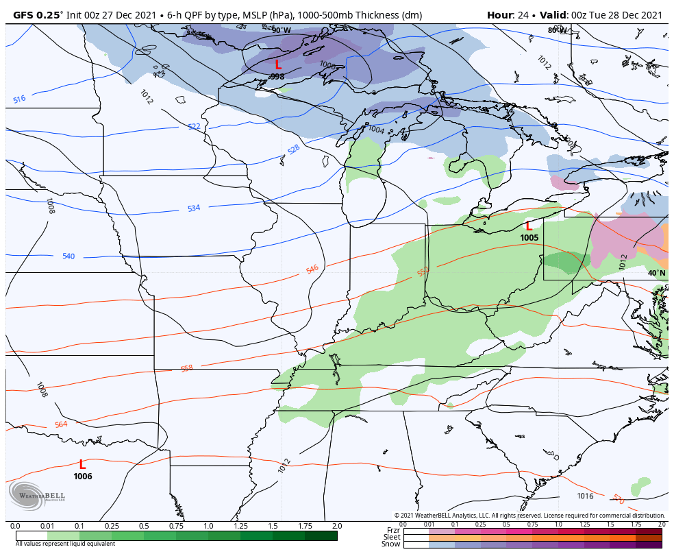
The GFS is fully on board with the above scenario…

The flood threat with the GFS is VERY high. Look at the amounts this run is spitting out…

The Canadian is similar…

Canadian rainfall numbers…

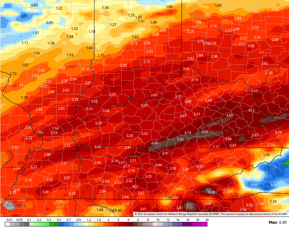
Here’s the EURO…

And the rain numbers from the EURO…
Temps may rebound a bit by the middle of next week, but that’s likely ahead of a colder push of air engulfing much of the country…

I will have another update later today. Have a great Monday and take care.

Thanks Chris, I’m hoping that your forecast along with the American and the Canadian weather models are something positive for all Snow Lovers. The European weather model has more Ice than Snow which would be horrible after what we have gone through this awful weather year.
Being in the agricultural/horticulture industry, I’m beginning to get concerned about all the plant life if this off and on extreme temperatures continue into February, March and April ?
It’s like life it’s very uncertain.
The computer models are no longer in agreement about a major snowstorm for the Chicago area this weekend. The GFS shows mostly rain, with the heavy snow to the north. The Canadian shows the rain/snow line moving closer to Chicago, while the Euro shows the heavy snow just to the south of the Chicago area.
Still lots of issues for all the computer models to sort out.
Yeah, that’s the way these weather models are behaving here lately. this morning the GFS had my area receiving one to two inches of Snow on the third of January. Will it happen ? Probably not with their records so far this young Winter season.
Schroeder, your horticultural concerns are well founded. Our ability to forecast weather today compared to 30 years ago should be vastly improved, especially when you consider the significant advances in meteorological and computer hardware, and ever more complex forecasting algorithms. But to put it in very simplistic terms, these algorithms are designed to expect parameters that reflect a more stable atmosphere. In years past, orecast algorithms that their core a more “predictable” baseline
our ability to accurately forecast weather
That last part should have stated: Forecast algorithms in years past have had to deal with extreme or abnormal conditions from time to time, but these days, the extremes have become the norm, causing some forecasting routines to have more pronounced biases. Throwing more computer horsepower at it won’t solve the problem, and in some cases, they could increase it. Forecasters at Penn State’s State College PA campus have been working on new algorithms that take the extremes that climate change has introduced into consideration, but their success remains to be seen. Forecasts beyond 7 to 10 days, in my humble opinion, are more likely to rely on professional intuition!
My phone glitched out on the last few sentences, and the program rejects my corrections as “duplications!”
SMH…
NOAA so far has been correct on their long range weather forecasting. Warm and Wet for the Ohio Valley and they also predicted that La Nina would serve a second term through the Winter and gradually phase close to neutral as we approach the Spring Equinox. To my knowledge, I don’t think there has ever been three consecutive La Nina’s, but the way the overall climate is behaving it wouldn’t surprise me.
I projected NOAA’s long range outlook for Dec. Jan. Feb. 2022-23 and it showed Alaska with above normal temperatures. That is a signal for a change in the PDO to positive which would indicate the emergence of ENSO.
I gotta agree with JoeD, mother nature has it tricks that human or a computer can’t predict what kind of weather will unfold down the road. I really think back in my younger days in the 60s and 70s before technology took over when weatherman would use a board and a blackmarker that they had more accurate weather forecast
Marcia Yockey, When she said it was going to Snow it Snowed and Snowed “buckets.” That brings back very fond memories. I really believe that she got me interested in meteorology after the record Snowstorm back in March 1960. I was only 9 years old.