Good Tuesday to one and all. It’s a very active setup that ramps up in the coming days and it’s likely to cause some issues. We have everything from the potential of strong storms and flooding to snow in the forecast as we get ready to end 2021 and start 2022.
Let’s begin with what’s happening out there today. Winds are very gusty with temps in the 60s for many once again.
A few showers and storms are working across the region as a boundary oscillates south-north across the state. Here are your radars to track the action…

A wave of low pressure works along this boundary later Wednesday into Wednesday night. This causes an increase in showers and storms moving from southwest to northeast across the region and some of these storms may even be strong or severe in the south. The Storm Prediction Center has a low-end risk for severe weather in these areas…

The damaging wind threat is the main player with those storms.
This same area may also pick up on a lot of rain in a short amount of time. This could cause some, at least, local high water issues to develop. Here’s the area I’m focusing on…

This sets the stage for a wild looking weekend as a stronger system rolls through here on New Year’s Day. This brings more rounds of heavy rain and the threat for strong storms as temps flirt with record highs again. We have to be on guard for some flooding issues during this time.
Another low then develops behind this and may bring some snow with it Sunday into Sunday night as temps crash.
As you would expect, we are getting the usual model variations from run to run. Here’s the current GFS…
The rainfall totals from the GFS are alarming across the southeast…

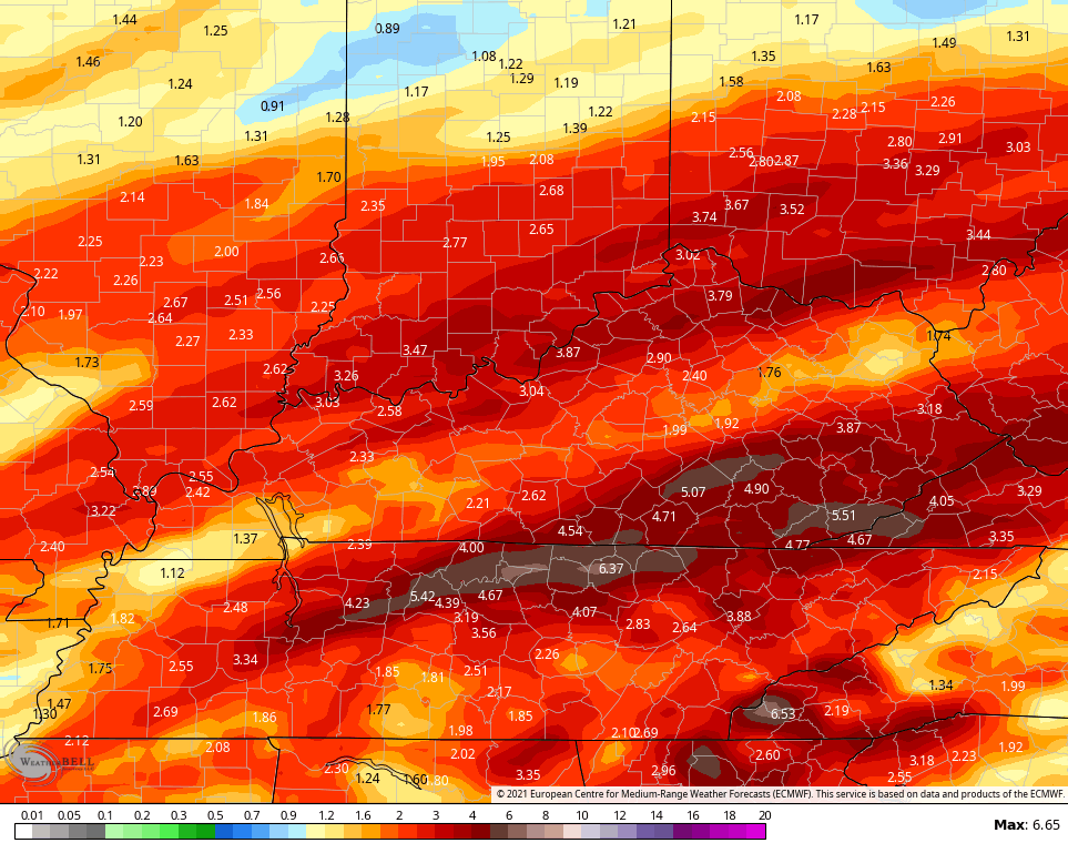
Here’s the latest EURO…

The rainfall isn’t as high as the GFS, but it’s still way up there…
The Canadian is the lightest of them all as the model has much more of a strung out look with the lows…

Temps behind this should rebound fairly quickly by the middle of next week and that will likely be ahead of another big system and possible true arctic cold front.
The Ensembles continue to show a VERY cold look for much of the country…
CANADIAN

GFS

I will have updates later today, so check back. Make it a good one and take care.

Snow potential looks greater in the east.
Western Kentucky invariably gets the short end of the stick.
Meanwhile, this crazy stretch of warmth has caused some of my Day Lily plants to send up sprouts! This Sunday’s forecasted high in Bowling Green is 66°, while the forecasted low on Sunday is 20°!
According to the various models we will continue this awful Winter here in the East for at least the next 10 days.
It doesn’t surprise me Joe that your Day Lilies are breaking dormancy. Next, it will be the Daffodils followed by Red Maple trees and so on…….
As the days get longer and warmer and wetter more dormancy will break and any Spring freezes will cause much damage to the Agriculture/ Horticultural Industry. Thanks to this second year La Nina.
As far as getting any accumulating Snow in our area of Western Kentucky/ South central Kentucky we still have a long wait ? In my opinion I don’t think we will have Snow on the ground until there is a drastic change in the Tropical Pacific Ocean ? Sorry for the very negative comment, but this is what I found out over the years of studding Meteorology and Agriculture.
Still uncanny how the models for KY tend to almost always show more snow early on, and then reduce once more actual weather data is available. Sadly they tend to get non snow related weather pretty spot on- including ice.
IllinoisMike, I see you finally getting the first measurement snow today. Hopefully next week we may get ours first one.
Yeah, it’s actually snowing at a pretty good rate, and it’s starting to accumulate on the ground. Winter Weather Advisories are in effect for the Chicago Metro Area along and north of I-80, with 1 to as much as 3 inches predicted, mainly on gra-s-s-y areas. The temps are around 32-33 degrees, so there probably won’t be much of an accumulation on pavement.
Temps are predicted to reach the upper 30s later this afternoon as the snow ends around 2-3 PM, so whatever accumulates will likely melt.
Still lots of questions about the weekend winter storm potential for the Chicago area, but at least we are finally getting our first measurable snow of the season today.
Mike, there is a number of storms forming along the West Coast and the interesting aspect of these storms is the phasing between the Polar Jet and the Subtropical Jet, I will be following the track as these storms evolve. Your area maybe in for a number of great Snowstorms ?
Record breaking -PNA pretty much killed December..Trough extended to Baja not gonna get it done..If not for the stout -NAO we may have hit 80 degrees or higher..Sure don’t seem like a La Niña..Don’t believe the West coast suppose to get big snow’s in a La Niña..Who knows in this ever changing climate.
I found out more negativity for Snow Lovers, but I’m not going to post any details. I’ve said enough. Please don’t get depress over the weather. Weather is ever changing. That’s what make it such an interesting study.
I agree Schroeder, Meteorology is very fascinating, When the Tornados of 1974 and blizzard of 1978 occurred I was hooked. The PNA has been a killer so far this short winter season and the NAO, and other telecommunications dont seem to show any signs of movement toward significant snowy weather anytime soon. Heck the MJO seems to want to try to loop in zone 7 back towards 6 in some models. with this ever changing climate the teleconnections of old may not mirror past outcomes like the past
After a jaunt to the mailbox I spotted 3 dandelions in yellow bloom on the lawn. Hope everyone has a great day!!
Looking at the Snowy Winter of 1917-18 ( a La Nina year) the NAO was negative and off the chart. Comparing then and now would make a good project for a meteorology student.
n
as a spring and summer lover, i do love the warmth. but id rather have the cold now instead of a cold spring that harms the vegetation. if this keeps up ill have to mow my lawn. i have patches of grass that could use a good trim. feels like march/april outside.
In the meantime I’m watching the potential for another outbreak of severe weather. This is something to keep an eye on as we enter new year. I hope it doesn’t happen ?