Good afternoon, folks. Scattered showers and storms continue to rumble across the region as a cold front hangs around. This boundary will be the focus of more showers and storms over the next few days and there’s the potential for some stronger storms. Think of this as the opening act to the system arriving this weekend.
Temps today are climbing from south to north as this boundary lifts northward. Scattered showers and thunderstorms will be noted as a strong southwest wind kicks in. Here are your radars…

An area of low pressure works in from the southwest along the front later Wednesday. This will bring severe storms to areas of the Tennessee Valley and a few of those may get into the southern half of the state. The Storm Prediction Center has a low-end risk for severe storms in this area…

Things calm down a little for Thursday into the final day of the year on Friday. Showers will increase Friday night as a potent low develops to our southwest and rolls into the region on New Year’s Day. This will likely bring very mild air in here and that air looks to be pretty unstable, leading to the potential for strong storms. The Storm Prediction Center as areas of southern Kentucky in the risk area alread…

Rounds of heavy rain are likely with this and that may cause high water issues.
Behind this low comes much colder air crashing in as a cold front sweeps through. A wave of low pressure should develop along this front on Sunday and that may bring some snow to the region.
The latest GFS is likely too far south with everything…

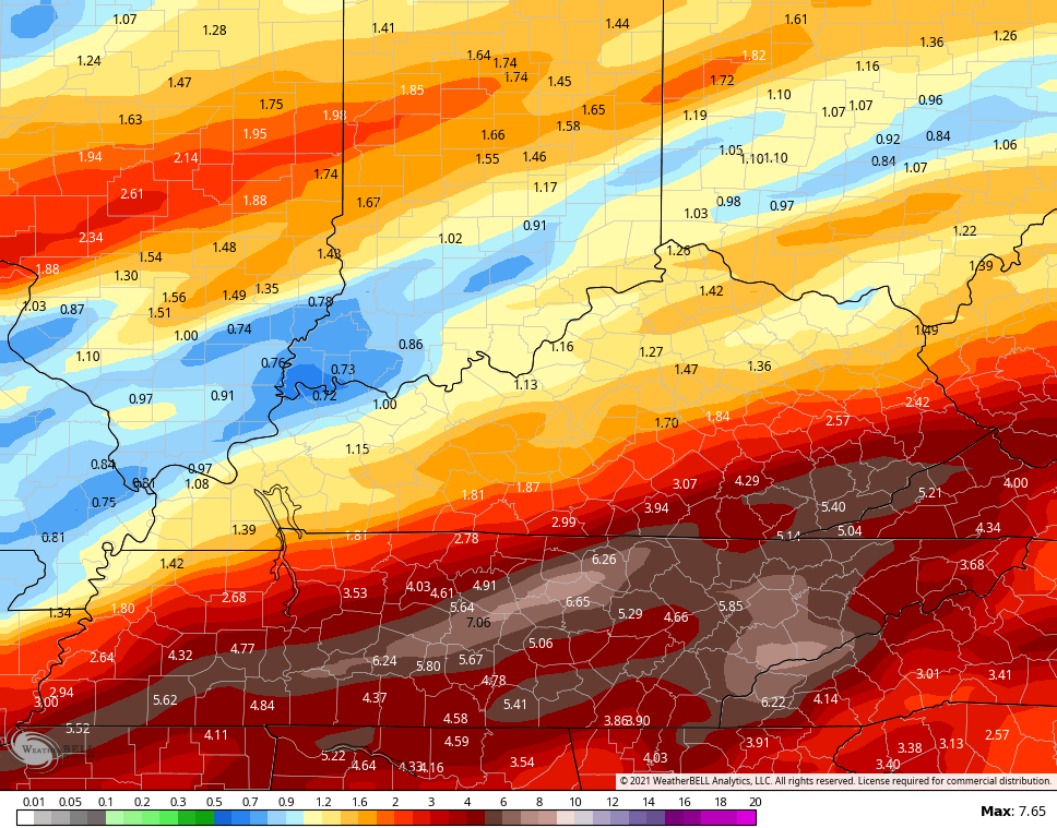
Here’s the rainfall forecast through Sunday…
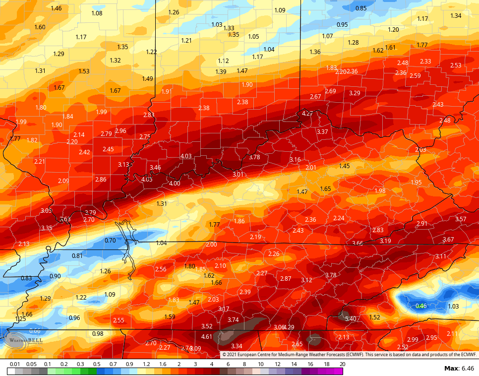
Here’s how the Canadian Model sees this…


The EURO seems to be having some convective feedback issues…

The ICON has this corridor of heavy rain that matches up with the models of the past few days…
![]()
![]()
Cold air crashes in behind all this. We may go from record highs near 70 on Saturday to temps in the upper 20s and low 30s Sunday. Here’s the EURO temp animation from 7pm Saturday through 7am Monday…

The Canadian is crazy cold and likely overdone…

Temps will rebound by the middle of the week, but it’s full steam ahead toward an arctic front crossing the country. That shows up well on the EURO…

That’s actually an interesting look as a frigid pattern develops for much of the country.
I’ve talked a lot about the 1984 analog being a strong one for this winter and here’s more proof…
67 degree right now in Lexington and that ties the record high for the date from 1984. #kywx
— Chris Bailey (@Kentuckyweather) December 28, 2021
Enjoy the rest of the day and take care.

Thanks Chris, I’ll be keeping a close watch on the possibility of severe weather over the next few days. Those Tornadoes that devastated a large area of Kentucky literally frighten me to no end. I don’t think I will ever get over it.
Can’t wait until that Arctic front clears the area. I don’t think we will get that much Snow in my area, but just
some Snow showers would be welcome ( our first flakes.)
It’s been a tough year for a lot of people and I pray and hope that next year Everyone will be Healthy and Happy as things get back to normal.
I pray you and the rest of Ky stay safe as we head into January, Schroeder. Here’s hoping for some real winter before the sun angle gets too high to sustain it for any length of time.
O’Hare Airport received 1.5 inches of snow this afternoon, while the NWS Forecast Office in the SW Suburbs received 2.3 inches.
Not bad for our first measurable snow of the season, but temps are now above freezing at 34 degrees with the snow beginning to melt. Dense fog is a concern for later tonight.
Thanks, Chris, for the updates. I keep hoping for a post that talks about a prolonged blast of cold, but so far we seem to be stuck in La Niña land indefinitely.
We had a high of 71 at my house in east KY today. It is still 69 degrees at almost 11p.
Please, let winter come soon. The potential for severe weather and flooding is concerning.