Good Thursday, folks. We have a big time storm system set to bring some wild weather across Kentucky as we close out 2021 and usher in 2022. Everything from strong storms and flooding to the first light snowfall of the season are on the weekend weather menu.
Let us begin with what’s going on out there today before we get to the weekend.
Temps are cooler than recent days, but we see a mix of sun and clouds taking over by the afternoon. Much of the day is dry, but a shower or two can’t be ruled out, especially early on. Here are your radars to follow anything that goes up…

Milder winds will quickly kick in tonight and early Friday and that may bring some scattered showers and storms back in here. Temps on New Year’s Eve rebound deep into the 60s and may be in the 60s at the clock strikes 2022.
Rounds of thunderstorms will also develop and rumble in here on New Year’s Eve and the stage is set for some of these to be strong or severe, especially across the west and south. The Storm Prediction Center has much of the are in a Marginal to Slight Risk for severe storms late Friday…

From there, the severe weather threat continues into New Year’s Day. Once again, we find the greatest potential across areas of southern Kentucky. Here’s the New Year’s Day risk area from the SPC…

I suspect the worst of the severe weather is just to our south, but we have to keep a close eye on this.
In addition to the severe threat, heavy amounts of rain will likely fall during this time and the models continue to spit out some impressive totals, but vary on placement…
EURO

GFS
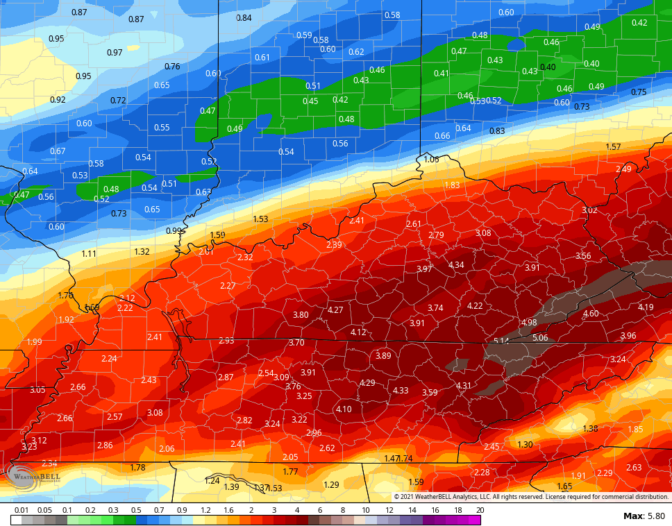
CANADIAN

MUCH colder air crashes in behind this from west to east Saturday night into Sunday. This will lead to, at least, a period of light snow across the region. Even though this is just a few days away, the extent of this potential varies on the models.
The GFS has a secondary low developing leading to a more substantial snow threat…
 The EURO is trying to develop this same system…

The Canadian also has the second low idea, but it’s farther south and a bit weaker…

Temps are very cold during this time and, if there’s snow on the ground, it could get pretty darn cold.
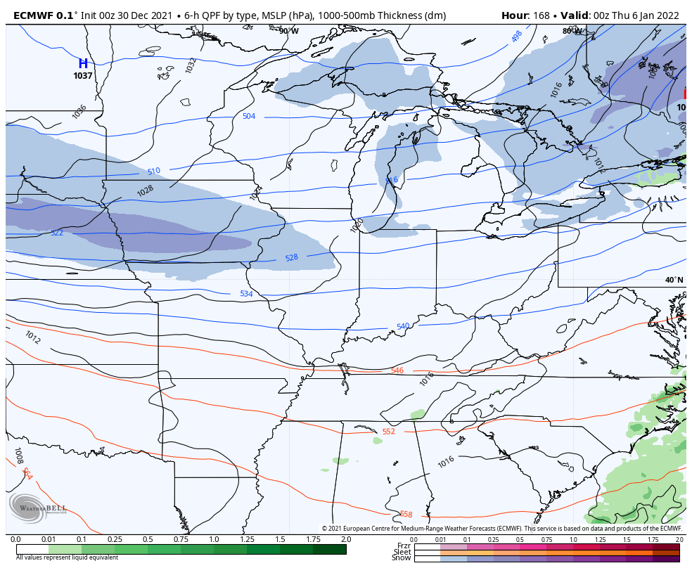
The numbers moderate quickly for a few days ahead of the next system moving in later in the week. This is essentially an arctic front with a wave of low pressure trying to develop along it. Here’s the GFS…

The EURO has a more pronounced system…
This is all part of a cold pattern that continues to flex on more and more of the country…

I will have updates later today, so check back. Make it a good one and take care.

Thanks Chris, I read the threat for severe weather for my area has lessen somewhat, but it could happen. Just what I need more uncertainty. I learned a lot about what’s going on with the overall pattern. I will mention one weather controlling factor: a very strong and persistent ridge that covers an area from the Caribbean to the western Gulf of Mexico northward to Michigan and east to the mid Atlantic and on to the Northeast. The high pressure weakens from time to time, but rebuilds keeping our normal Winter weather out of the Ohio Valley, but gives us Spring like weather and unfortunately an early start to severe weather season. A change may come later as the current La Nina may phase towards neutral.
ok from monday update i quote, action kicks into a much higher gear wed thru early thursday. this is when low pressure works thru the region bringing the potenial for heavy rain and strong storms. tcan we stop and look back at the bust forcast before we move on. does anybody see wed thru this morning ever developing. i said negative rolo was laying in the weeds. somebody has to point these things out.!! now a weather alert day for 1-2 inches of rain over to snow. so the models will bust again on the heavy rain. only god knows why they were right with the tornado action. THE END.
I know what you mean Rolo. Meteorologist rely on and base their forecast on weather models. I think they should not forecast a particular weather event until all weather models agree 100%.
especially Snowstorms. Please add to the above comment.
Rolo, i don’t know what part of the world you live, but here in my neck of woods in western ky we had some pretty hefty rainfalls from Monday to last night off and on. You need to read Chris fine line he said there’s potential of heavy rain and severe storms in certain areas of state of Ky through yesterday. Now he also said today will be a quite day until Friday afternoon when the main system comes through here thru Sunday. There’s a big difference when he said there’s potential than saying it’s gonna happen.
yes you did, so western ky wasnt mention early week as far as first heavy batch goes. bailey said a few times that the focus was southeast ky for bad weather, never mention west. im not talking about the weekend, im pointing out the wed thru thursday morning part he posted monday morning. i know the cold air push going bring storms and rain in the battle of air mass for weekend.. they will be 2-4 inches of snow by sunday night late in a few places
i know u got rain, also my post about what was said monday about first batch, the weekend is a battle ground with everyone gettong hit as models are saying. there be 2-4 in snow on top of a flassh freeze sunday.
I don’t know how much rain we received yesterday as the Kentucky Mesonet site has been down since the Tornado Outbreak. For the month of December we have had around 6 inches( just guessing.) You all may be asking “why doesn’t he get a Rain gauge ?” Every time I go to town I forget to pick one up. Now that’s no excuse. LOL
The snow will have to contend with a very warm ground. At this time I doubt there will be a significant significant accumulation.
Unless there is dynamic cooling-which HAS happened in Central Kentucky.
Questions: Would dynamic cooling cause thunder Snow ? I’ve only seen this once in my life, so it must be a rare event ?
I ran the changeable model (GFS) on Snowfall through the thirteen of January and came up with zero accumulating Snowfall for Kentucky. Go back an hour from now and they will have the state of Kentucky buried under two feet of Snow ! What a joke. LOL
It now looks like the Chicago area and much of Northern IL are going to take a direct hit from the major winter storm from Saturday through early Sunday! All three computer models are in agreement, and Winter Storm Watches have already been issued as close by as Western IL, and will likely be extended eastward by this evening.
Here is the Chicago NWS weather briefing on the winter storm if you’re interested: https://weather.gov/media/lot/DssPacket.pdf
All right Mike ! Hope it Snows “buckets” in your area. I have more or less giving up on a major Snow event here in central Kentucky. We have some Snow Showers forecast on Sunday, but I will be surprised if that even happens. The accumulating Snow will most likely be in Eastern Kentucky as they can get a fetch off Lake Michigan. Pretty cool how that can happen.
Someone mention that if it snows the ground will be too warm, i remember back in the 80’s the early morning temps was in the 50’s and then boom we had 10 inches of snow by night fall on the same day. So anything can be possible never doubt mother nature.
I’ve never seen much accumulation of Snow over saturated ground, but when we had the last major Snowstorm in December 2004 it started Snowing when the temperature was 40 degrees F. and falling. I wonder if this was an example of Dynamic Cooling in the upper layers of the Atmosphere ?