Good Sunday, everyone. Flooding continues to be a concern along some of the rivers and bigger streams, but the focus is now fully on a developing winter storm. This will impact parts of Kentucky and, given the latest model trends, we are going straight to a Winter Storm THREAT for the southeast.
The THREAT is for the potential for 4″ or more of snow. If my confidence increases today, I will upgrade this to a Winter Storm ALERT and I suspect that will be the case.
Here are some headlines:
- A cold front is working through the region today with much colder air crashing in behind it.
- Areas of eastern Kentucky will likely be in the 50s early today before the numbers tank later this afternoon.
- A band of light rain and light snow develops across western Tennessee and Kentucky this morning, and this expands eastward.
- The exact track of the low is the determining factor on how much snow falls and exactly where this happens.
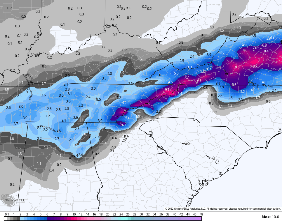
- The best chance for accumulating snow is across the south and southeast.
- Accumulating snows will fall all the way into the deep south as this turns into a major snowstorm through the Mid-Atlantic states.
- Much of the accumulating snows in Kentucky will be on grassy and elevated surfaces as snowfall rates fight a warm and wet ground. Snowfall rates will always win the battle.
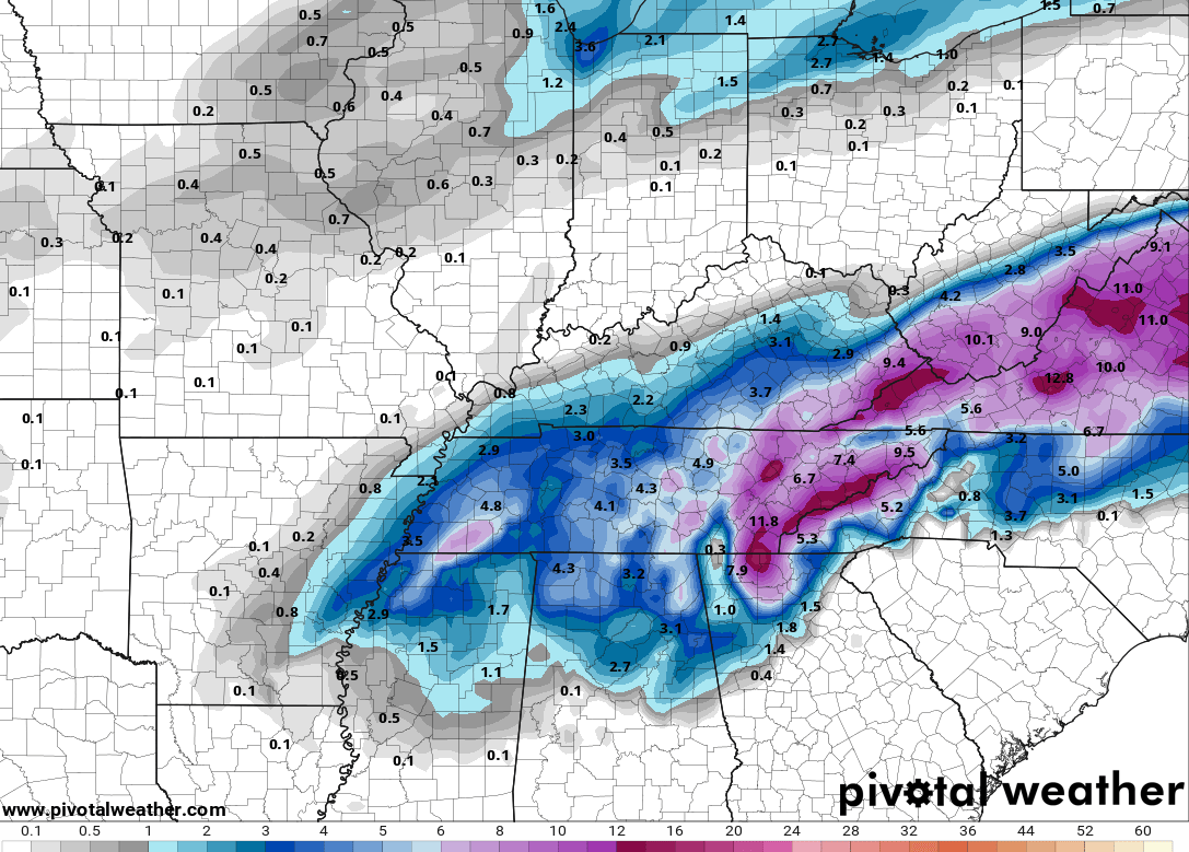
My first First Call For Snowfall of the season is here…

This is a conservative forecast based on the latest guidance, but I have a few more updates to go through later today before we get to the Last Call.
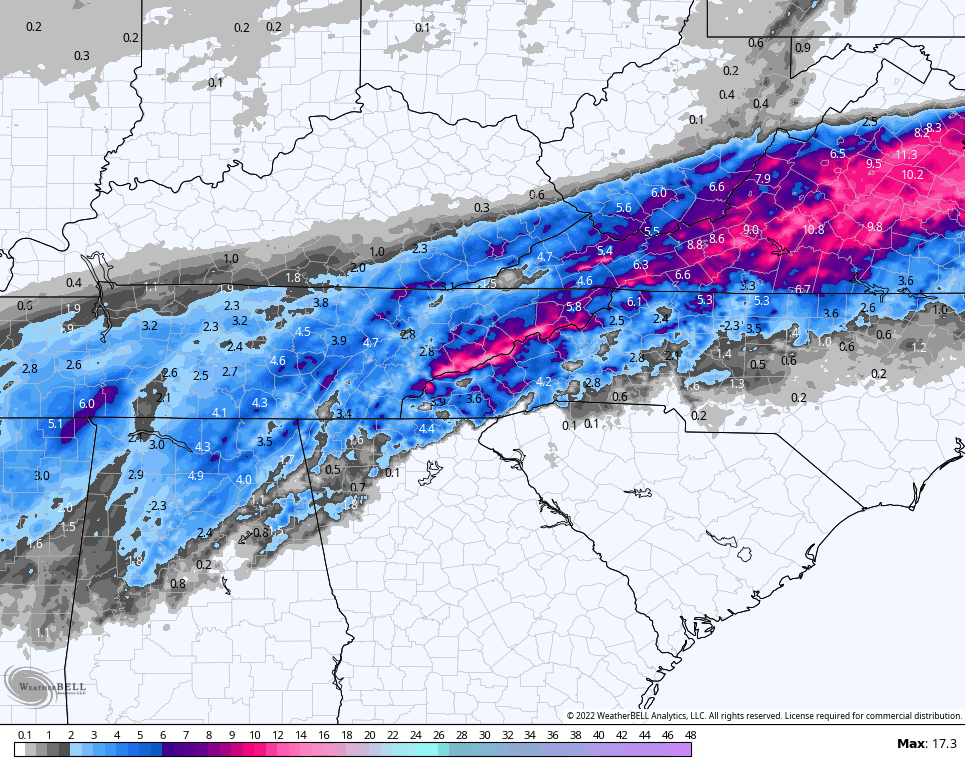
The HRRR was the most aggressive model out of the gate, but now it has friends. Here’s the latest HRRR…

The GFS has joined in on the fun…
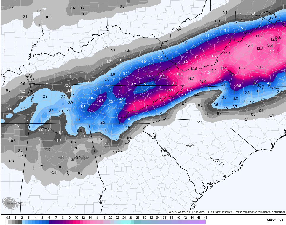
The GFS Ensembles are very enthusiastic…
The RAP has a similar look…
The Short Range Ensembles are in agreement…

The Canadian isn’t as robust, but still has the same areas getting snow…
The EURO is similar to the Canadian…
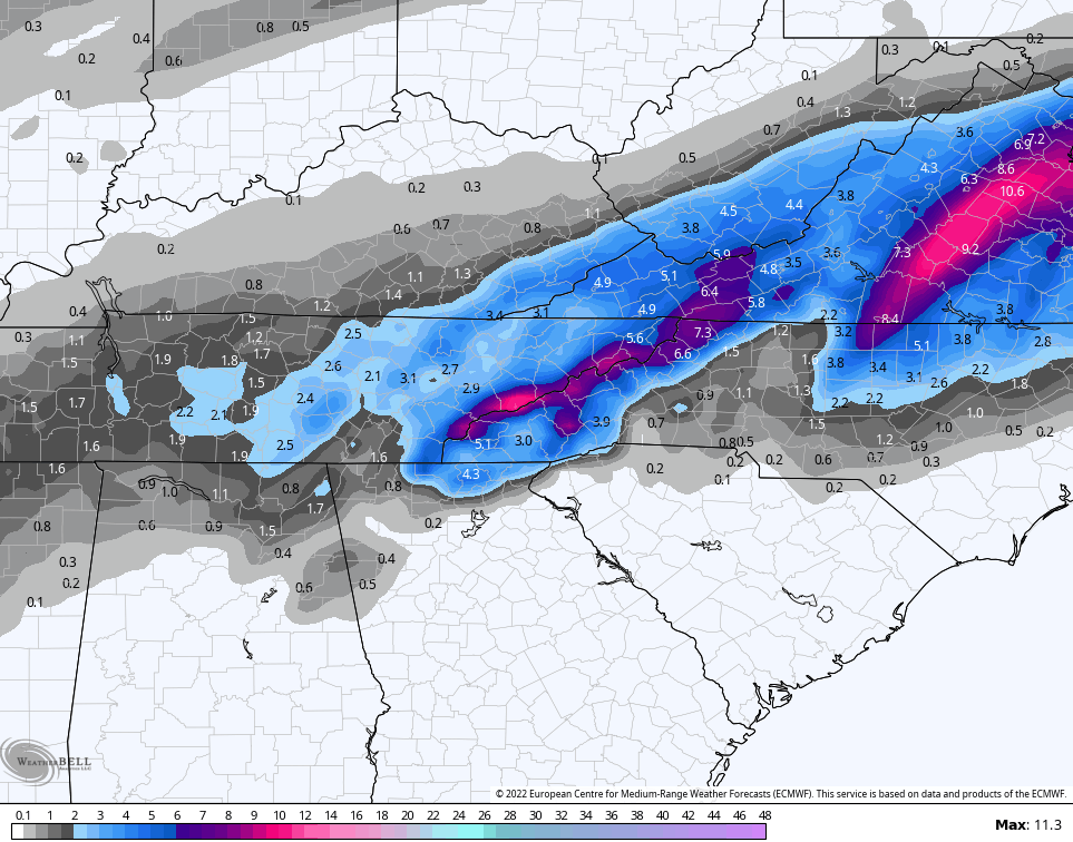
The NAM fam of models were totally whiffing on this system with earlier model runs, but the evening runs discovered it…
NAM

Hi Res NAM
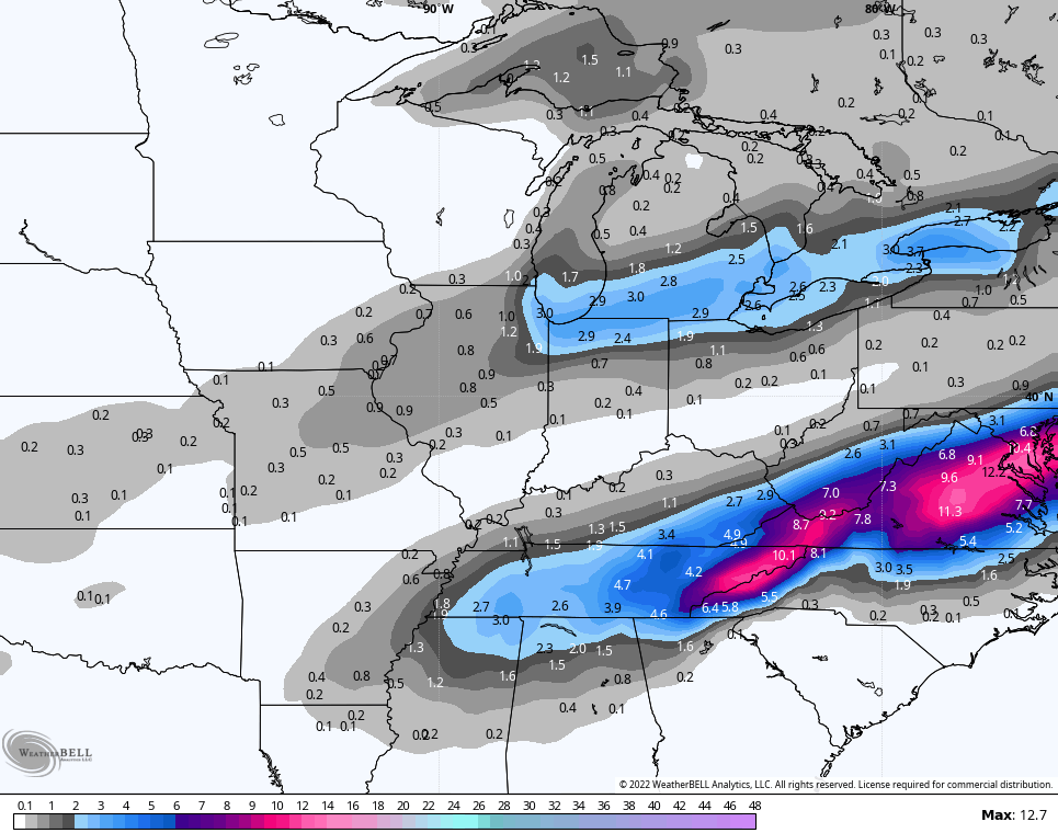
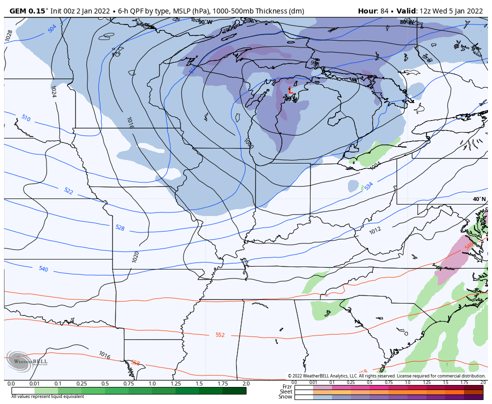
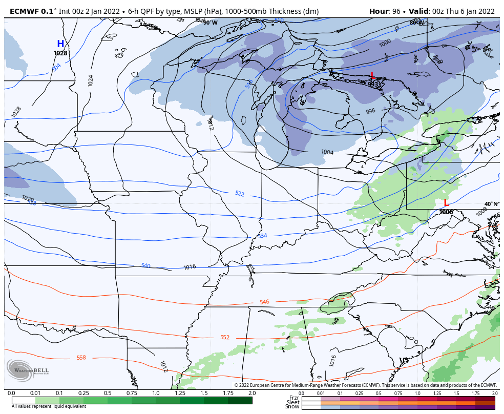
From here, we focus quickly on the next system moving in here by Thursday. An arctic front pushes in Wednesday and has a system diving in right behind it for Thursday into Friday. This is looking more and more like it can become a decent snow maker for much of our region…
Canadian
EURO
I will have multiple updates through the day, so check back. I leave you with your radars to track the early day rains and the blossoming band of snow across west Tennessee and western Kentucky…

Have a great day and take care.

good work bailey boy!!!!!!
He always does good work.
A nice hit for SE Ky.
Thanks Chris, Glad the severe weather is behind us, but yesterday my area of central Kentucky had another close call with a tornado.
Also glad the coldest air of the season is on it’s way for the end of the week, unfortunately it will be short lived as the warmer air will return with Rain according to the NWS next weekend ?
Hope the areas you highlighted for the most Snow receive such. I’m sure a lot of the Snow lovers are getting excited with the forecast of the first accumulating Snow. Especially the Ski Resorts in the Mountains of West Virginia.
My area of Kentucky will have to wait much longer now on that big Snowstorm we keep kicking down the road. If we ever get ENSO back here in Central and in Western Kentucky’s chances may increase for that long awaited Snowstorm. Those are my findings.
Really expected models to back off this morning. I’m biting at 12z.
Nothing to get excited for my neck of woods to recievd snow today, maybe Thursday will be my lucky day. Go Cats!
12z GFS drops the hammer especially in the mountains .
That certainly sneaked up..GFS was hinting at this 3-4 days ago but who would of believed it..If Eastern Ky can get some of the strong deformation bands like models are showing could be tree snapping problems..
Well, yesterday’s snow across the Chicago area was quite the underachiever. 4 to 8 inches was predicted throughout the area, but only 3.2 inches was recorded at O’Hare Airport, and just 2.4 inches at the NWS Forecast Office in Romeoville in the SW suburbs. I live about 5 miles west of the NWS Forecast Office, and only measured around 1.75 inches.
A dry slot moved in from the SW late in the afternoon and early evening, cutting down on the intensity of the snow quite a bit earlier than was expected, and there were no really heavy snow bands that developed.
It seems like everything has to go just right with these winter storms in order for there to be large amounts of snow for an area. If just one thing goes unexpectedly wrong, that really will lessen the snow amount like what happened here Saturday and Saturday night.
Sorry Mike the predicted Snowstorm didn’t pan out for your area. A major Snowstorm is beginning to take shape for parts of Southeast Kentucky Mountains. Good agreement on all models. Not expecting a flake here in Taylor county.