Good midday, everyone. Our significant winter storm is kicking into high gear across the state and is putting down a lot of snow. This is leading to big time travel troubles across the entire region and that will be the case through early Friday.
There isn’t a lot more left to say about today’s winter storm. Here’s a look at the current Winter Storm Warning…

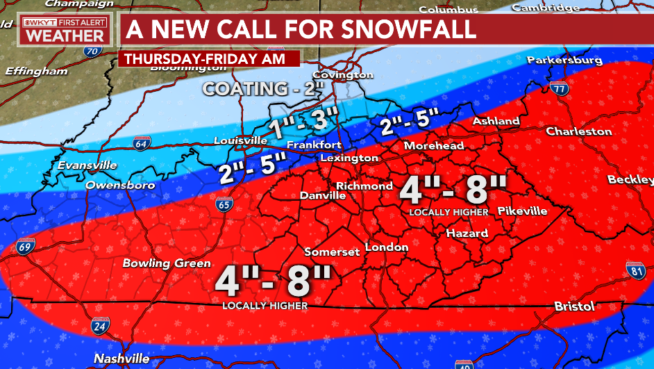
That matches up well with the forecast from last night…
Roads are closing because of the heavy snow and we may very well have a lot of motorists stranded through the rest of the day. Please stay off the roads.
I have you guys all hooked up with your radars and cams to track this winter storm across Kentucky. I will have updates through the day and on WKYT-TV.

LEXINGTON


LOUISVILLE


FRANKFORT

BOWLING GREEN


E-TOWN

GEORGETOWN

MT. VERNON

LONDON


CORBIN

SOMERSET

PIKEVILLE

Mt. Parkway near Slade

MOREHEAD

Make it a good one and take care.

So far it has been a very steady moderate snowfall in Richmond. Are we expecting heavier snowfall? Regardless, looks like the minimum totals expected are a definite lock.
Heavier now… Might be hitting the higher numbers! Hmmmm. Wonder who was saying this would probably not be much of a headache for drivers, about day ago? Probably not a fan of showing models 😉
3 inches in Corbin
This one is looking like an over achiever here in SE Lexington.
Yep, we have about 7″ in North Richmond already. CB did say some areas could have heavier bands.
OK wow – this forecast turned out to be dead on…
LOL, maybe even understated for some- depending on how much more snow time.
Snow has ended here far western, ky we pick up around 3 inches. Now gotta deal with the cold until Saturday. Stay safe and warm
KLEX daily climate update as of 445 pm says 4 inches of snow……Precip amount 0.44 inches……..that would mean it’s less than a 10/1 ratio. Seems wrong.
Pushing 9″ inches in north Richmond now. A great day for a Bubba buster. 😉