Good Sunday to one and all. Heavy rain is rolling across the region early today and it has another shot of cold air chasing it and that’s also leading to some big winds. This may cause a few issues with the high water threat early on and the potential for a quick ice up late today and tonight. This takes place as I continue to look ahead toward a very wintry setup ahead of us.
Let’s kick this Sunday party off by talking about what’s going on out there today. Rounds of heavy rain and some thunder continue to press through here during the morning. The rainfall might be enough to cause, at least, some local high water issues. Here are your radars to follow along…

Winds are the other storm of the day as gusts of 40-50mph may show up along and ahead of the cold front moves through. This front will then usher in a rapid drop in temps from northwest to southeast this afternoon and evening. By Monday morning, temps are deep into the teens…
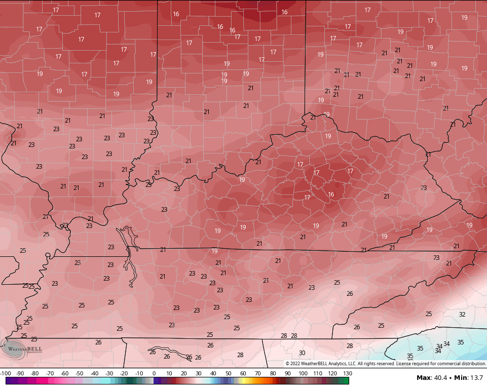
This rapid drop in temps means we are on guard for a flash freeze. All this water from the heavy rain and snow melt will freeze up and we may very well be talking about slick travel conditions.
This blast of cold hangs into the middle of the week and that sets the stage for a system working at us by next weekend. The models are trying to figure out how to play this.
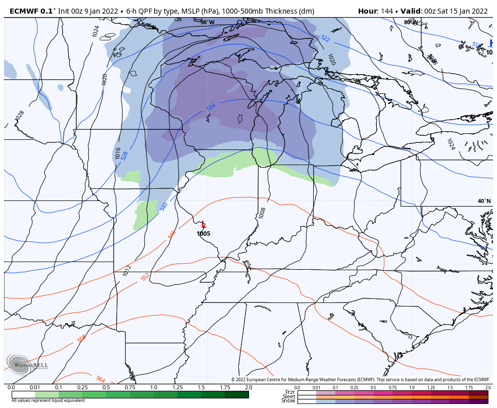
The EURO has a bowling ball type of a system that can turn fun…
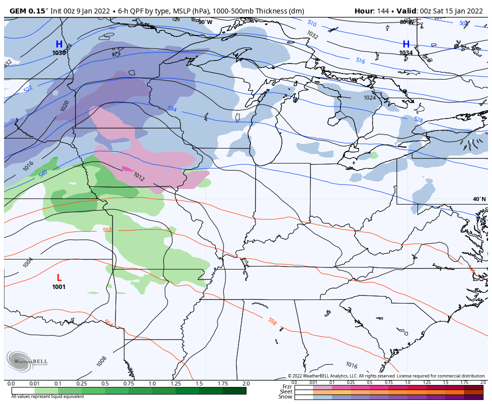
The Canadian has a similar thought process, but isn’t nearly as strong…
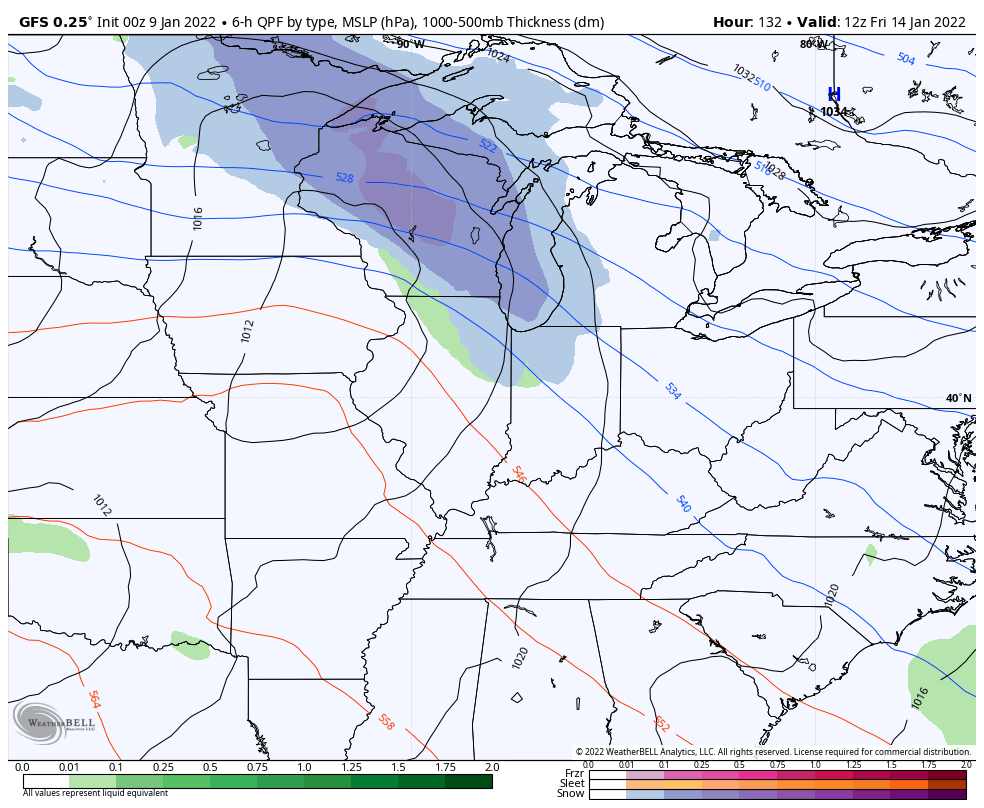
The GFS is way too progressive as usual…
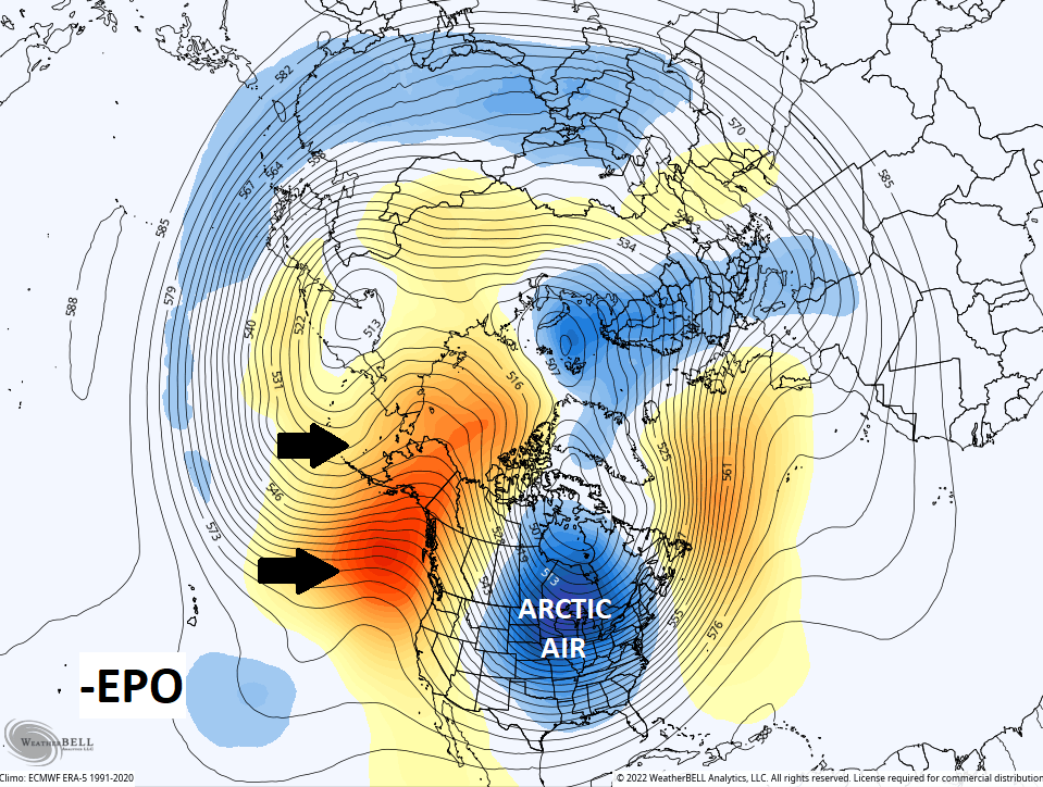
The overall change in the pattern across North America has been amazing to watch over the past week and it’s not done yet. The pattern taking shape for the middle and end of January is one likely to feature harsh winter weather for many across the country. The setup before forecast across the northern hemisphere is one that has a chance to bring the North Pole into the country. One of the biggest drivers of this is a negative East Pacific Oscillation. This effectively sets up a stable trough east of Hawaii that jacks up a ridge over top of it. That ridge extends through Alaska toward the other side of the Pole. This dumps a deep trough into the central and eastern parts of the United Strates allowing for a direct discharge of arctic air…
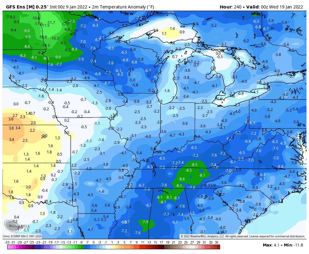
The ENSEMBLES are giving us some absolutely crazy cold temperature departures in the extended…
GFS ENSEMBLES
CANADIAN ENSEMBLES
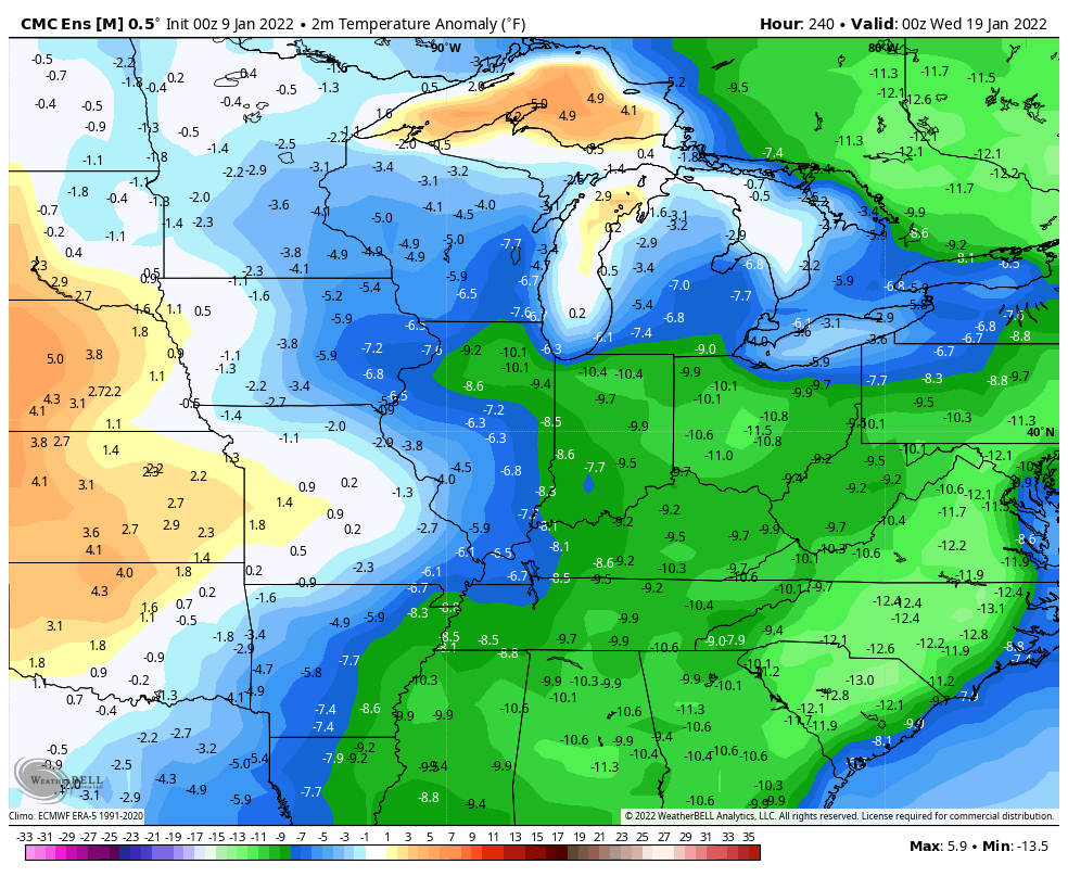
Ensembles are averages of many different runs and those get smoothed out over time. Seeing numbers like that should raise some eyebrows.
It seems like I’ve seen this winter pattern somewhere before. Hmmm. Oh. The winter of 1984/85. Have I mentioned that one before? 🙃😜
I will have updates later today. Make it a good one and take care.

So what was the seasonal snow total the winter of 84/85 here in Lexington? Does anyone know?
I would have been living in western NC. I remember it being super cold in January and the water falls froze…there was snow, but I don’t remember how much. Wasn’t that the winter Knoxville TN got to -25 F I think?
Mark, I found this snowfall information for Lexington 🙂
https://www.currentresults.com/Yearly-Weather/USA/KY/Lexington/extreme-annual-lexington-snowfall.php
In 1984-85, I was living in Vanderburgh County, Indiana and the lowest temperature was -17 in mid January 1985, and we had a snow cover, but I don’t remember the amount of snow that accumulated that Winter.
It’s 49° right now in the Bowling Green area, and we’ve picked up 1.70″ of rain overnight. It continues to pour, with radar indicating even heavier precip over the next couple of hours. Water is standing wherever I look, which is not surprising, since the ground is frozen solid just a few inches below the surface, and I would not be surprised to see a flash flood warning declared in Warren County later this morning. Much of that water will freeze solid this evening, making a bad situation situation even worse, and based on the news about the EPO, an intrusion of the Polar Vortex is a very real possibility, especially if we get a period of stratospheric warming.
I’m afraid that this Winter is just getting started.
I agree Joe, the Winter weather season is just getting started. Warmer waters moving back in the Gulf of Alaska would definitely indicate a signal that ENSO may be making an appearance sometime later next month ?