Good Friday, folks. Today is going to be an interesting day with two rounds of snow impacting the state. The second round is getting more of my attention as it may contain some absolutely blinding snow squalls this afternoon and evening.
Our first system is impacting areas of northern Kentucky, especially from the Lexington metro and northeast. Some amounts of 1″ or a little more may show up within this corridor to cause slick travel for the morning drive…

That does not mean everyone in that area sees an inch of snow, but I’m highlighting the region most at risk. Some delays and cancellations will show up in this area. That snow band will then sink toward the southeast with light accumulations through the day.
The next system is a potent disturbance dropping in from northwest to southeast. This will cause widespread snow showers to increase for much of the area, but some intense bands of snow squalls will also likely show up. Here’s the area most at risk for seeing these intense bands of snow…
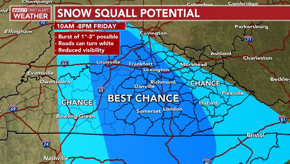
These snow squalls are likely to cause some big travel issues for a time, so please keep that in mind if you’re travelling in the highlighted region.
Again, the above map is strictly for the snow squall potential. Snow showers will be fairly common in most of central and eastern Kentucky through early Friday evening.
Behind all this comes arctic air and the potential for single digit lows again by Saturday morning. Wind chills will go below zero at times across central and eastern Kentucky.
The setup for next week is looking a little more interesting as the models are beginning to trend colder quicker. The EURO has the next system moving in on Wednesday with now more of a fence setting up with rain/mix and snow…

That sets the stage for a bigger system rolling through right behind that into Thursday…

There’s a lot of harsh winter weather ahead of us, folks.
I will have updates later today. I leave you with your snow tracking tools for the day…

LEXINGTON


LOUISVILLE


COVINGTON AREA


LONDON

CORBIN

SOMERSET

MT. VERNON

PIKEVILLE

Mt. Parkway near Slade

MOREHEAD

JENKINS

PINE MOUNTAIN

FRANKFORT


GEORGETOWN

MAYSVILLE

Make it a great day and take care.

Thanks Chris, we had a light dusting of Snow early this morning which amounted to 0.4 inches.
Snow Showers are in our local forecast, but no mention of Snow Squalls. Years ago in South Central Indiana on Easter Sunday we had a very heavy Snow Squall which accumulated to 4 inches.
The GFS is predicting 0.41 inches of ICE late next week for Maple. UGH !!!
We will be hearing more about the Big Time Nor’Easter and I believe there will be more to follow through February.
Next week looks interesting, oh wait western,ky is under a dome it will somehow miss us.
That is weird that your area has not had a flake of Snow this Winter. I’m not that much farther from Western Kentucky and my area has recorded Snowfall at 11 inches in January.
Every run on the GFS has us getting an ICE STORM next Friday. I hope this changes ?
Seems like Kentucky is an ICE MAGNET because when it is predicted well in advance it happens and when Snowstorms are predicted they don’t materialize. Go figure ?
We did received about 2 inches earlier this month and on the average were 10 inches below normal. Maybe February will get us to catch up. But after February I’m ready for team spring , the thing is we had some dandy’s snowstorms in March in the past and for some reason the way this pattern is lock in i have feeling we maybe digging snow in March.
Yeah, when I was living and working my Nursery in Vanderburgh County, Indiana we would often receive those heavy wet Snows and sometime Thunder Snow in late February and March.
Some Meteorologist are calling for a significant shift in the weather pattern after next weekend to a “false Spring” here in the Ohio Valley and east. Expecting the Southeast Ridge to push the trough to the West. If this happens it would bring plants out of dormancy much too early only to be frozen or killed with another late freeze in April. This is happening more often now. If the plants do freeze it will be the seventh year this awful process has occurred.