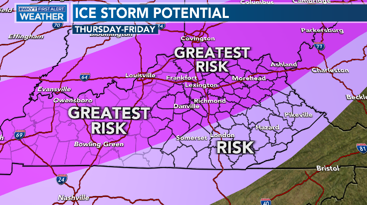
Good Tuesday, everyone. My concern is growing for a significant amount of freezing rain and sleet to cause big time issues across much of Kentucky Thursday and Thursday night. Moral of the story, a true ice storm is possible for many areas.
In addition to the potential for significant icing, we are also facing the potential for heavy rain. This heavy rain may cause some, at least, local flooding issues to develop.
Let’s get you a new breakdown:
FREEZING RAIN/SLEET
- Temps crash from west to east late Wednesday night and Thursday.
- As this happens, freezing rain and sleet show up just behind a slow-moving front.
- Areas of western and northern Kentucky get in on the icy action first and that comes as early as late Wednesday night. That slowly sinks toward the south and east Thursday.
- Sleet may really add up for some parts of the region. Sleet is better than freezing rain as it doesn’t stick to power lines.
- The greatest threat for significant amounts of freezing rain will be across western, northern and central Kentucky. This whole potential is slowly sinking farther south.
- The ice storm potential is now my number one threat.
FLOODING
- Heavy rain is likely to fall across much of the state Wednesday through Thursday.
- A general 1″-3″ will be possible with locally higher amounts.
- Flash flooding and general flooding will both be possible.
SNOW
- Much of the snow associated with this system is likely to our west and northwest.
- That said, there is more of a trend to try and get some better snows south of the Ohio River into the state.
- Any deviation in where the front slows down could result in better snow chances around here.
TEMPS
- Readings can spike into the 50s ahead of the front.
- A 20-30 degree temp drop in an hour or two is likely when the front moves through.
- The temp map late Wednesday and early Thursday may feature a more than 30 degree difference from west-east across the state.
- Lows by the weekend can reach the single digits once again. Can we go below zero? I can’t say no.
As far as the potential for a true ice storm of .25″ of more of freezing rain, here’s a look at my current thinking…
The latest GFS continues to trend colder faster and that pushes everything a little farther south and east compared to earlier runs…
That snow signal getting into northern Kentucky has actually been showing up a little more with each run of the model over the past day or two.
The Canadian continues to have a scary look…
Notice how the Canadian is sinking that snow line farther south compared to earlier runs.
The EURO is also going farther south compared to previous runs…
The NAM has very little snow, but has a lot of freezing rain and sleet…
Bitterly cold air comes in behind this and the numbers by Saturday morning could absolutely tank. Single digit lows are likely with the chance to go below zero if skies completely clear.
The GFS says look out below…
Ummm, no thanks!
The next system follows this up with a mix and snow Sunday into Monday as the hits keep on coming.
I will have updates later today and on WKYT-TV starting at 4pm. Until then, have a good one and take care.


I hope it keeps creeping south..
I rather have sleet than Fz. rain.
The GFS is now predicting 0.85″ of ice for WarrenCounty, but I believe that the NAM’s negligible amount is more on target. I’m also convinced that the combination of heavy rain on frozen ground, with its resulting runoff and flash flood potential, is a greater threat, which is why I can’t understand why the NWS hasn’t posted an aereal flood watch for the county.
Hope that snow line keeps going further south.
Thanks Chris, and I appreciate that you are showing all the main weather models so we may compare. Doesn’t seem like there is a lot of agreement, meaning this weather event may change ? For the better I hope.
Looks like heavier amounts are not as widespread on the Nam..Central parts going NE towards Morehead looks like what most models are keyed on for the heaviest ice..Still time for some SE shifts so SE Ky may get some heavier amounts if trends continue..
Excuse me, Mother Nature and Father Winter….when I placed my order I specifically asked for NO PINK!
This will be a historic snowstorm for Central IL and Northern IN as extreme amounts are forecast, in excess of 18″. Here in the Chicago Metro Area, 5 to 11 inches are predicted by Wednesday evening where I am in the SW suburbs, with lesser amounts further to the north and northwest. There is going to be a very sharp cutoff from the heaviest snow in the NW suburbs,
Winter Storm Warnings are in effect for much of IL as far north as Chicago and Cook County.
Mike you may receive more Snow than you want. A lot of moisture is involved in this overrunning event. My Sister lives in Northern Indiana where they are expecting over 20 inches.
If I have electrical power after this awful Ice event has past, I will let everyone know the extent of the property damage that may occur.
Not looking forward to this freezing rain potential. I actually needed milk today and went to the store. LOL Got the last 2 gallons ! Just for kicks I cruised the camping and candle aisles. No lanterns, no fuel, no candles, no batteries either. Hoping we don’t have a repeat of 2009.