Good afternoon, folks. We continue to watch the increasing potential for severe storms and high winds to impact the region on Thursday. This comes as a powerful storm system rolls into the Ohio Valley from the southwest and gives us a serious clash of the seasons.
As expected, the Storm Prediction Center has upgraded much of the region to a Slight Risk for severe storms on Thursday…

That’s almost spot on to the map I first put out last Friday…

Damaging winds are the primary player as a line of strong to severe storms races from west to east across the state Thursday afternoon and evening. The GFS continues to spit out some serious wind gusts…

The Hi Res NAM is on board with this…

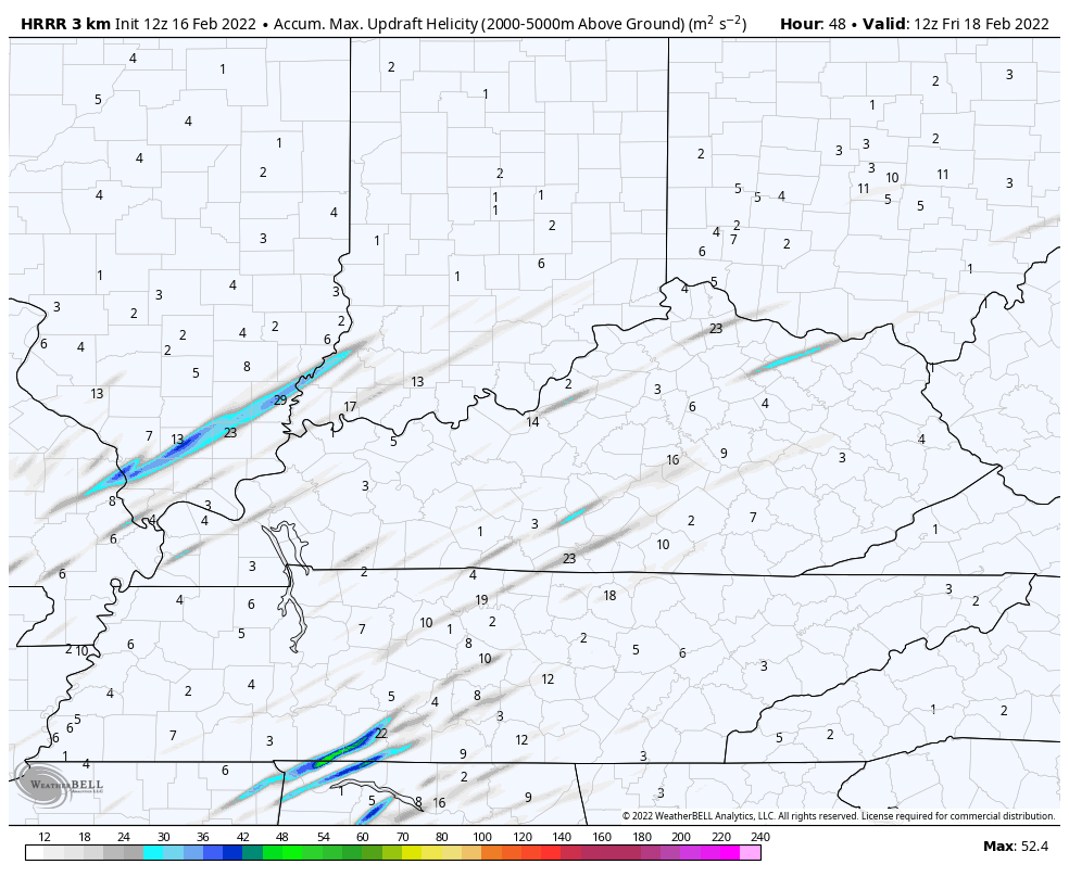
There is also a small tornado risk and we can see this showing up on the HRRR. The streaks from southwest to northeast show the model seeing the potential for rotating storms…
These storms may also put down a quick 1″-2″ of rain, leading to the potential for local high water issues.
Temps ahead of our front may spike into the 65-70 degree range then fall into the 20s behind the front by Friday morning. That’s when some snow showers and flurries should also be flying.
The pattern turns milder late weekend into early next week ahead of another setup where we get a clash of the seasons to set up on top of us. This may lead to waves of low pressure bringing heavy rain and storms in here, but the cold air will have much more of a push behind this. That could also spell some winter weather as the pattern trends much colder to end the month and roll into early March.
This pattern is loaded with potential for a lot of precipitation… Both rain and snow… As we head into March.
I will have the latest on the severe threat starting at 4pm on WKYT-TV. Take our interactive radar out for a trip to the plains and Mississippi Valley to track the storms as they work toward us…
…

Enjoy the rest of the day and take care.

Batten down the hatches.
Horrible Climate !
It’s the warmest day of the year here in the Chicago Metro Area today, with temperatures around 50-51 degrees, which has melted virtually all of the snow.
Winter Storm Warnings have been issued for much of the region here for Thursday with 3 to 7 inches of snow predicted, which will re-establish the snowpack. Strong winds will be a major player too.
Mike, I looked up NWS in Chicago and they are concerned about flooding issues as the creeks and rivers have the potential for Ice backing up the water ?
The GFS had your area receiving from 12 to 18 inches of Snow after a short period of Freezing Rain and Sleet. I would rather have that weather type than this awful wind we are having today.
Instead of having a Snowstorm to look forward to, we have the possibility of higher winds tomorrow along with a chance of Tornadoes.
Horrible Climate !
Right, the NWS is concerned about the melting ice on area rivers, along with the predicted rainfall of a half-inch to an inch tonight.
It looks like the heaviest snow totals Thursday will be south of the Chicago area and the I-80 corridor, but the Chicago area will still receive a decent amount, anywhere between 3 to 8 inches with the heavier totals South and SW of the city.
The NWS is also concerned about the strong winds which will greatly lower visibility in the falling snow.
The SPC puts the northern extent of the Enhanced Risk on the KY/TN border, saying that despite instability aloft, a cooler boundary layer will exist at the surface, which will suppress supercell development. However, with a 120 knot jetstream positioned over Western Kentucky, if we get some morning sunshine, that boundary will destabilize, increasing the likelihood of meso development.
The similarities between tomorrow’s setup and what we had in mid-December and New Years Day are worrisome. Hopefully that boundary layer hangs tough, and that these types of conditions do not persist when our “real” severe weather season kicks off in April/May. I’m not optimistic…
I’m hardly ever optimistic when we have this potential for damage to home, property and life.
Hoping this system fizzles out and we get back to a more normal temperature pattern.