Good Thursday, folks. We have a very active weather day taking shape across the state as severe storms and high winds roll through here. This is just ahead of a dramatic temp drop blowing in behind a potent storm system.
Let’s give you a little breakdown of how this system plays out:
- Scattered showers and storms will be common across the state today and some could have very gusty winds.
- A line of strong to severe storms develops early this afternoon across western Kentucky and rolls eastward this afternoon and evening.
- Damaging winds will be likely with this line.
- A few tornadoes are also possible.
- The prime time for this line is early afternoon in the far west. Between 3pm and 6pm for the Interstate 65 corridor. Between 4pm and 7pm for the Interstate 75 corridor and then between 7pm and 10pm for eastern Kentucky.
- With or without thunderstorms, winds may gust to 50mph or a little higher.
- Heavy rainfall of 1″-2″ in a short amount of time may cause some local issues.
The Storm Prediction Center continues to show the increasing severe weather potential around here…

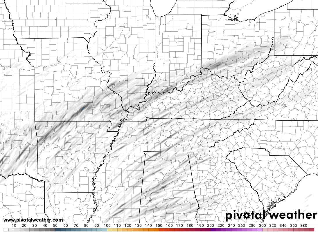
I mentioned the potential for a few tornadoes and the short range models are showing this potential. You can see the streaks of rotating storms showing up on the WRF…
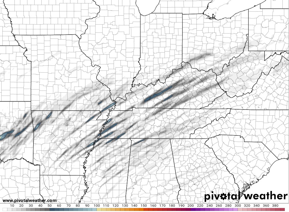
And the HRRR…
Temps crash behind this front with flurries and snow showers coming in here late this evening into early Friday. Temps today are in the 60s then drop into the 20s from northwest to southeast overnight. Wow. Wind chills will make it feel much colder.
As we look farther down the road, the cold start to the weekend turns much milder by Sunday with temps rebounding even more early next week. That’s ahead of what looks to become a super active setup next week. It’s on that can bring a lot of rain to our region before winter tries to flex some as we get into the closing days of the month.
I will have additional updates later today and I will also have the continuing coverage as needed on WKYT-TV.
As usual, I have you all set to track the severe weather. Our exclusive interactive radar also features live storm chaser video streams, so be sure to check that out…

Current watches

Possible Watch Areas

Enjoy the day and take care

Thanks Chris, At the Present, the Radar shows the Heaviest Rains are North of the Ohio River, and look to be Heading Northeast through Southern Indiana towards Ohio. I’m hoping the Heavy Rains move more South into Central Kentucky to help Stabilize the Atmosphere. We definitely want Sunshine to be a No Show through the entire Event Today.
Another ” Super Active Setup ” for next Week. Lets Hope Not. I would Like to See A Return to A more Winter Pattern to the End of April, but that’s Not Likely to Happen.
Yesterday, was the Anniversary of the Last Substantial Widespread Snowstorm in the State of Kentucky. The Year was 2015. Too Long Folks.
Adding to the Above, the Winter 2014-15 Featured ENSO in the Weak Phase. At this time, whether We will Ever Return to A Weak El Nino or Remain in the Current La Nina or Neutral Phase is Not Predictable. Another Wait And See Game for Next Fall and Winter.
https://www.lex18.com/anniversary-of-february-15-16-2015-snow#:~:text=This%20was%20a%20winter%20storm,4th%20snowiest%20day%20all%2Dtime.&text=Between%20March%204%20and%205,over%2017%20inches%20of%20snow.
I think the only good news about today’s system is that it diminishes the wild fire threat.
Very little Rain here in Maple. I Just Hope the Sun doesn’t Make it’s appearance this Afternoon and places us in the Severe Sector ?
We’ve been in that dry slot for about a half hour in BG, but radar shows some t-storms just to our south. Dewpoint is 59°; it’s risen 11° since midnight. Had a 41mph wind gust earlier
Rain has Pick up here in Maple and this has lessen the Wind potential for now. Tornado Watch issued to our South and at the same time A Lot of Snow is falling in South Central Illinois. I hope this mess is out of here by later this evening ?
All Winter Storm Warnings for the Chicago area today have been cancelled and downgraded to Winter Weather Advisories, as the heavy snow band will actually be much further to the south than previously thought, in East Central and Central Illinois. The Chicago area may still get an inch or two.
The area received nearly an inch of rain last night, which obliterated the snowpack. All that’s left are the piles of snow from plowing and shoveling.
I am hoping all the rain we get today obliterates the piles of snow left over from plowing and shoveling. Even yesterday some of the sidewalks had snow and ice on them. Good Riddance.
Mike, I’m Surprised that your Area miss the Snowstorm. Earlier it look like a Sure Bet for a major Snowstorm. I’ll never trust these Weather Models anymore.
WE had pretty steady rain here or at times heavy rain here in Western ky. all morning long and still coming down Just looked at the radar the heavyban ds of rain or thunderstorms are approaching stay safe everyone
The trough (can’t really call it a warm front…) has pushed north of Bowling Green, and the current temperature is 61°. The rain has stopped for now, the clouds are thinning and based on the current radar, we could be seeing a break in precip for the next hour or so. The Sun has popped out in Mississippi, further destabilizing the atmosphere down there…I sure hope that it doesn’t here!
Storm Chasers reported a possible Tornado entering Yazoo City, Mississippi earlier this afternoon prompting a Tornado Warning for that area.
Dry Slot beginning to move North towards Central Kentucky. I wouldn’t be surprised if a Severe Thunderstorm Watch or Warning will be issued later for our area of Kentucky.
Rain has been Off and On here in Maple, and I won’t Know how much Rain has Fallen until this Storm is Over and Out of Our Area.
I don’t Believe the Predicted Amount will be Achieved ?