Good Wednesday, folks. We have another decent weather day in progress, but steamy temps and stormy skies are on the way. This is a pattern that takes hold of our 4th of July weekend and then continues into the first full week of July.
Before we get into a holiday weekend breakdown, let’s see how the forecast models show rounds of storms firing up. These animations go from Friday through next Wednesday…
EURO

GFS

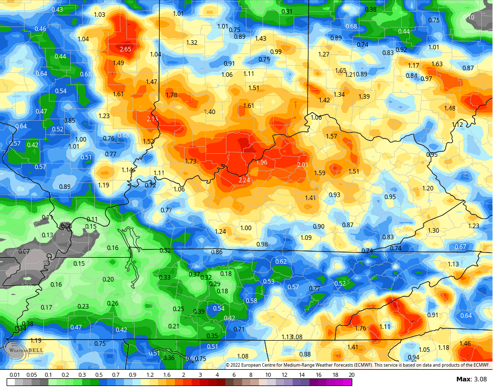
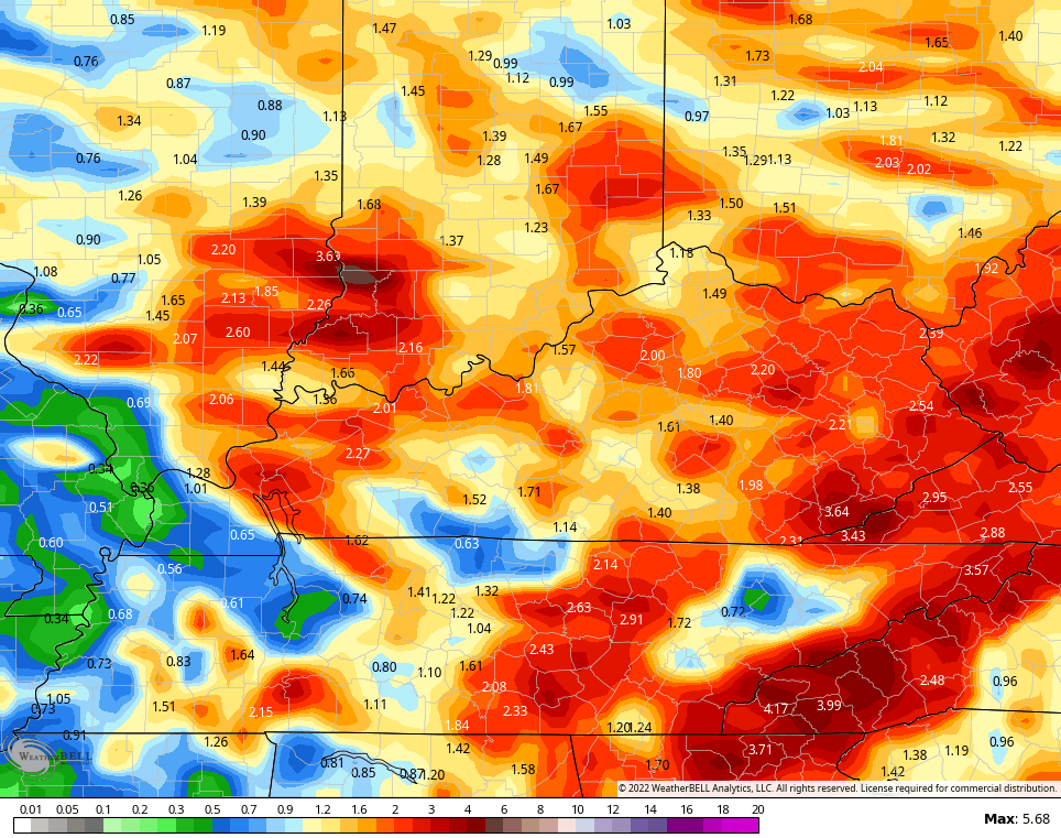
Here are the forecast rain totals through the same time period…
EURO
GFS
Here’s a breakdown:
FRIDAY
- Humidity levels and temps rise in a big way.
- Highs range from the upper 80s to middle 90s across the state with a heat index much toastier.
- Scattered showers and storms go up during the daytime.
- The best chance for a few strong storms will be during the evening.
SATURDAY
- Showers and storms look to increase.
- Storms may be strong and put down heavy rainfall for some areas.
- Some local flash flood issues will be possible.
- This doesn’t look like all day stuff.
- Temps come down into the 80s, but it’s muggy.
SUNDAY
- Scattered showers and storms will be around once again.
- Lots of dry breaks will also be noted.
- Temps spike back into the upper 80s and low 90s.
4TH OF JULY
- Steam and scattered storms will be on hand.
- We will have to watch for clusters of storms to dive in from the northwest.
- This doesn’t look like washout material at this point.
- It’s very humid with temps ranging from the upper 80s to low 90s.
As we look longer range for the month of July, the EURO weeklies are actually indicating above normal rainfall…
ENSMBLES
CONTROL RUN
Of course, we are getting into the time of year where the tropics can play a big role in our overall weather pattern. The NHC is monitoring several systems…

One system is expected to develop into a named storm, but this is taking an incredibly far south track…

That’s crazy to see this early in the season.
We also need to watch that system nearing Texas and Louisiana…

That may increase before coming ashore. Can some of that moisture get entrained into the the front slowing down around here this weekend.
Make it a great day and take care.

Considering all the heat we’ve put up with over the past couple of weeks. it’s interesting to note that this week we observe the 10 year anniversary of record breaking temperatures that hit the Bowling Green area in 2012.
June 28, 2012 – 106°F
June 29, 2012 – 110°F
June 30, 2012 – 108°F
July 1, 2012 – 105°F
2012 was a year marked by a significant drought, and 10 years later we’re in the midst of 22 straight days w j
…without measurable rain!
Yep – well hopefully…this looks like a chance to get some instability and storms from the heat…a few days in a row…fingers crossed! For some reason, I remember 1999 being terribly dry If it wasn’t 1999…it was either the year before or after…but I never hear anyone mention that. I feel like that summer it didn’t rain at all. At that point, I hadn’t lived in Lexington but only about 3 years..
The highest Summertime temperature I’ve ever experience was 106 degrees in the Summer of 1976 in Southwest Indiana. This was recorded at Dress Regional Airport on the 4th of July.
That was the same year we hit 105 in Winchester in persistent drought conditions. I played golf that day and hit a ball 300 yds thanks to a fairway that played like an airport tarmac. Lol
We all could use some rain.
I am glad to see that the rain will not be an all day event.
Thanks Chris, fifty two degrees here in Maple this early morning and still under dry skies. Hoping and praying we receive some much needed rains soon, but not on the Fourth of July !
The system in the Gulf of Mexico looks interesting. If the system develops, it will likely ride the Northern Periphery of the Bermuda High Pressure that is centered just to our South.
In the next few days, we will have to wait and see if the Bermuda high Pressure’s Northern edge is in our area of Kentucky. If not, we may not receive that much needed rain and the Drought continues to get worse, but local Droughts don’t last forever Folks, but it may seem like they do if your in the Agricultural Industry.
If I recall, it was 1999 when the Herald-Leader published articles regarding Lexington talking about pumping water from the Ohio River to replenish the water supply because the drought was so bad. I know that year I tried to play golf and there was no grass, just dirt. 2007 was another bad year from a hydrological perspective.
Due to gas prices I have not had a chance to get down to Lexington and points south recently to see how bad things are getting this year. Up in the far Northern parts of Kentucky things still look fairly green. Hopefully these situations change soon.
Also today is the 10 year anniversary of the destructive Derecho that tore through the Midwest, including far Northern Kentucky.
https://storymaps.arcgis.com/stories/d009e98baa2d46b48093e82d27b1d18a
This was especially bad in Ohio where I was working at the time. Our office building lost power for 24 hours.
Interesting article on the Derecho. Hope that doesn’t happen again ? That’s one thing we do not need in this crazy time we currently have.