Good Monday and Happy 4th of July! On this Independence Day, we are getting ready for a massive heat wave set to engulf the bluegrass state this week. To shake things up a little more, strong to severe storm clusters will drop in from the northwest from time to time.
Let’s begin with our 4th and roll forward. The heat begins to build into the region from west to east. Many thermometers today reach 90-95 with temps a touch cooler in the east. There’s the chance for a few scattered showers and thunderstorms to go up and this may interrupt a few parades and fireworks shows. As of now, this does not look widespread.
Here are your radars to follow along…

Our heat wave kicks into high gear on Tuesday as temps make a run toward 100 degrees. This is when we also have to watch that northwestern sky for clusters of strong to severe storms dropping in here. The Storm Prediction Center has much of the region in the severe threat for Tuesday…

This matches up with the map I put together over the weekend for the rest of this week…
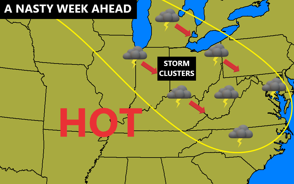
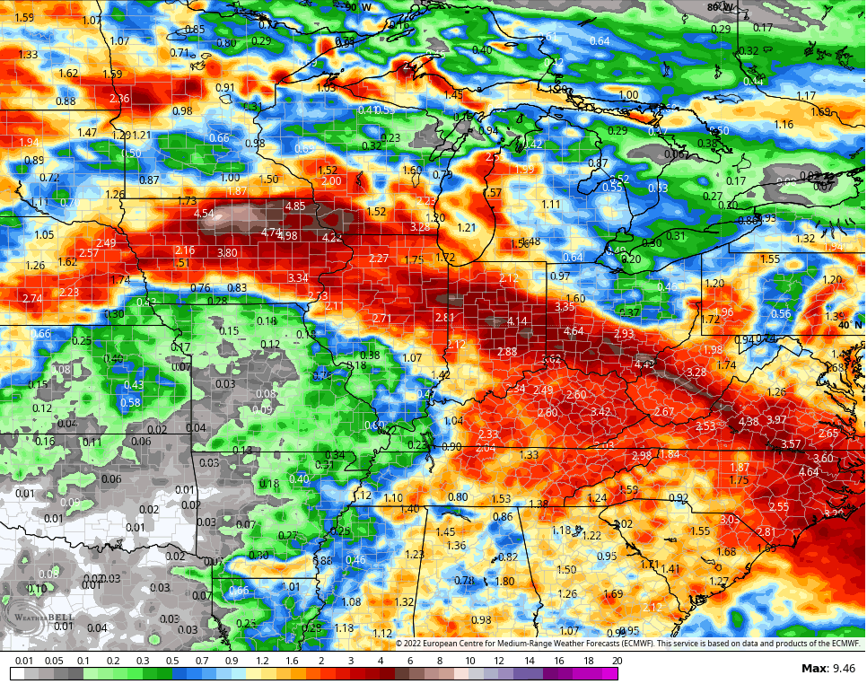
Damaging wind is the main threat from these storm clusters that will be around through the end of the week. Thes storms may also put down a lot of rain and the EURO matches up well with my map…
Here’s the animation of the storms…

You can see that on the GFS…

In terms of temperatures, high temps can make a run at 100 degrees on more than one occasion through the end of the week. Of course, showers and storms will have their say as any day featuring storm complexes will come in much cooler. Here’s the high temp take from the GFS…
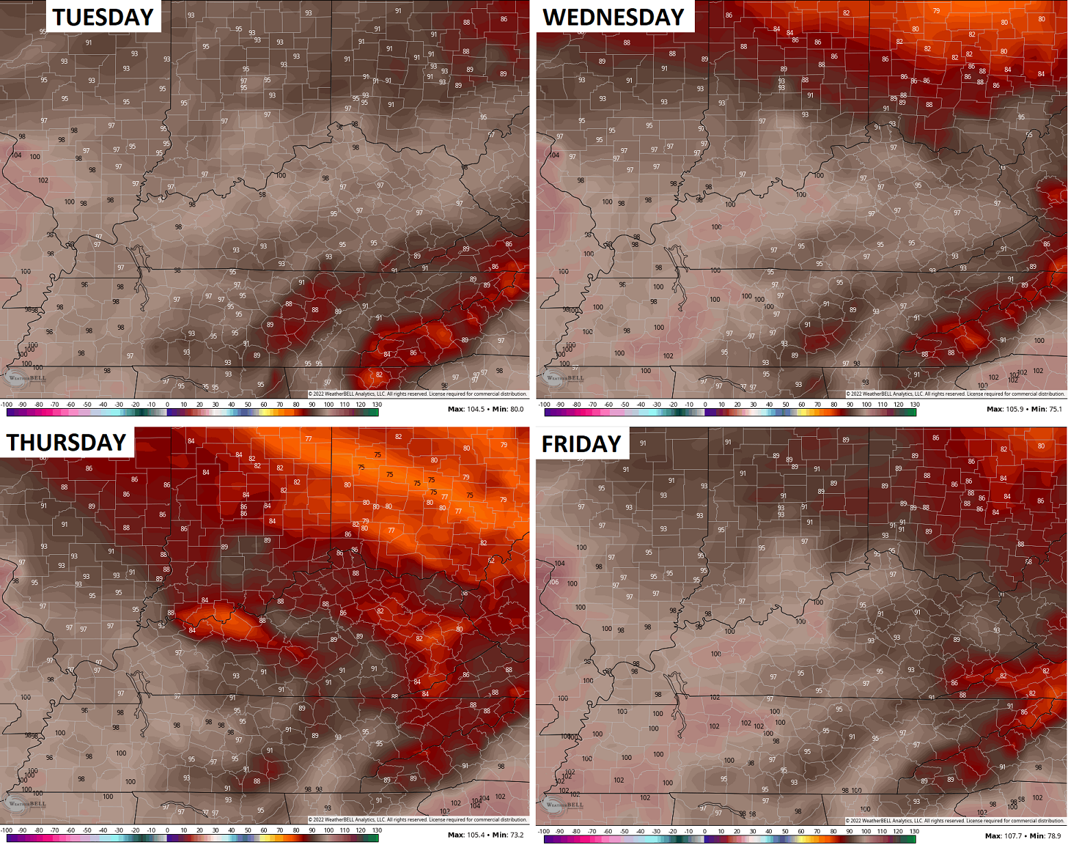
Heat Index numbers can approach 110 at times, especially in the west.
Have a happy and safe 4th of July! Take care.

On Saturday, the string of 26 days without rain was broken, at least it was in the immediate vicinity of my PWS just south of Bowling Green. I recorded 1.01″ of rain, which fell during 2 storms that hit between the hours of 9:00am and 5:30pm, but this precipitation was extremely limited in area. A local observer who’s station is located about 3 miles north of mine received less than 1/10″ and another individual about 2 miles to the East/Northeast received less than 0.20″. This is why the burn ban remains in effect for all of Warren County, and with temperatures expected to exceed the 100° mark on several days this week, that ban will not be lifted any time soon. The backdoor cold front should have a decent chance of provide Cincinnati and the Lexington area some relief, but I’m afraid that the capped atmosphere over Warren County and points West will remain high and very dry. We can expect to see Excessive Heat Warnings issued for the South and West on one or two of f redd
…on one or two days this week.
We only received 0.48 inches of rain since July first and with a very pronounced increase in humidity and dew points. No relief from the heat in my local forecast is expected over the next seven days except for maybe a thirty percent chance of scattered rain showers in the late afternoon each day.
Burn Bans are most always in effect in my part of Taylor County unless of course we receive some substantial rains over a long period of time.
The Strong Bermuda High Pressure Ridge, centered to our South will begin to weaken sometime and maybe we will return to our Normal Summer Weather Pattern ? We can only hope and pray it will be sooner than later.
Everyone, Please Try and Have a Safe and Enjoyable Fourth of July, 2022.
HAPPY BIRTHDAY AMERICA and MAY GOD BLESS !!!
r, which is usually strong will begin to
My typing messed up please omit : r, which is usually strong will begin to