Good Sunday, folks. It’s another hot and VERY humid day across the Commonwealth, but that’s about to change. We are going into a stormy setup that’s likely to put down a lot of rain in the coming week and this may lock in for August.
Temps today are back into the low and middle 90s for most of the state with humidity levels stealing the show. That makes the heat index hit 100 or better for many areas.
A front drops in from the northwest tonight and Monday and will bring showers and storms back into the picture. A few of these storms may be strong or severe and the Storm Prediction Center has the north in the low-end severe threat later this evening…

That threat focuses a little farther south as we head into Monday…

The boundary moving in here slows down and is likely to hang around for most of next week and may even stick through next weekend. That means rounds of showers and storms will be likely. Check out the EURO animation from late tonight through Friday…
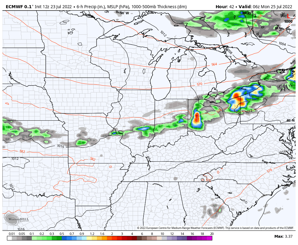
You can see how it presses the boundary just to our south at the end of the run, but it brings it right back north over the weekend. The EURO shows more rounds of storms from that…

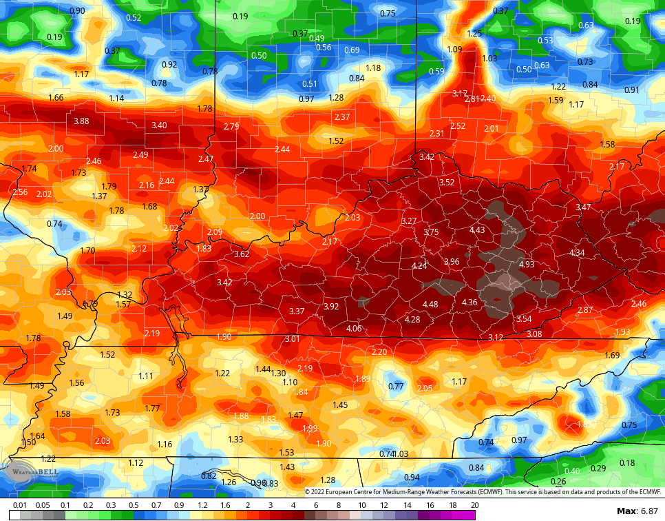
So if we take this same run of the EURO and look a the rainfall numbers, things look ugly. Here are the totals just through Friday…
Now if we expand that to include next weekend, the numbers jump even more…
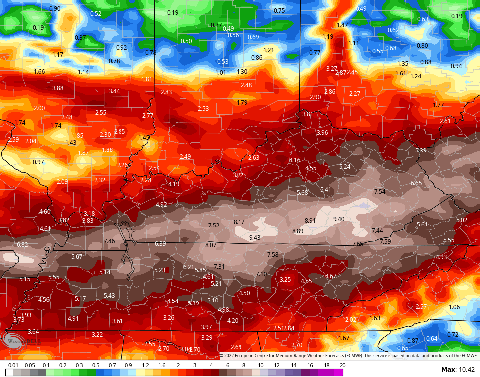
While the totals won’t work out exactly like that, it’s the trend we have to pay attention to. The models are really hitting at a lot of rain over the next week to 10 days and we need to really pay attention to the flash flood potential.
If we look at the longer range from the European Weeklies, we find the wet pattern looking to lock in. Check out how far above normal the 51 member average is from now through September 4th…
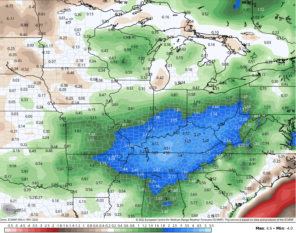
Kentucky is the rainfall bullseye.
Here are your Sunday storm trackers…

Current watches

Possible Watch Areas

Have a great day and take care.

Thanks Chris, weather models trending in the right direction. I hope it pans out and Mother Nature hits the bullseye with lots of rain ( not floods ) to beat this ongoing drought ?
Another early morning of widespread shower and thunderstorm activity for the Chicago Metro Area, but without the severe weather that we saw Saturday morning.
O’Hare Airport recorded 1.77 inches of rain Saturday morning, while the NWS Forecast Office in Romeoville in the SW Suburbs had 1.44 inches.
There were also two confirmed EF-0 tornadoes (with winds of 70+ MPH) in the SW Suburbs early Saturday morning, including one that touched down just five miles north of where I live, which caused numerous reports of tree damage and minor property damage. It was pretty bad here during the storm, with torrential rain, strong winds, and intense thunder and lightning.
Close call Mike with that F0 tornado. I had one touch down December 2021 which was F3 or F4 can’t remember. Less than a mile from my home.
f
as of 11:54 am….Lex Mesonet 85…. Lex airport 89.
NWS out of Louisville plus the Taylor County Airport have been giving false readings on both dewpoints and relative humidity and they pulled the readings altogether including temperature several times in the last week or so. Hope they get this fixed soon.
NWS out of Louisville plus the Taylor County Airport have been giving false readings on both dewpoints and relative humidity and they pulled the readings altogether including temperature several times in the last week or so. Hope they get this fixed soon.
A duplicate on my last comment. clumsy me……..lol
No worries…. I remember a few years ago the KLEX airport was reporting 34 degrees…and I think the mesonet was 31…there shouldn’t have been freezing rain but things were icing up. LOL.. So at that time…it was definitely running warm….but I think those temps got recorded into history anyway. I think they did change it because there were issues…but it seems like it always runs warm no matter what they do.
Satellite Goes East is out on Weather Street except for the entire U S map. Can’t access anyone region. Whats going on ?
Currently my PWS just south of Bowling Green the temperature is 92.3°F. With a Dewpoint reading of 77.4°F, it gives us a Heat Index of 107.0°, which almost feels cooler compared to what I’ve been recording recently.
Almost…
Just checked the 7 day, and it’s the first forecast that did not include at least one day at 90°, in nearly two months! I am so ready for a break.
Here in Maple it’s currently 87 degrees with a heat index of 97 degrees. I’ve been ready for a break since Summer begin.
Me too Schroeder, it be interested how our fall and winter weather will be after this hot summer we have endure. I do remember after that 2012 summer we endure some heavy snow falls from 2012- 13 thru 2017 winters.