Good Tuesday, everyone. Rounds of strong storms continue to rumble across the region for the next several days. With a high amount of tropical moisture in the atmosphere, torrential rains are likely to cause flash flooding issues.
Here’s a quick breakdown of what we can expect:
- A front stalls from west to east across the state as waves of low pressure work along it.
- Rounds of showers and storms will work through the region.
- Some of the storms may be strong or locally severe, but widespread severe is low.
- Damaging wind and hail are the main players.
- The flash flood threat will be elevated and will increase with each wave of thunderstorm action.
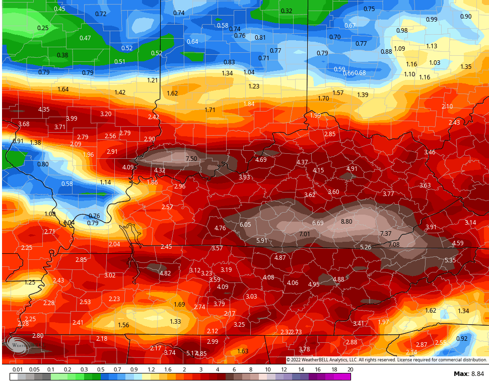
- Rainfall through the week will average 1″-3″ for most of the state with local 5″+ amounts possible.
- After a pleasant break in the action on Saturday, more waves of showers and storms return for Sunday and Monday. This will likely bring another flash flood threat.
- There’s a chance for some big issues to develop somewhere in the region over the next week. 7 day rain totals will be up there, folks!
I mentioned the severe threat is fairly low and the Storm Prediction Center has us in the low-end risk today…

And again for Wednesday…

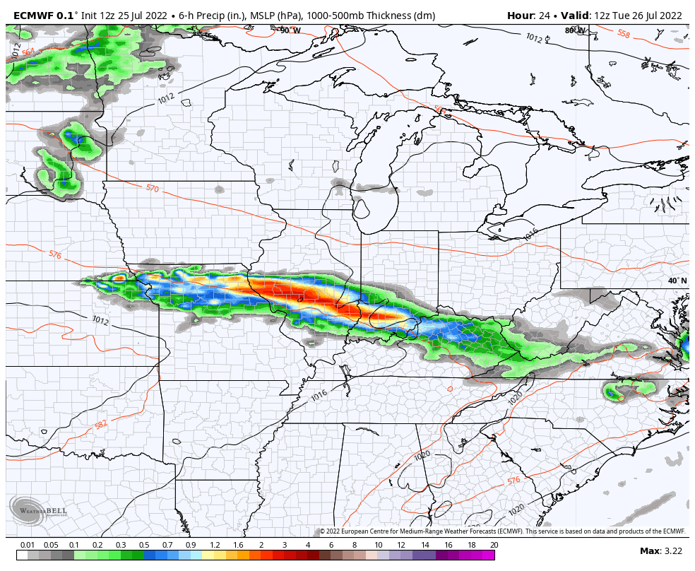
The flood threat continues to be our greatest threat, by far. The EURO offers a great animation of the storm clusters through Friday…
After a brief break, here they crank again late weekend and early next week…
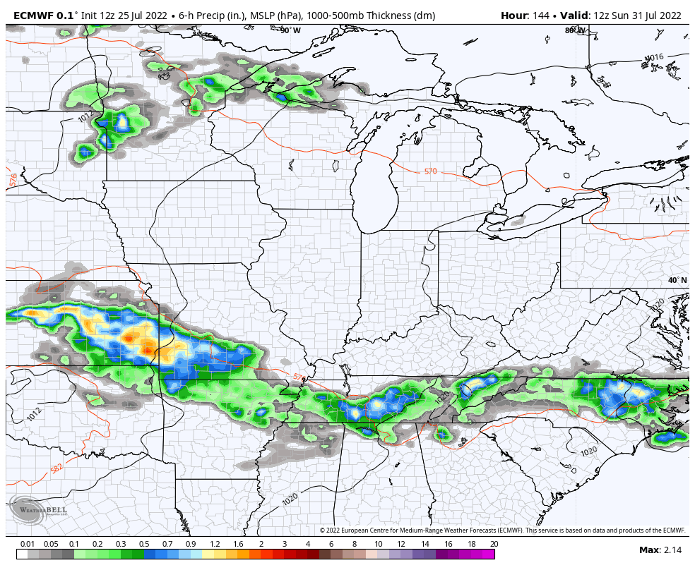
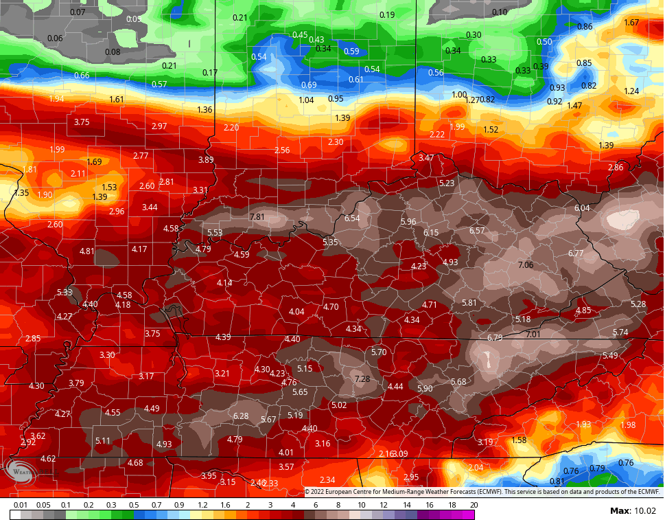
Look at the rain amounts from the EURO through all of this…
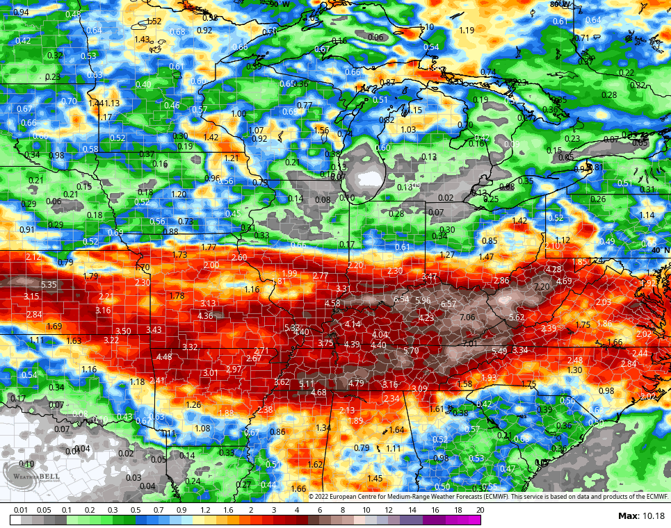
It now has the Canadian as a friend…
That could get ugly, folks.
I will drop by with any updates as needed later today and have the very latest on WKYT-TV starting at 4pm. As always, I leave you with your storm tracking tools…

Current watches

Possible Watch Areas

Have a great day and take care.

On Monday we reached a high of 89°, which was the first day in quite a while where the temperature stayed below 90°. It remained very humid, and with the dewpoint reaching 79°, we ended up with a Heat Index reading of 105°.
Showers and thunderstorms were breaking out all around us, but once again rainfall in our area was extremely light, with only 0.17″ falling during the past 24 hours. The heavier activity stayed to the north and east. Hopefully that stationary front will drop down and stick around long enough to give us some badly needed rain!
We don’t need as much rain as the models forecast.
The various weather models only indicate there’s a chance that some areas may trend towards wetter not necessarily in any given location. Rainfall totals given are the worse case scenario, but be aware. We also had our first day below ninety degrees yesterday and only recorded 0.20 inches of rain showers.
The overall weather pattern has not really changed over the past several weeks. Heavier rains way to my North is continuing. Drought condition are still the major player in the Agriculture industry in my county of Taylor.
Radar returns looking fabulous for people along the river that needed the rain.
I hope the rain will sink south so other communities can get involved.
Wow we’ve had tons of rain in Lexington this morning… but just heavy rain…No thunderstorms.. I feel like it’s been forever since I’ve seen a thunderstorm…
We had a thunderstorm ( small isolated cell ) which only produced thunder and dry lightning. If that lightning hit in the dry fields and pines we would be dealing with a wildfire but, we had a saving shower later that lasted about 10 minutes.
The NWS Storm Damage Team completed their survey of the damage done from early Saturday morning’s tornadoes in the SW Suburbs of Chicago. Three EF-0 tornadoes have been confirmed, with the strongest one having winds of 85 MPH.
Here is the link for the summary of the severe weather and tornadoes, which includes a pretty neat photo of one of the tornadoes developing near Lewis University and the NWS Forecast Office in Romeoville.
https://weather.gov/lot/2022jul2223
At 12:00 Noon CDT it is 84°F at my PWS near Bowling Green, but combined with an extremely muggy dewpoint of 79.2°F, the current heat index is 96.6°F. We have had no drought relief today, aside from the 0.19″ of rain that fell close to midnight.
Maybe I should try washing my car, to see if that would move things along!
We had a puny shower here late this morning but evaporation is exceeding the precipitation. Not good for the field crops. The rain predicted for later, probably won’t be as heavy as they had North of me earlier this morning but we’ll take what we can get.
Interesting Mike, thanks for sharing. I noticed in the report there was some large hail and tree limbs down in your area. The EF0 tornado was at the high end of the scale @ 85 mph. Your lucky that tornado was some distance away.
We has nothing but down pours here in western, ky Union.Co. Hope the ones that needed rain get this.
Looking at the radar a minute ago, looks like the soaking rains are in Southeast Kentucky already. I am thinking now that the ridge is keeping the rains out of our area ?
St, Louis, Missouri, has shattered its all-time rainfall record for one day today. Between midnight and 7 AM Central Time, over 8 inches of rain has fallen, breaking the old record of 6.85 inches set in August of 2015.
And it is still raining there.