Good Wednesday to one and all. Flooding became an issue right on cue Tuesday and, unfortunately, we have a lot more to go through over the next several days. Rounds of thunderstorms continue to move across the region through Friday before a small Saturday break. Storms then return right after that.
Folks, this is a pattern KWC has had you prepped for since early last week. A stalled boundary with tropical humidity surging into it is a no-brainer for heavy rain and flash flooding around here.
Here’s another quick breakdown:
- Rounds of thunderstorms will roll from west to east through Friday.
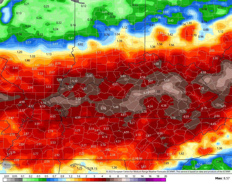
- Another 1″-3″ of rain will be likely with local amounts of 5″+ a good bet. This is additional rainfall on top of what we’ve already had.
- Flash flooding issues are likely. Severe flash flooding issues may also show up.
- A few of the storms may be strong or locally severe during this time.
- Damaging wind and hail continue to be the main players.
Watch how the EURO plays this…
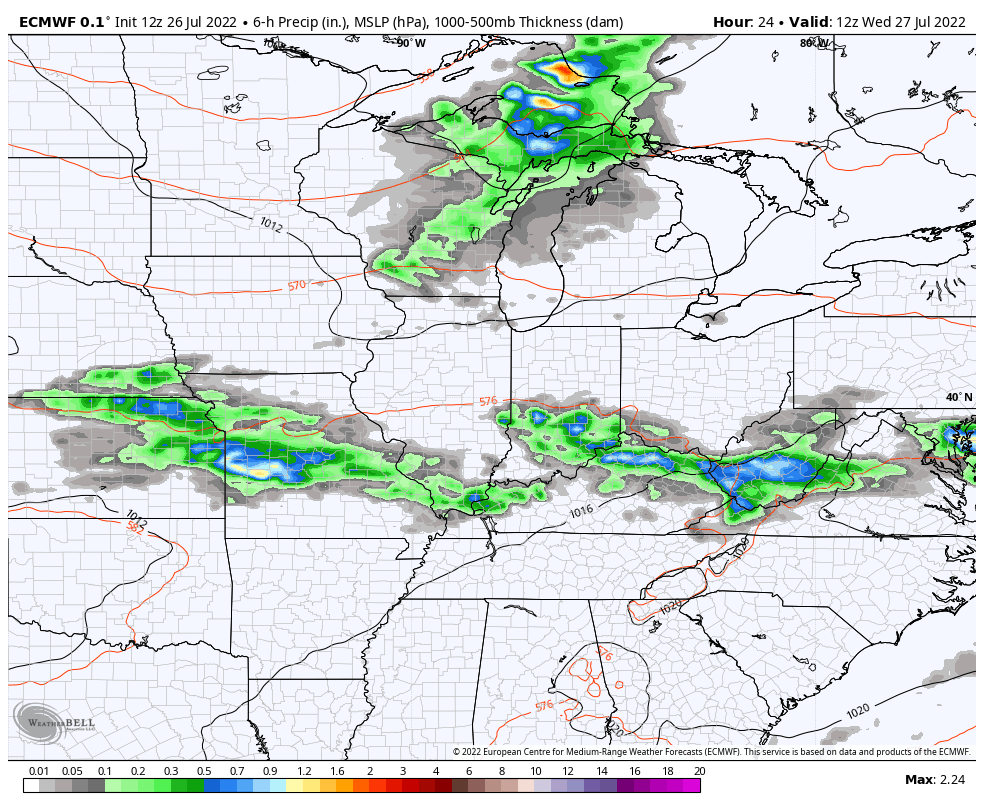
The boundary responsible for the storms sags just to our south on Saturday. That brings comfy air in from the north, but some storms may hang out across the south into the start of the weekend. This boundary then lifts back to the north with heavy rain and storms returning Saturday night through early next week…
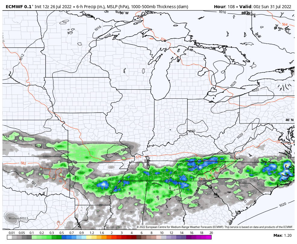
The EURO has been smacking around every other model in terms of the rainfall forecasts. It continues to spit out a lot of additional rain through early next week…
The Canadian continues to trend that same way…
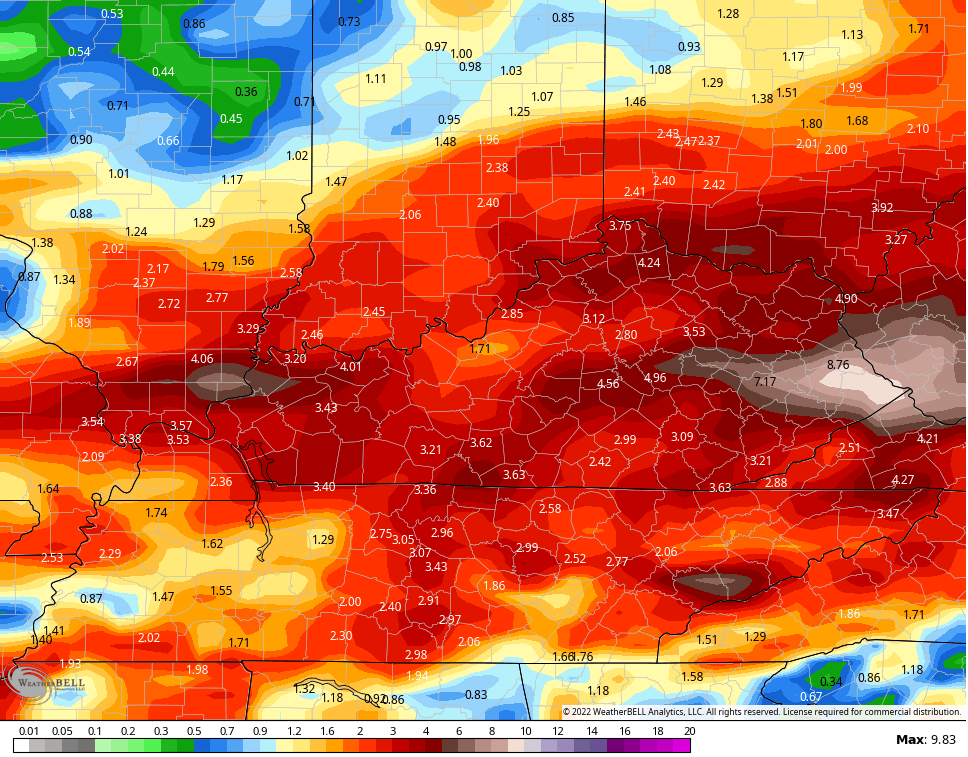
So does the ICON…
![]()
![]()
Significant flash flood events are possible across the region through early next week. Stay alert!
The severe threat is a low-end one and that shows up again today from the Storm Prediction Center…

And once again tomorrow…

I will drop by with any updates as needed later today and have the very latest on WKYT-TV starting at 4pm. As always, I leave you with your storm tracking tools…

Current watches

Possible Watch Areas

Have a great Wednesday and take care.

Thanks Chris, only 0.29 inches of rain recorded for Taylor County in the past 48 hours according to the mesonet. We’ll take it hoping for more later ?
The majority of the rain this morning is staying north of the river.
Bad news for some of the folks who need the rain.
Bowling Green and vicinity are still high and very dry. Over the past 2½ days I’ve recorded only 0.19″ of rain. All of the meaningful precip is to our north and east. During the past 25 minutes, several large clusters of storms have formed roughly between Hopkinsville and Russellville, moving east, but odds are that as they approach Warren County, they’ll either turn northeast or dissipate. There is no activity in the tropical Atlantic, the Caribbean , or the Gulf of Mexico. In the Eastern Pacific, tropical storm and a wave are the only active area.
I don’t know any rain dances, so I’ll stick with the tried and true “wash the car” gambit.
I believe the stationary front is forecasted to sink south before headed back to the north.
Hopefully, this will give you a better opportunity to receive some badly needed rain.
Without question it will be a welcome relief!
As predicted, part of that line of storms dissipated, the rest curved to northeast and away from Bowling Green…
We currently have a nice thundershower here in Maple.
Schroeder, that’s part of the line of storms that avoided Bowling Green like the plague
A lot of scattered showers have developed over the last hour. You still have that chance of receiving some ?