Good Friday, folks. We continue to track rounds of showers and thunderstorms as they drench the Commonwealth once again. The action today into early Saturday is likely to cause more flash flooding issues with another threat lurking early next week.
It took a bit of nudging, but the Flood Watch now includes almost all of Kentucky through this evening…
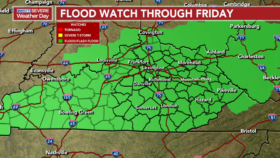
That will likely get extended through tonight and maybe into Saturday.
Here’s the area I’m most concerned with for more flash flooding…
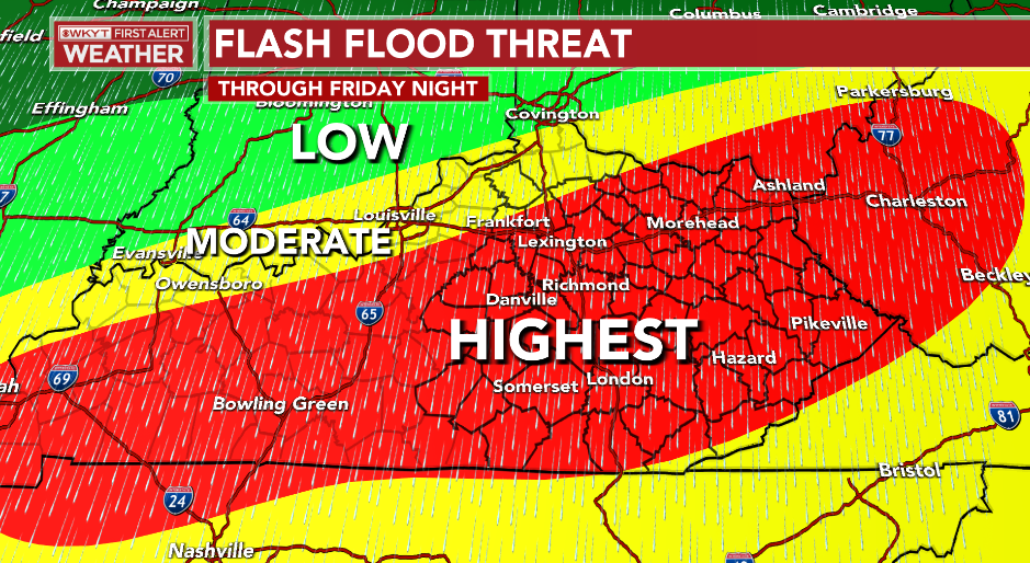
Many of us will pick up another 1″-3″ of rain through Saturday with local amounts of 4″+ possible. That would be more than enough to cause additional flash flooding issues to develop.
You can see these waves of showers and storms on the EURO…

That animation goes through Sunday night and shows how the action becomes much more scattered by Sunday.
That “scattered” trend takes us into Monday before another system drops back in from the northwest by Tuesday and Wednesday. That brings more widespread showers and storms that can lead to additional high water concerns…

This is also a pattern that skews cooler than normal on the EURO…
I leave you with your shower and storm trackers on this Friday…

Make it a great day and take care.

At least our temperatures are getting back to normal for next week ? Our last significant rain event in my county was late Sunday afternoon and now it’s beginning to dry out. The crops may need rain soon before the plants mature for harvest later this Fall.
Surface Sea Temperatures in the Gulf of Alaska remain well below normal but, there may be some signs of warming trying to move back into these Northern Regions of the Pacific Ocean ?
Hoping the flooding potential doesn’t turn out to become another reality in areas of the State that have already received record rainfall and destructive flooding ?
The latest SST Anomaly charts show that below normal sea surface temperature anomalies in the central Pacific are strengthening, while there has been some weakening off the coast of S. America. A recent report indicates that La Nińa effects will weaken over the next couple of months, but strengthening will be likely during late Fall and early/mid-Winter. The report predicts that the odds for a neutral ENSO will increase during the late Winter/early Spring 2023 period.
https://www.google.com/url?sa=t&source=web&rct=j&url=https://www.cpc.ncep.noaa.gov/products/analysis_monitoring/lanina/enso_evolution-status-fcsts-web.pdf&ved=2ahUKEwjVzOXs0q_5AhVRK0QIHSd6CdgQFnoECAwQAQ&usg=AOvVaw3rCcwu_4T330uvE2KxcqE1
The most recent Sea Surface Temperature Anomaly chart shows that temperatures close to the Alaskan coast are moderate, however, the chart indicates significantly warmer temperatures in the southern Gulf of Alaska, and moderately warmer in the Bering Sea. If they persist, it increases the likelihood of a northern displacement of the Polar Jetstream over Alaska, and a dip in the Polar Jet over Canada this Winter.
That’s a BIG if!
https://www.ospo.noaa.gov/Products/ocean/sst/anomaly/
Takes for sharing Joe, I booked mark each presentations. I’ve been looking at an old presentation on the Surface Sea Temperatures in the Pacific. I stand corrected.
No worries, Schroeder, I also keep those sites bookmarked! The thing that gets me about the SSTA map is the intensity of the water temperature in the southern Gulf of Alaska, well beyond what we’ve seen in recent years. Also, notice how warm the waters are in the Northwestern Pacific and the Sea of Japan. Since the prevailing currents move west to east, it could possibly replenish or expand warmer water into the rest of the Gulf of Alaska.
One last point: if one of those traditional late season super typhoons takes a track towards Japan, as they often do, all of that warmer than normal water around the Sea of Japan and the Northwestern Pacific could cause unprecedented intensification.
Yeah, whatever happens with SST in the Gulf of Alaska will determine what our Fall and Winter will be in the Ohio Valley. In 1977- 78, Alaska had a very mild Fall and Winter while we were just the opposite. ENSO plays a huge part in this of course along with the PDO going positive along with a negative AO and NAO.
On Thursday afternoon, widely scattered, fast-moving thunderstorms developed over the Chicago area, causing numerous Severe Thunderstorm Warnings and localized winds of 60-70 MPH, with extensive tree damage in some areas, while other areas barely received a drop of rain.
Here is the link for the summary of the event from the NWS: https://weather.gov/lot/2022aug03
Actually, it was Wednesday afternoon that this occurred… my bad.
Mike, here in Maple we have escaped any severe thunderstorms so far. It has rained more today than it has all week.