Good Sunday to one and all. As we get set to put the wraps on the weekend, it’s time to really focus on changes for the week ahead. Those changes include a more active pattern with some honest to goodness rain chances. I’ll also take a longer range look into fall and early winter.
Let’s start with today and hit the fast-forward button. Highs are back into the 70s with a strong southwesterly wind gusting to 25mph at times.
Monday features pretty much the exact same forecast, so let’s abide by all local burn bans and restrictions.
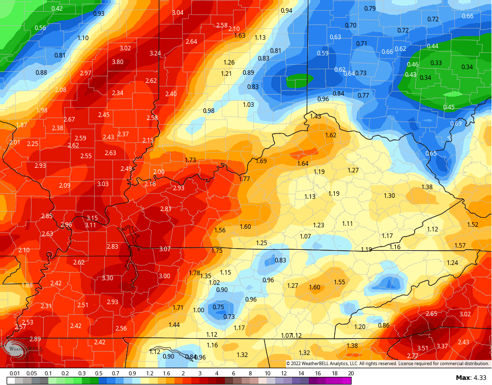
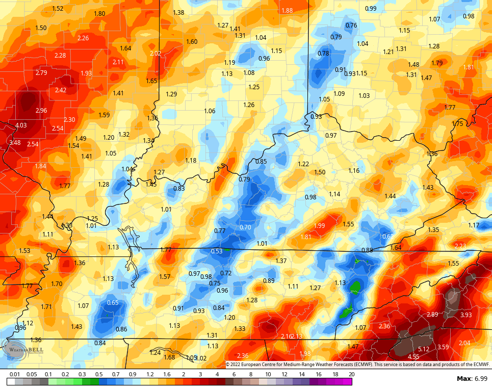
A slow-moving storm system moves in here late Tuesday and Wednesday. This brings showers and a few thunderstorms sweeping in from southwest to northeast…

Given the strength and positioning of the low, there’s even a low-end threat for a few strong to severe storms in the west on Tuesday. Here’s the Severe Weather Outlook from the Storm Prediction Center…

Gusty winds will be common with any shower or storm that goes up during this time.
Seasonably chilly winds blow in behind this for Wednesday and Thursday as we focus on another system for Halloween Weekend. That one doesn’t look as strong, but can still bring some showers and storms in here…

The models are spitting out some really nice rain amounts from these two systems, but it’s still early in the game…
CANADIAN
EURO
The latest run of the EURO Weeklies continues to show the increasing potential for a trough to develop across our region for November. You can see this on the 30 day 500mb height anomaly map that runs November 4-December4…
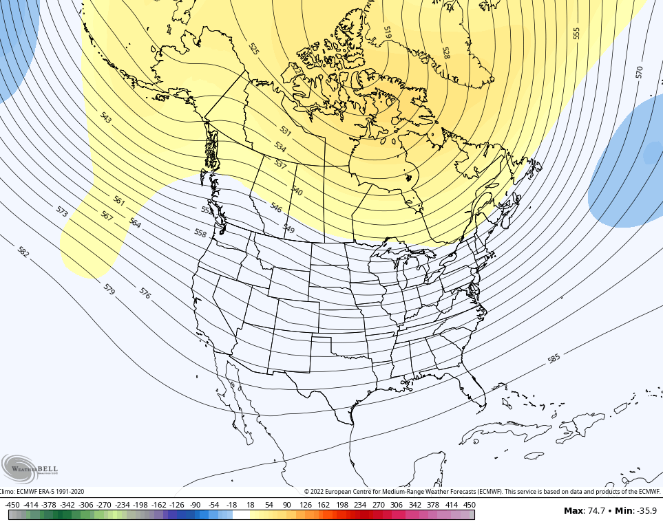
That kind of setup would give us an above average chance at below normal temps, with some pretty good cold shots on the table. The model does give us more snow chances through December 4th…
That looks like an early start to winter to me.
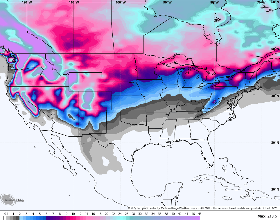
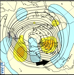
The latest run from the JMA model for the 2 week period in the middle of November also shows a trough developing in the east and southeast…
Have a great Sunday and take care.

Well they finally take a deep dive into the Lexington KLEX thermometer debacle if anyone wants to watch
https://www.youtube.com/watch?v=Sd9JhBjaJGw&t=7s
OK so I finished watching this….My thoughts….
I didn’t learn anything really…Every reason for the temp difference was what I already suspected….the airport location of the ASOS vs the other comparison locations are located in fields.. The only thing that I did learn was that the thermometer was in full sun….I’ve always thought actual temp readings were to be taken in the shade. Is that true? I’m glad he brought up the differences in full sun days vs cloudy days and that it’s the temperatures are closer in winter and during the nights. I think the take away from this is that airports are not a good location for these instruments to be located (at least for me)…but it’s required by the FAA that they be located at airports (I did not know this… until this video)
When I was in the nursery / landscaping business I placed my recording thermometers in the shade and in full exposure just to see the difference. Airport readings where I lived were always different from my reading. I now have one radio controlled thermometer off my porch out of the sun’s exposure and it doesn’t match the Kentucky Mesonet’s readings either. Temperatures are different in any location. I now just use the Mesonet readings. Just the other morning I had 35 degrees and the Mesonet had 21 degrees. Which reading is correct ? Thanks Mark for posting the Video on Lexington’s airport temperature readings and their thermometer placements.
Thanks Chris, strongest troughs are in the West and systems are phasing causing much needed rains and mountain snows in those drought stricken areas. That’s great for those areas. As they move east they are forecast to weaken before reaching the Ohio Valley. How much worse is this drought going to be in our area ?
Is the tropics still active ? Is it a La Nina drought ? Is it the southeast ridge ? This has been a most confusing year of weather with no clear answers as to what’s happening.
The upcoming system is not going to fix our drought woes.
But it might be a start.
I just checked for precipitation chances for next week and there is only 0.30 ” on Wednesday. Like you stated ” it’s a start. ” Looks like that third La Nina is kicking in with a lot of warm, windy and dry weather like our neighbors to our south. This drought could last longer ? It’s getting serious when your well or spring is drying up. If the NAO would really go very negative late next month it would override this phase of ENSO.