Good Wednesday to one and all. We have two more nice weather days before a major pattern change settles in. Heavy rain is looking more and more likely for Friday as we get set for wintertime temps to crash in behind it this weekend.
Temps today and Thursday are into the 70-75 degree range for many. Soak it up, folks.
Nicole is likely a hurricane by the time you’re reading this. Take a look at how this storm is really coming together as it gets closer to Florida…

This should make landfall tonight as it then turns northwestward and may even emerge over the Gulf for a small time. From there, Nicole heads northward and what’s left of it likely works up the eastern slopes of the Appalachian Mountains. Here’s the latest information on Nicole and the latest track forecast from the National Hurricane Center…

This track continues to be one that will put down heavy rain for much of eastern Kentucky and some of that gets into central parts of the state…
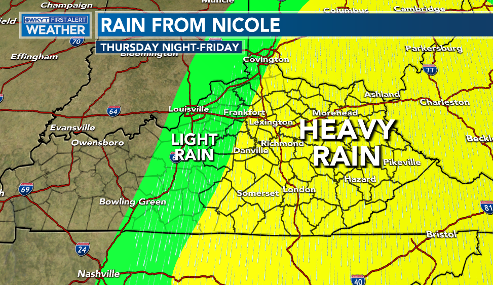
A general 1″-3″ rainfall is likely across the eastern half of the state. With the majority of that coming in under a 12 hour period, I can’t even rule out local high water issues developing. What?! That’s how we roll, folks.
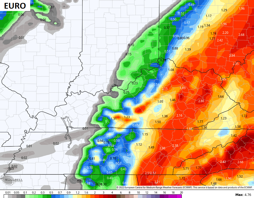
Check out the rain totals from the forecast models…


![]()
![]()
You know about the cold air coming in behind that for the weekend… It’s frigid and will be a shock to the system. There’s an outside chance for a few snowflakes to fly on that northwest flow later Saturday.
The setup for next week continues to have an interesting look as additional cold shots dive in here. Energy could be coming from the southwest Tuesday and Wednesday as one of these shots of cold blows in. This would bring the threat for rain and snow in here. The models are beginning to see this threat a little better as we get closer…
GFS

CANADIAN

EURO

I will have another update for you later today. Have a good one and take care.

with all this rain coming in so late will this set us up for a cold and snowy winter
I really don’t know how this coming Winter will unfold. I wish all the Snow Lovers lots of Snow and cold. For me I’ve seen enough.
It looks like Nicole and her badly needed rain shield will miss the South-Central Kentucky region. Also, the NWS has issued an “Elevated Risk of Fire Danger” for all of Central Kentucky and Southern Indiana today. This includes the cities of Bowling Green, Lexington, Louisville, and the surrounding counties. With temperatures forecasted near 80° today, relative humidity levels in the 25-30 % range, and a supply of very dry fuel throughout the region, the risk of brush fires is extremely high, so please report any fires nearby to authorities in you area as quickly as possible!
Driest I’ve seen since the late 1980’s. Good advice Joe. I think in my area everyone is being watchful for any
wildfires that may breakout.
I thought about you when I saw that rain shield pretty much totally missing your area….but maybe it will trend a little west…
I’m hoping Chris’s forecast pans out. Nice day to be out and about. Looking forward to a change with either rain or snow later in the week.