Good Saturday, everyone. It’s a super wintry day taking place across the region today as a wave of low pressure zips through the Ohio Valley. This is bringing rain and snow with a pocket of sleet even possible. Oh, and there’s another wintry system coming behind it by Tuesday.
A few thoughts on today’s system:
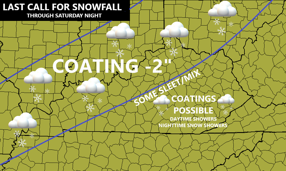
- A swath of light to moderate snow streaks across western Kentucky and then northeast toward northern parts of the state.
- That area can pick up a coating to 2″ of snow with most of that on grassy and elevated surfaces. This more of a novelty than anything and whatever falls may not last very long, so catch it while you can.
- Areas of southern and eastern Kentucky will mainly see a cold rain before ending as a light mix.
- The buffer zone in between likely has a bit of a mix and even some sleet.
- Northwest winds kick in late this afternoon through tonight and that should bring snow showers and flurries to the eastern half of the state.
Here’s a look at the Last Call For Snowfall…
In terms of the snow shower and flurry potential tonight. You can see this action on these future radars…
NAM

HI RES NAM

The next storm system rolls in Monday night and Tuesday and looks like another messy one. This may bring rain and snow back into our part of the world and this is just getting to the end range of the NAM. Here’s the future radar from 7pm Monday-7am Tuesday…

That may be followed by some snow showers and flurries for Wednesday and Thursday. We will need to watch for another system arriving late next week or into the weekend as another massive trough takes hold…

Check out that massive block in Alaska and the Yukon!
I will update things later today. I leave you with all the winter tracking tools you need for the day…

LEXINGTON


LOUISVILLE


COVINGTON AREA


FRANKFORT


GEORGETOWN

BOWLING GREEN


PADUCAH

E-TOWN

MAYSVILLE

Don’t forget to check out the weathercams page for additional cams from across the state. Have a sensational snowy Saturday and take care.

cmon man where are the bloggers at, its 5am!!!!!
Thanks Chris, More November like this morning with a temperature of 43 degrees and a cold light rain falling. I ended up with 0.73 inches of rain yesterday. A good beginning to combat this ongoing drought. Tomorrow I turn 71 years old, but I feel like I’m 81 years old. Two bouts of Covid plus the two strokes later really did a number on my health.
Hope the Snow Lovers enjoy their first Snowflakes. Some sleet and cold rain is forecast in my area of Taylor county with a slight chance of Snow flurries later.
Happy Birthday, Schroeder. I turn 71 in early February but aside from a bruising round with influenza eight weeks ago, we’re both in good shape. Our plants need every drop as the roots take up moisture before the ground freezes. I’m feeling better about all that. Around here, we may have extended dry spells which do damage, but eventually the precipitation we need arrives (at least in Fayette County).
Many happy returns, Schroeder!
It’s snowing hard here in western ky about an inch or two on ground. Don’t recall having this much snow this early in my lifetime
Happy Birthday, Schroeder and welcome to the 71 club. There are no dues, and every day is one of discovery: Discovery a new ache, discover a new pain, etc!
Right now the temperature at my PWS is 32°F, which is also the low for the day, and is 26° colder than it was the same time yesterday. The precip. has cleared the BG area, and it did so without mixing with/changing to sleet or snow. We did pick up 0.13″ of rain overnight.
The Arctic and North Atlantic Oscillations are both expected to trend neutral to positive over the next two weeks, but the intense ridging over the northwest and Alaska will give us colder conditions than those two signals would imply. Judah Cohen also feels that conditions are beginning to favor Polar Vortex stretching as early as the beginning of December.
Happy BD. Schroeder, I picked up around an inch of snow this morning. Not a drought buster but I will take it.
Happy Birthday Schroeder
Thanks everyone for the birthday wishes ! I was surprise that we didn’t receive a flake of Snow here this morning. We had rain all morning which is Okay by me. All moisture in any form except for freezing rain is most welcome.
HAPPY BDAY SCHROEDER! not even a flake of snow here in fayette county and dont look like there will be. Things must be getting back to the old normal when Lex misses out right at the finish line. Congrats western Ky ..