Good Monday, everyone. It’s a brand new work week as we continue to see a wintertime pattern lock in across our part of the world. This pattern throws another light rain and light snow maker at us over the next couple of days with more frigid air to follow.
Temps out there today will hit 40-45 degrees and this is likely the warmest high temp of the week. A mix of sun and clouds will be noted before overcast skies slowly take control from the west and southwest late today into this evening.
Those clouds are ahead of an approaching storm system sweeping in later tonight and Tuesday. This will likely bring light rain and some light snow to the state during this time. The precipitation looks fairly light and the best chance of seeing flakes will be for some of the same areas that saw snow over the weekend.
I’m also going to be watching to see if a sneaky period of light freezing rain or sleet shows up.
This shows up on the future radar of the Hi Res NAM. Our animation goes from Midnight tonight through 7am Wednesday…

You can also see some snow showers and flurries showing up behind all that by Wednesday morning. That’s ahead of a piece of energy swinging in here later in the day through early Thursday. That’s likely to spit out some streaks of light snow and flurries. The future radar from the NAM shows these streaks…

Some light accumulations will be possible with that setup. Light is the key word.
Those two runs are showing what the Canadian has been showing for a while now, and it continues to do so…

Reinforcing cold air surges in behind that for the end of the week and into the upcoming weekend. Wind chills are likely to be crazy cold. Check out these animations that run from 7am Friday through 7am Sunday…
GFS

CANADIAN

This cold is so strong that it crushes any southern storm track, but it’s one we may have to watch the northwestern fly for a clipper looking system.
Thanksgiving Week will likely see the extreme cold moderate for a few days to start with another cold blast coming over Thanksgiving weekend. We might even get a storm system to develop in the transition window.
Let’s look even farther down the road with the GFS Extended. The model run goes through the middle of December and is showing a similar configuration to the jet stream in the overall means. Check out the average height departures for this 30 day period…
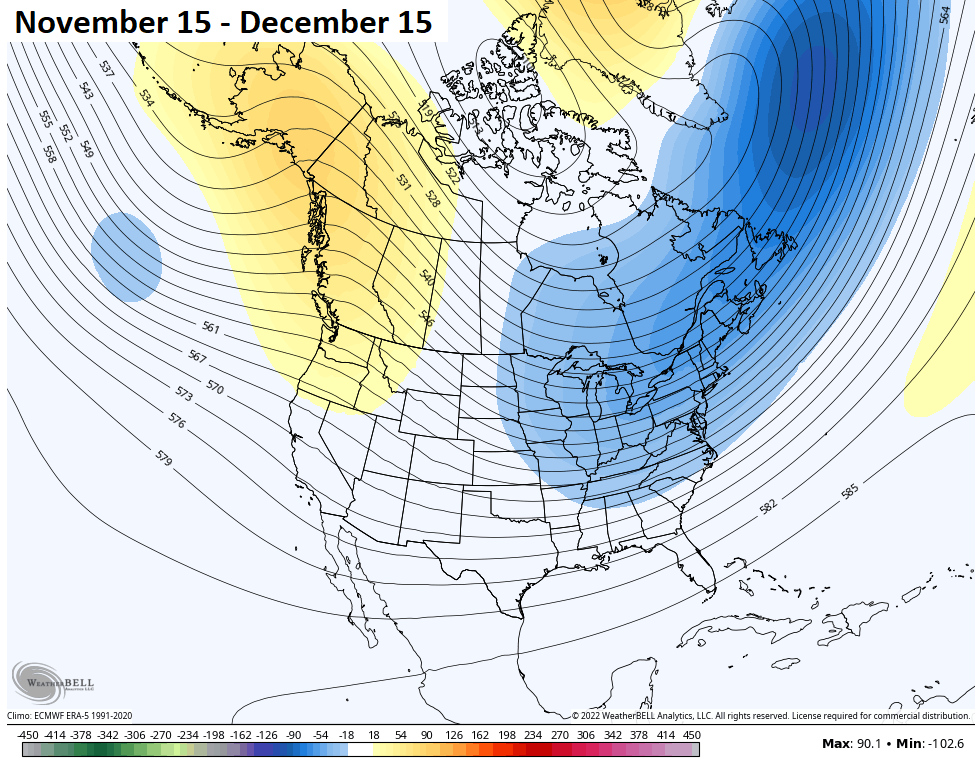
I like seeing that ridge into Alaska!
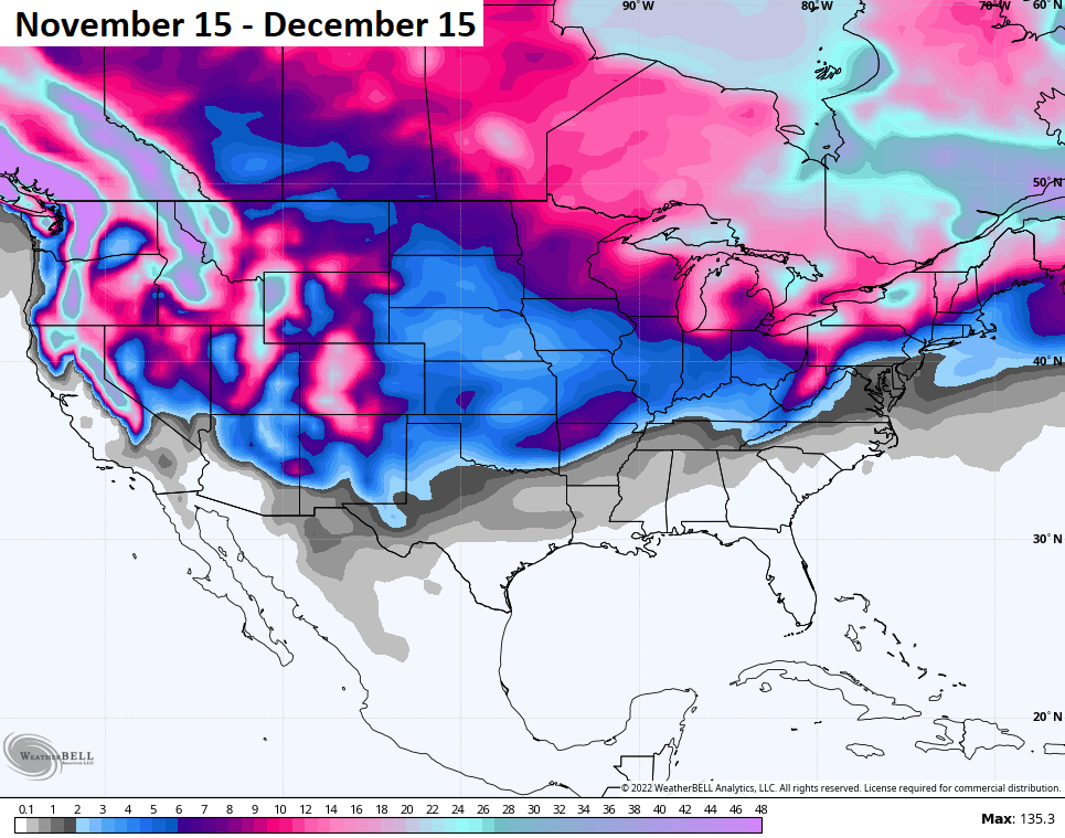
With cold like that, the model produces snow chances…
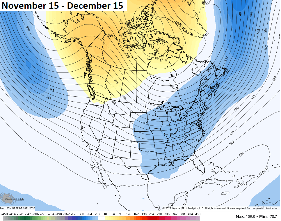
The CFS seasonal model during the same period has a similar looking 500mb looking pattern…
Of course, that doesn’t mean we won’t get some ridges in here from time to time. That’s just showing the average for a 30 day period.
I will have updates later today, so check back. Have a magnificent Monday and take care.

Thanks Chris, yeah, I agree one needs breaks from the frigid cold and Winter weather systems from time to time.
I like to see more sun from time to time.
It has been gloomy over the last few days in my region.
Looks like it’s going to be Sunny today, but maybe some increase in clouds later this afternoon ahead of our next weather maker. The forecast for my area tonight and tomorrow calls for a 70% chance of rain. Hoping it warms up enough for it to be just plain rain and not ice.
It’s sure nice seeing the sunshine after that cold weekend. Schroeder, we did get our deer for the freezer but when we got home to SE Lexington, our neighbor showed us a picture of a buck that was in our driveway yesterday morning! How crazy was that!
Dottie, Glad to here you and your Husband were successful in harvesting a Deer. Isn’t that the way it is, you come home to find out there was a Deer standing in your driveway. LOL…..
Overnight low here at my PWS in central Warren County was 24.1 °F As I had mentioned a few times before, the Arctic jet stream is being influenced by that warmer thn normal water in the Northern Pacific, pushing the jet farther north. It’s one reason why the current temperaturein Anchorage, Alaska is40°F! That repositioning of the jet stream puts the central US in the path of the downward leg. That’s pulling air from Northern Canada into our neck of the woods, and forcing the storm track much further south.
Great meteorological information Joe. I just hope it doesn’t loosen a lot of that Arctic air and bring our temperatures down way below zero. With the jet stream being further South, our area of South Central Kentucky may receive some that accumulating Snow, but that 540 line must stay South of our area so we won’t be in a freezing rain event like the 2009 ice storm.
I think I feel a very slight, but definitely distinct, tremor, maybe rumble, coming from what i suspect is the Polar Express……put on those winter travelling clothes and settle in for a lovely ride! Go Team 540*!