Good afternoon, folks. Snow flurries are winding down as we get set for another cold front to blast the Bluegrass state tonight and early Friday. This brings some incredibly cold wind chills in here for the upcoming weekend.
Most areas got in on some light accumulations of snow overnight and early this morning. With low clouds lingering, some flurries have been hanging tough, but this action should wind down this afternoon.
Not that they will show much, but here are your radars for the fun of it…

One more batch of light snow and flurries will show up late tonight and early Friday as another cold front sweeps through. That ushers in the big time cold for the weekend. Check out the wind chills from 7pm Friday through 7am Saturday on the Hi Res NAM…

The GFS shows Sunday morning wind chills going a few degrees lower than Saturday…
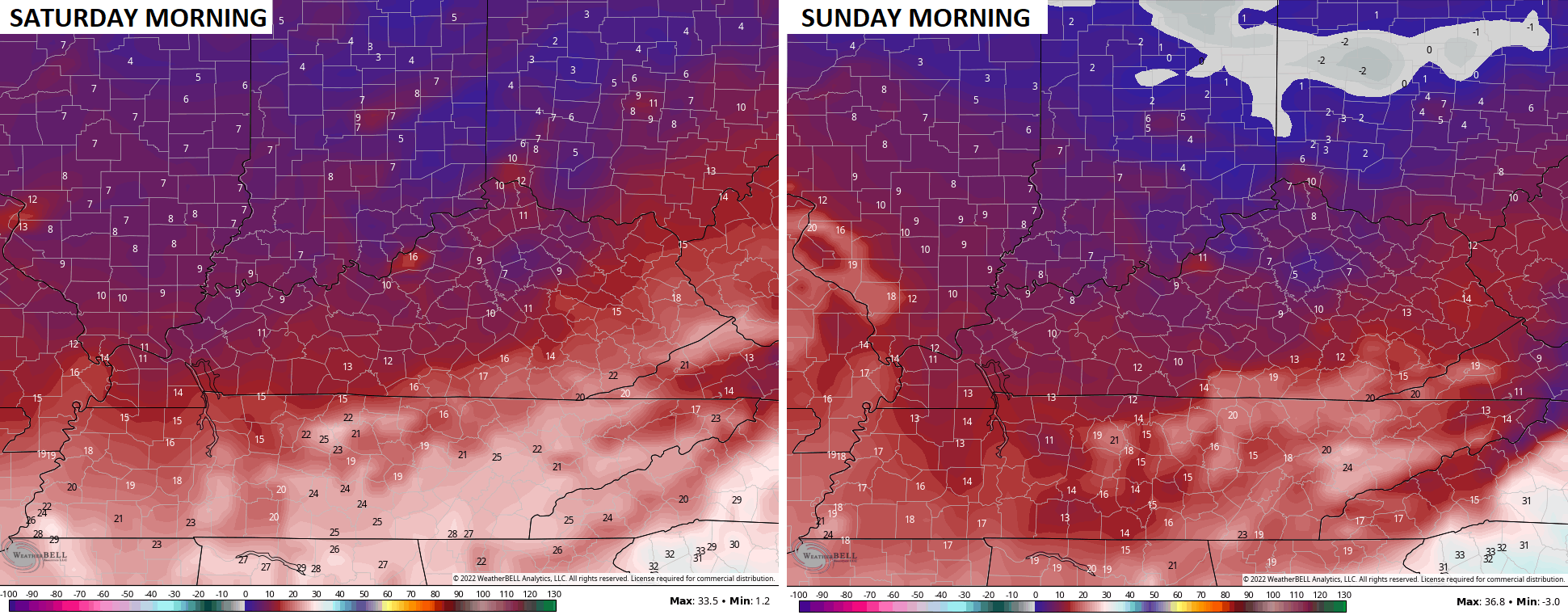
Single digit wind chills before Thanksgiving isn’t a common thing, folks.
Speaking of Thanksgiving, I continue to track the chance for a big storm system to develop across the eastern part of the country. It’s a setup that has the looks of wet and windy to start, with some flakes and cold to end.
The models continue to have issues from run to run, but the latest GFS is trying to get much more of a phased looking system to develop. Check out this big bowling ball upstairs…

Here’s the current look at the surface from that same run…

You can see how the initial system is actually coming from the northern stream before handing off energy to a more significant east coast storm system.
As I’ve said, expect lots of different looks from the models for a few more days.
Don’t forget, the winter forecast is tonight at 6 on WKYT-TV. Be there or you’ll get zero snow this winter. 😉
Have a great afternoon and take care.

So if I don’t watch, I won’t get snow? Hmmmm, I never miss the 6 oclock news, but……
I don’t like snow.
So as I live in Northern Kentucky (Go Norse) no snow for me, yay!
But as I always watch the replay on wkyt.com I guess that counts too.
I plan on watching Chris’s outlook for the Winter, but I probably won’t receive any Snowstorms this Winter worth writing home about. I actually dread this Winter because of La Nina, which usually brings us severe weather ( high tornado potential ) and ice storms.
Just the mention of the possibility of an ice storm sets my anxiety level to high. I sure hope we don’t have any of that this winter.
I’m sorry Dottie I forgot that you were afraid of Ice storms. I’m also scared of Ice storms and now Tornadoes after last years outbreak in my area.