Good Sunday to one and all. Our much talked about potent storm system is rolling across the state today and it’s bringing high winds and heavy rain. This system continues to be part of a very active setup to close November and begin December.
This will likely unleash some severe cold into the country and I’ll get into all that coming up in a bit.
Let’s begin with today’s wild weather. Winds are gusting between 40mph and 50mph at times, especially through the noon hour. Winds slowly calm down after that, but expect gusts to still be in the 30mph-40mph range to close out the afternoon. Wind damage and power hits are a good bet.
Gusty showers and an early morning rumble of thunder continue to be likely today. Here are your radars to track the spiraling rounds of rain…

Lingering showers continue tonight into Monday as seasonably chilly high temps show up to start the new week…
 Southwest winds kick on for Tuesday ahead of another big time storm. This low pressure works from the Plains toward the Great Lakes Tuesday night and Wednesday. This makes for a wild setup to close out the month of November. Some headlines for it:
- Highs Tuesday soar into the 60s on that strong southwest wind.
- Scattered showers and storms develop during the afternoon and evening from west to east.
- Tuesday night into early Wednesday looks active with high winds and thunderstorms sweeping eastward.
- Some of the storms may be strong, especially in the west.
- Wind gusts to 50mph will be possible along and just ahead of our cold front early Wednesday.
- Temps start Wednesday in the upper 50s to low 60s then crash quickly from west to east.
- Thermometers drop into the 30s just behind the front and then wind up near 20 degrees Wednesday night.
- Wind chills will be a big player and hit the teens to start December on Thursday morning.
- There’s a chance for some festive flakes to fly right behind the front.
Here’s a look at the progress of our system…

The timing of the front sweeping through here is just a bit slower on the GFS compared to other models. These animations for the “feels like” temps run from 7am Wednesday through 7am Thursday.
GFS

EURO
 CANADIAN

That cold doesn’t hold as temps look to rebound quickly by Friday into the weekend. It could turn a bit mild again before the cold slowly starts to flex.
Since late in summer, I singled out the years of 2000, 2010 and 2020 as my primary analogs for this upcoming winter. All three of those started winter off with a bang in December and I’ve been onboard with a similar scenario playing out this December. The major cold shots we’ve had this fall, to me, have telegraphed where this pattern is going.
I’ve targeted the middle of December for the potential of big time cold settling into our region and the country and the various signals I look at are now signaling this potential.
We are seeing all Ensembles going toward significant blocking with a -AO, -EPO and -NAO taking place at the same time…
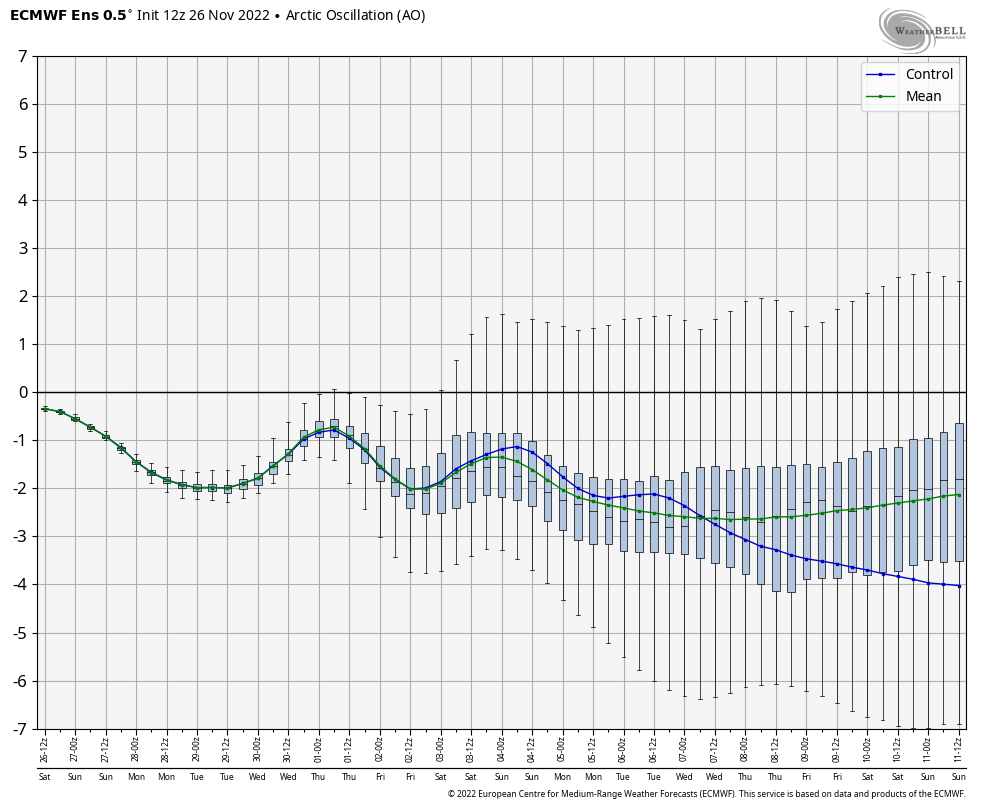
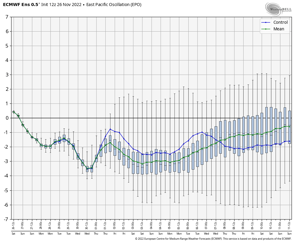
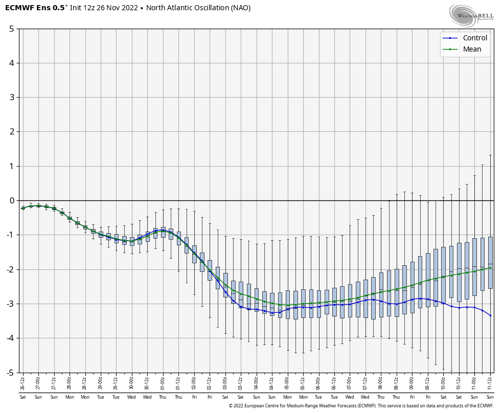
One of those indices going negative would be a good sign for some cold weather chances in our part of the world. To get three of those to all tank at the same time is an attention getter. Here’s what this looks like…
GFS ENSEMBLES centered on December 7th…
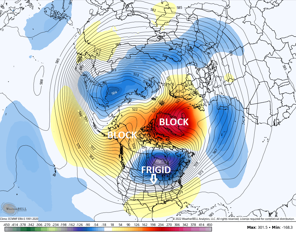
The EURO Ensembles for that same time…
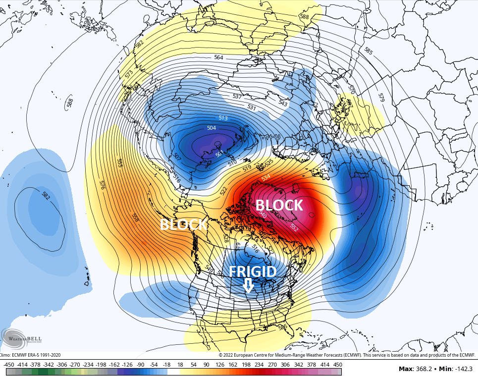
Those two look pretty much identical and would force much colder than normal air deep into the country…

It’s very impressive to see those types of temp departures showing up from this far away and on a smoothed out Ensembles mean.
Now, what about snow chances? You can’t have snow without the cold, so that’s certainly a good start. One thing to watch for is that southeastern ridge putting up a fight and setting up a very active storm track on the edge of the serious cold. While that could be good for winter weather lovers, it could also pose a problem if it’s too strong.
I’ll drop by for updates later today. Have a great Sunday and take care.

wake up americaaaaaaaaaaaaaaaaaa
In the Bowling Green area we picked up 0.51″ of rain over the past 24 hours. Winds have been gusty since about 4:00 am, with the peak gust clocking in at 40 mph.
I’m a bit concerned about the storms on Wednesday, since that strong cold front will be coupled with a SW to NE mid-level jet stream, which could increase shear potential, and initiate isolated supercells in Western and extreme Southern Kentucky.
With the AO, EPO and NAO all projected to go negative, we could be looking at some intense cold in our area, and unlike the typical up and down action ober a couple of days, this cold could establish itself for a couple of weeks.
…”over” a couple of weeks
!