Good Tuesday, everybody. We have a rather active weather day taking shape across the region as a strong cold front plows in from the west. This brings the threat for strong to severe storms, high winds and a big temp crash. Let’s get ready to rumble!
Here’s a quick breakdown of how this system likely plays out…
- Gusty southwest winds boost today’s temps into the 60s.
- Showers and storms develop this afternoon in the west and roll eastward this evening and overnight.
- Some of these storms may be strong to severe, with the best chance across the western half of the state.
- Damaging wind is the main threat, but there’s a low tornado risk in the west.
- With or without thunderstorms, winds gusting to 50mph or greater will be possible tonight and early Wednesday.
- The cold front races in overnight with crashing temps behind it. Readings go from around 60 ahead of it, to the upper 30s behind it.
- Wednesday night lows drop close to 20 with a wind chill making it feel like the teens.
- Day one of December on Thursday looks seasonably cold with highs in the upper 30s and low 40s.
Here’s the latest Severe Weather Outlook for today from the Storm Prediction Center…

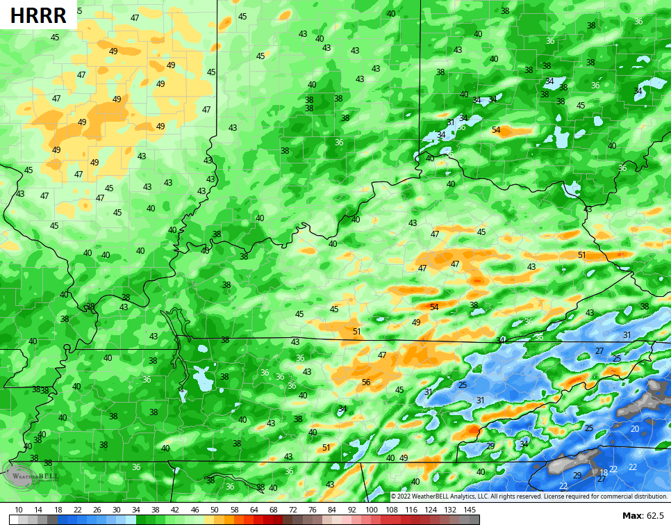
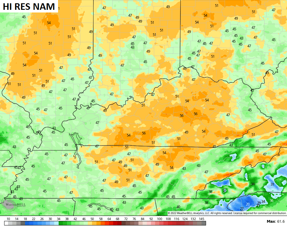
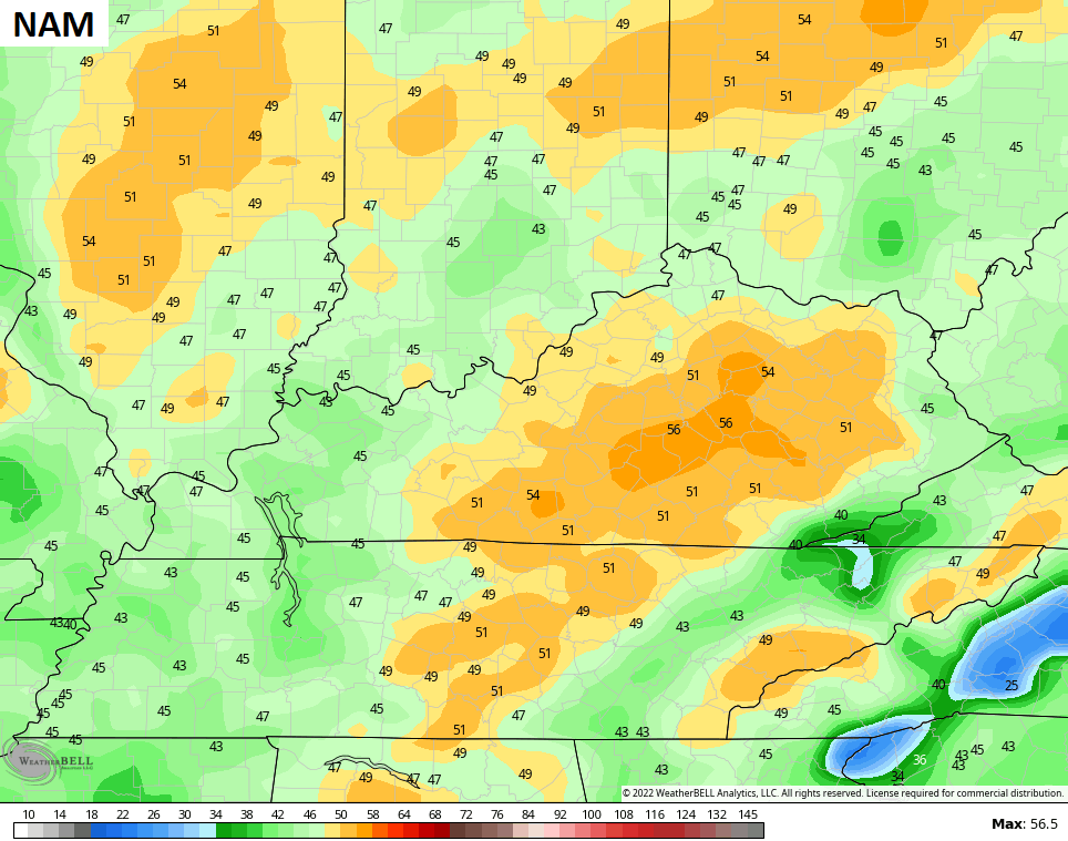
Check out some of the peak wind gust forecasts from the models…
Let’s play a game of “find the front” on the hour by hour feels like forecast…

Another cold front arrives on the scene Friday night and Saturday with some gusty showers…

That boundary slows down across the region allowing repeat rains to fire up along it late Sunday into early next week. This setup precedes our push of much colder air that finally wins the battle…

A lot of rain can fall in that type of setup, so we need to keep that in mind going forward.
That’s ahead of a colder setup pushing in for the second half of next week, but I still don’t think that’s the big push of cold air like the models have been saying. As I’ve said from the start, that’s likely to wait until the middle of the month to firmly take hold. I will get more into that with future updates.
I will have your normal updates coming later today. As usual, I have you all set to track the severe weather. Our exclusive interactive radar also features live storm chaser video streams, so be sure to check that out…

Current Watches

Possible Watch Areas

Have a terrific Tuesday and take care.

I am surprised that there is no festive flakes in the forecast.
And I don’t expect any Snow in my area anytime soon. The current pattern reminds me of March rather than late November / early December. The system that occurred this past Sunday only manage to under preform. We only received 0.30 inches of rain, so the drought continues.
I’m hoping the thunderstorms or any high winds will not happen, but we need to be alert for any outbreaks. Remember what happen in Western Kentucky a year ago and in my county of Taylor. We are in the same weather pattern as last year and the previous year, but we weren’t in a drought, which is the only difference.
I read over the weekend that the northern hemisphere has more snow cover since 1966, will this play a factor to our winter weather ? It’s possible.
That’s interesting. Could you please provide the link to that article ? I would be very interested in reading it. Thanks in advance.
Schroder, i’ll see if i can find it and send it.
Schroder, look up snow extent in Northern hemisphere it was publish 3 day s ago
I found the link and yes this will effect our Winter. Here’s the link :
https://www.severe-weather.eu/global-weather/snow-extent-northern-hemisphere-highest-56-years-winter-cold-rrc/
Today’s setup is eerily similar to last December, including the presence of a 120 to 140 mph mid-level jet stream aligned SW to NE over Western KY. The main difference is that dewpoints are MUCH lower than they were last year, which puts a big crimp in convection and supercell formation. But the low and mid-level jet stream’s flow will definitely amp up the prospects for straight-line winds, so make sure to batten down the back yard!
The most dangerous for long tract tornadoes are forecast for Louisiana, Mississippi and Alabama. The dynamics are to our south so, we may be okay here in Kentucky, but not anyone let their guard down especially in Western and South Central Kentucky. Storms like these are ever changing.
Winds with the cold front may be a power knocker outer, but I hope not.
https://weatherstreet.com/tornado-wind-hail-forecast.htm
https://www.severe-weather.eu/global-weather/snow-extent-northern-hemisphere-highest-56-years-winter-cold-rrc/