Good afternoon, everyone. Light snow and flurries are winding down across the region as we turn our attention toward a harsh winter pattern taking shape late next week into Christmas weekend. This is a pattern likely to throw snow at us before bitterly cold air crashes in.
Let’s start with today’s festive flakes. The HRRR and Canadian Models did outstanding work in being the only models to capture the weekend flakes. Here’s a sampling my from Twitter feed:
@Kentuckyweather @JimWKYT @KYWeatherLab @cjwxguy56 @jloganwxguy Flurries in Lexington this morning. pic.twitter.com/RZCBPmPR5u
— james starr (@tripletdad2000) December 18, 2022
https://twitter.com/MaryReedRunyon1/status/1604496236941287426?s=20&t=9F_NPBP2L1ypofj43bPsIg
Here’s your regional radar to follow the last of the flakes out of eastern Kentucky…

Let’s look ahead to the week ahead:
- A massive storm system will impact areas from the Mississippi Valley to the east coast from late Wednesday through Friday.
- The exact impact of this storm on Kentucky is still a day or two from being known.
- Like with any storm, it’s all about the track of the low. In this case, it’s both the upper low and the surface low.
- This low develops along a monster arctic front on Thursday. If you’re snow lover, you want that low to develop farther south and east. If you hate snow, you want that low to develop as far west as you can get it.
- Models will continue to adjust over the next few days and I still expect some wild swings.
- It will be very difficult to not get at least some snow from this! The floor is probably an inch or two, with the ceiling being 5 times that. I’m nowhere close to being able to tell you how much snow you can get from this.
- I will say areas of northern, central and western Kentucky have a better chance of going toward the higher range than the east does right now.
- With this strengthening low pressure, you will hear the word blizzard being thrown around for parts of the Ohio Valley and Great Lakes. No I’m not saying you’re getting a blizzard but the chance isn’t zero. 😜
- Winds with this setup can easily gust to 40mph or greater for much of Kentucky and surrounding states.
- Bitterly cold air crashes in with this storm and will send our Christmas weekend temps into the deep freeze.
- Lows can drop below zero with wind chills around -20 possible at times. That’s life-threatening, folks. Please prepare now for the bitter cold that’s coming.
Even our NWS friends are sounding the horn early on this setup…
Light snow will be possible Thurs night followed by bitter cold lasting into the weekend. Wind chills may dip well below zero at times. Take advantage of the quiet weather today thru Wed if you need to make any preparations for the upcoming dangerous weather. #lmkwx #kywx #inwx pic.twitter.com/VMREJKJoE2
— NWS Louisville (@NWSLouisville) December 18, 2022
Bitterly cold wind chills still expected late next week along with a strong signal for some snow. Please take the time to make sure you are prepared for the upcoming arctic blast! pic.twitter.com/Fm0nsI5kPi
— NWS Paducah, KY (@NWSPaducah) December 17, 2022
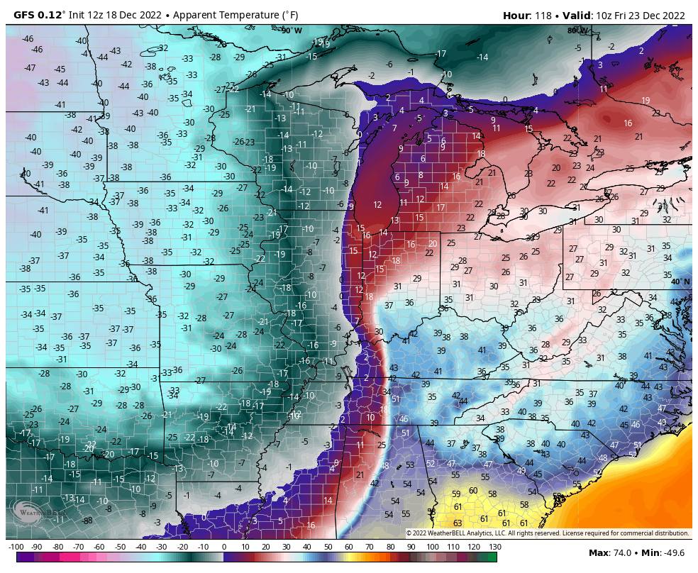
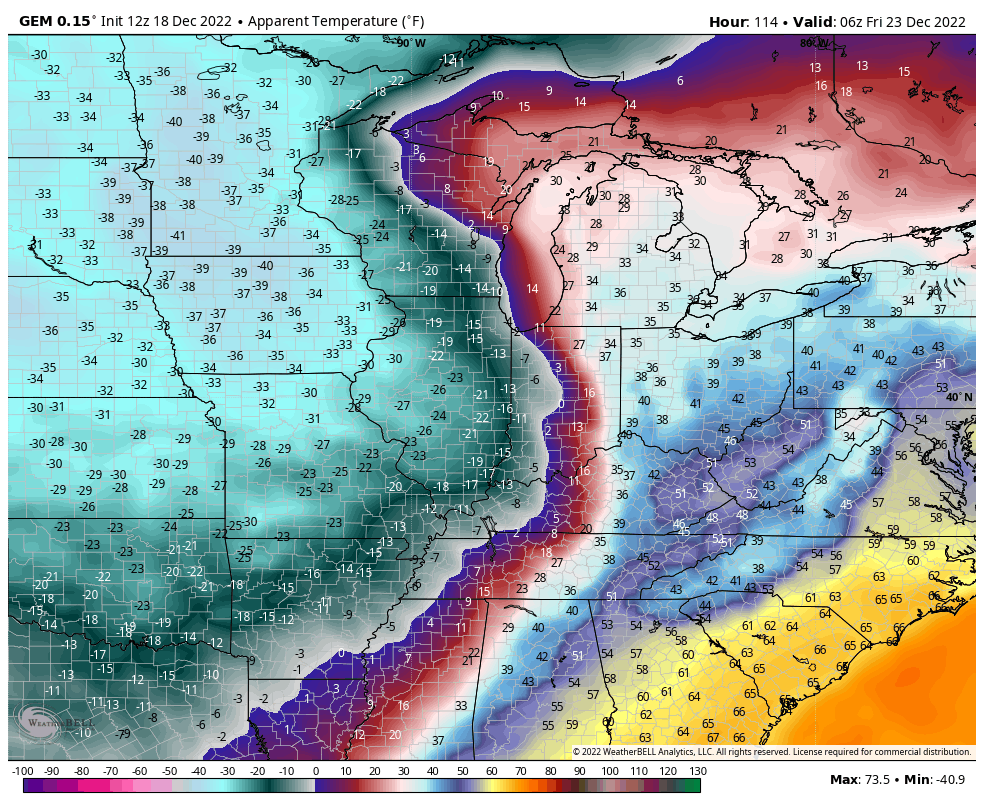
On to the models!
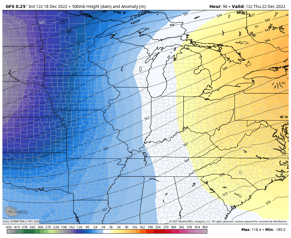
The GFS made a bit of a jump this morning as the latest run takes the upper level low just a bit north and west of prior runs…
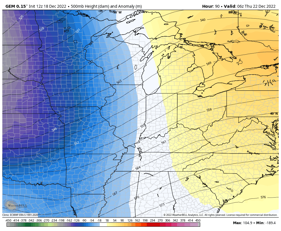
The Canadian Model is weaker with the energy, but has a similar look…
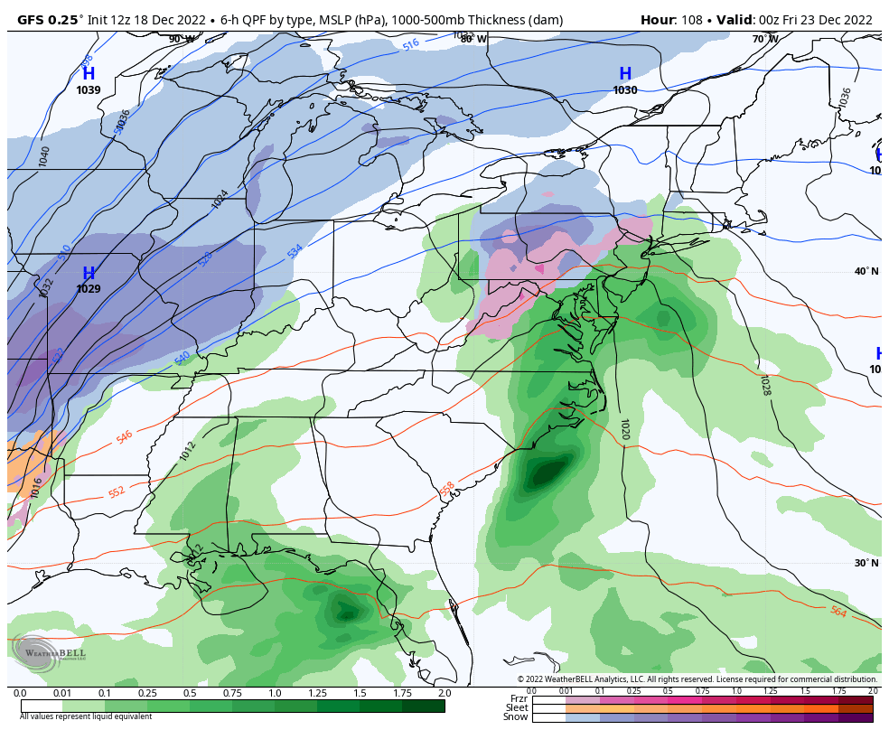
The GFS REALLY cranks this storm up now. Watch how the rain to wind driven snow scenario plays out…
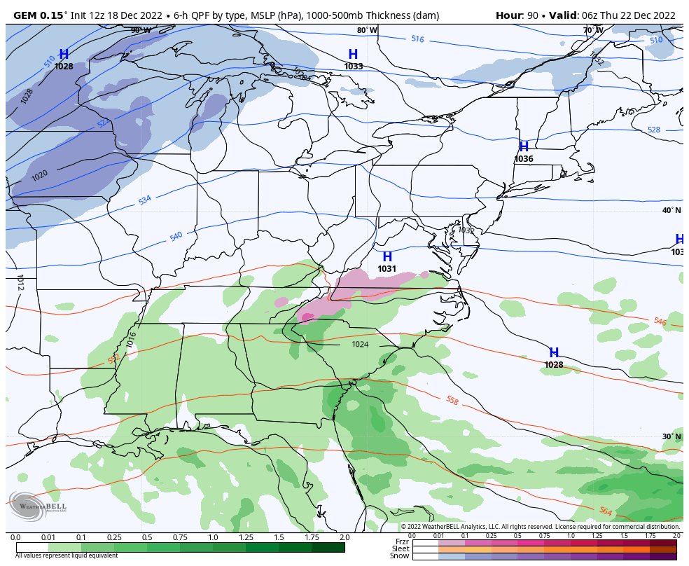
The Candian is weaker with the low, but has a similar end result…
Winds are a big player. Look at the gusts across the Ohio Valey…
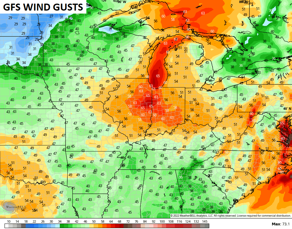
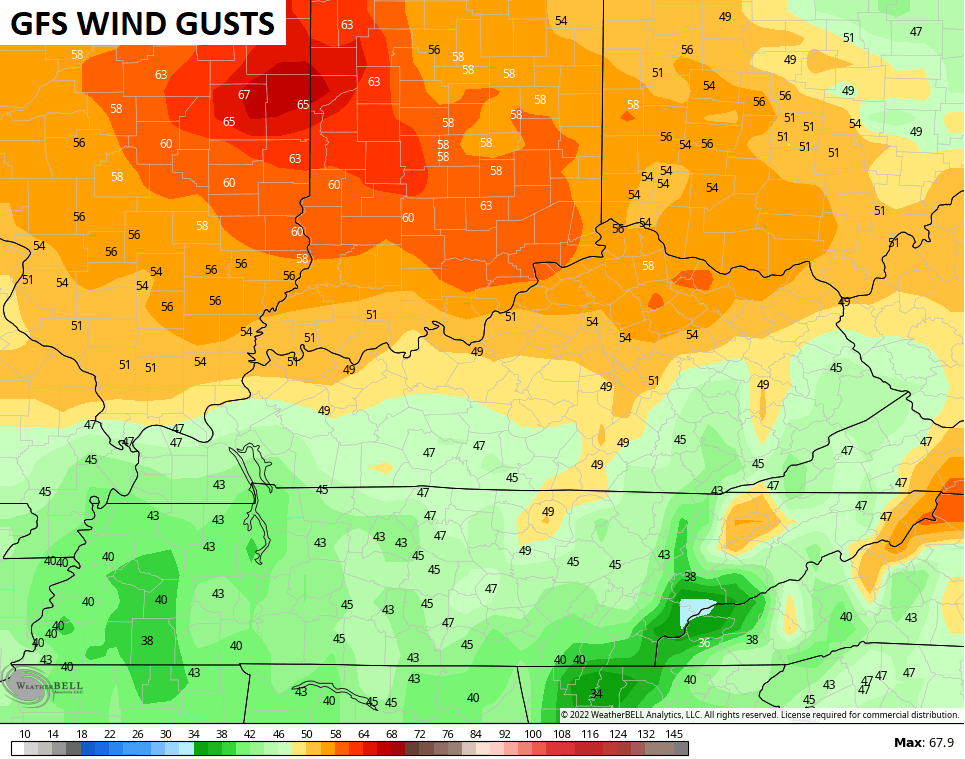
Whoa!
The cold crashing in behind this can take our lows below zero for Christmas weekend…
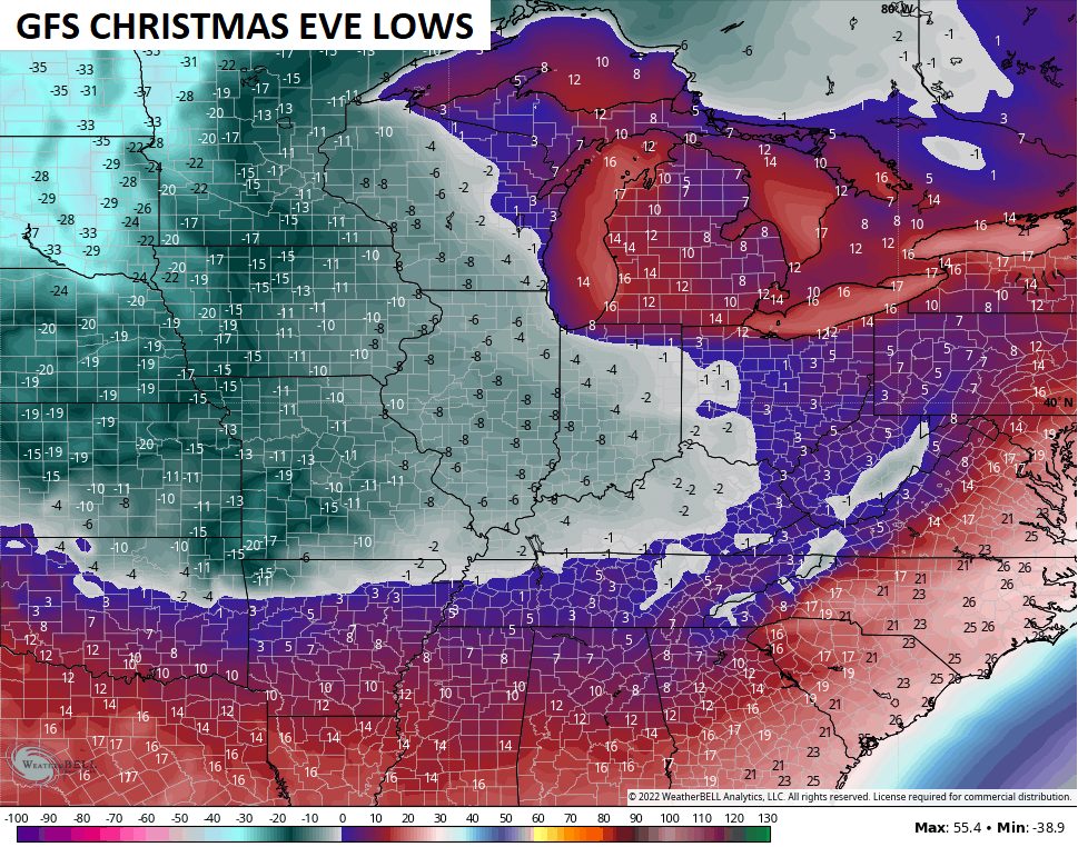
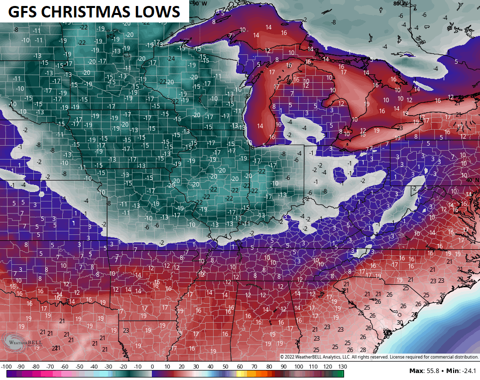
The deeper the snowpack, the colder those numbers can get.
Life-threatening wind chills are likely…
GFS
CANADIAN
That’s all you crazy kids get for now… And that’s a lot.
I’ll be back with updates later today. Have a great Sunday and take care.

afternoon song is whiskey bent and hell bound
Love that song
With the trend for the low pressure to be further north and west, it’s looking much more promising for the Chicago area to get a significant snowfall out of this. The GFS forecast model is predicting 60+ MPH wind gusts on Friday for the Chicago area… my goodness, combined with the snow, that would be one historic storm!
The sun is finally out today after days and days of clouds. But it is very cold and windy, with temps around 20 degrees. It’s going to be a cold one for the Eagles/Bears game.
Seems it would be more east and a tad south and then shoot north and north east. That said, a trend is a trend. Not a fan of shoveling my driveway anyways
The Euro is up to bat now.
Lets see what it has to offer.
NO PINK! NO PINK! NO,NO, PINK!!
Looks like another bump back west..
COME TO WKY
As of now you look to be in the premier area in the state.
GEFS Ensemble Snow Acc, still have alot of members east
This may be a stupid question but why does the low seem to never favor the east in Kentucky as far as snowfall tracks??. It seems to always take that turn I was just curious to hear why??? Well easy come easy go. I guess the Dome may be back lol
what? I think eastern KY always gets the most snow compared to the rest of the state…..what I wanna know is why with this bitter cold air is it trending west? I thought bitter cold air suppressed storms to the south not send them toward the bitter cold air
Marklex that’s a good question.
Crystal, if I remember right the last couple winters only the eastern part ky was getting the snow. I live here in far western ky by the Ohio river we have miss much of action the last couple winters .
I didn’t realize maybe your guys will get it then you are long overdue.
Hope so, we did get about 3-4 inches back in November which is very rare
Well I hope you get some.
I hope you get snow too.
Zero to five above and less than an inch of snow east of I-75. Lovely. Don’t get the kids’ hopes up for sledding if you live east of there. Starting to remind me of 2004. At least now they’re not predicting crazy amounts east of the interstate like they did then. Seems like the cold air never advanced past I-65.
Is it April yet?