Good evening, folks. It’s full steam ahead toward our harsh period of winter weather. This includes snow, high winds and life-threatening wind chills, and it’s all just in time for that busy travel period that is Christmas Weekend.
First things first… My breakdown from earlier remains unchanged…
THURSDAY
- Rain develops across much of the region, but it may start as a bit of a mix.
- Winds kick in from the southwest as temps spike ahead of the arctic front.
THURSDAY NIGHT
- The arctic front races eastward as low pressure develops along it. I’m still not sure exactly where this low develops and moves, but that’s critical to the forecast.
- Temps drop 30-40 degrees in an hour or two. Given everything will be wet before this happens, a massive flash freeze will take place. Everything ices up, folks.
- Rain rapidly changes to snow behind the front. A period of moderate to heavy snow is likely. How long of a period is the question.
- Winds gust to 40mph-50mph will be likely.
- Temps go below zero by Friday morning.
- Wind chills may reach -25
FRIDAY
- The period of snow behind the front moves away during the morning.
- Wraparound snow should then kick in during the afternoon and evening as the storm cranks to our north.
- Travel conditions will be ugly during this time.
- Winds will continue to gust to 40mph-50mph at times. Blowing snow may be an issue.
- Temps stay in the teens and may even drop into the single digits at some point.
- Wind chills may drop as low as -20.
FRIDAY NIGHT
- The wraparound snows will pull away, but travel continues to look rather ugly.
- Temps make a run at 0 or below.
- Wind chills will continue to run in the -10 to -20 degree range.
CHRISTMAS EVE
- A few flurries or a snow shower will be around.
- Gusty winds slowly come down.
- Temps stay in the upper single digits to mid teens for highs.
- Wind chills hang in the -5 to -10 range.
CHRISTMAS DAY
- The sky looks mostly dry, but a few flurries may try to enter the picture
- Highs from the middle teens to low 20s.
- Wind chills from -5 to 5.
The trend on the models today is back toward a farther east solution with the low, proving why one should never make a forecast based solely on what the last model said.
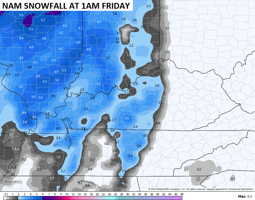
We are now getting into the range of the short range models such as the NAM. These models only go out 84 hours into the future, which is 1am Friday based on this afternoon’s run.
The NAM shows our front slamming through here with a rapid switch from rain to a little thumper…
Here’s the snow map that just barely gets into Friday…
The other short range model comes from the Canadian and it’s similar to the NAM…
Both models have a secondary low trying to develop along the front and that’s something to watch for.
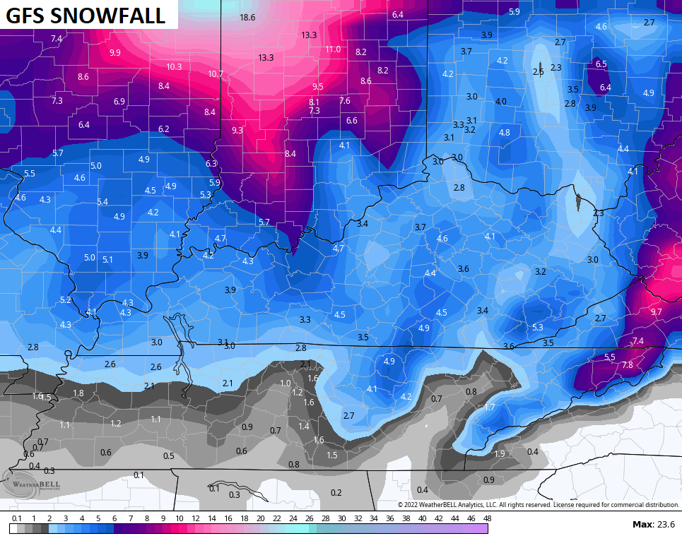
The GFS essentially held serve on what it’s showing…
You can see the snow right behind the front and then the wraparound snow Friday and Friday night. Here’s the snow map from that run of the GFS and this goes all the way through the event…
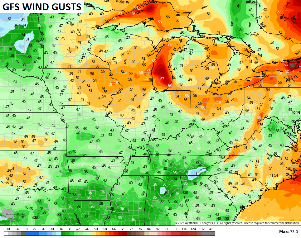
The wind gusts from this run of the GFS…
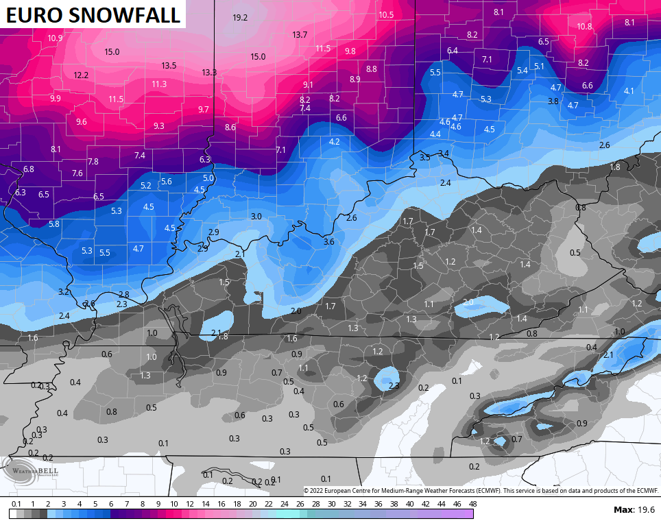
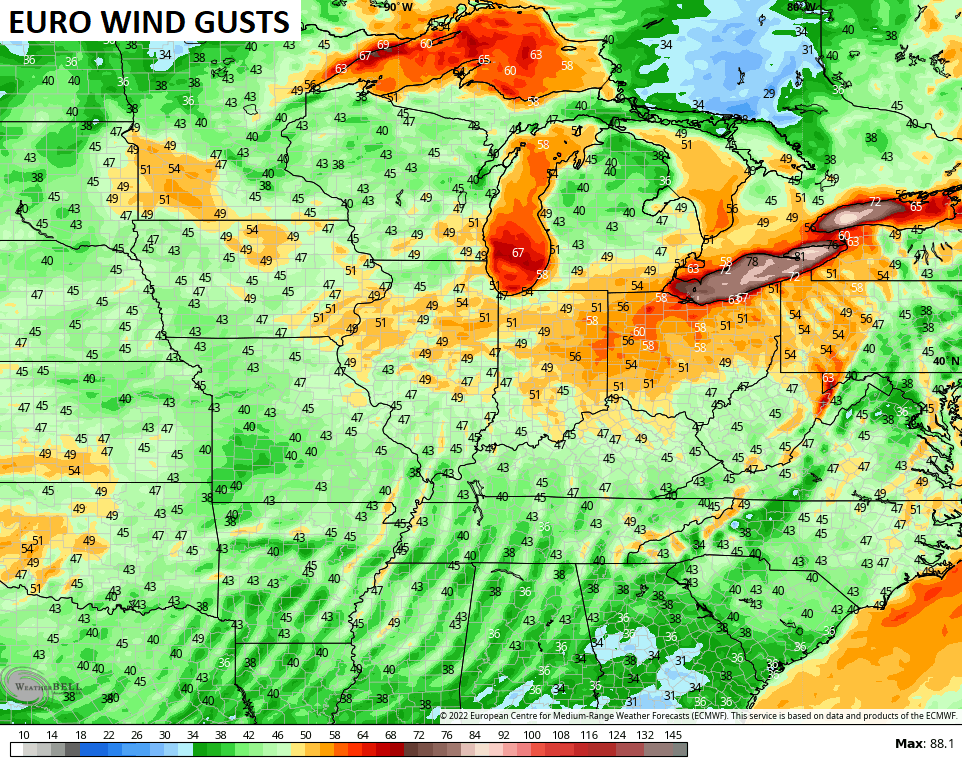
The EURO has a similar overall theme, but it’s the most progressive with this system. We’ve seen that a few times with the EURO this fall and early winter only to see it slow down and come in line with other models as we get closer…
Given the faster progression., the EURO snow map is a little more Grinchy…
Here are the wind gusts…
I will have the latest on WKYT NEWS at 10pm on the CW and at 11 on WKYT. I may even drop by for a quick late evening update.
Enjoy the rest of the day and take care.

Still a chance for me to win a fermented beverage bet! 3″ to 5″ was the bet- just need 3″. No western shift please 😉
BTW- Thanks CB!
I hope you win BubbaG. I also hope everyone that has missed out on the snow gets it. Hopefully we will all see a little snow. I do dread the cold.
I’ll buy ya a brew lol 😉
Winter Storm Watches have already been issued for a large part of Illinois due to the blizzard conditions expected Thursday night into Friday.
A flash freeze with 2+ inches of snow on top is still my biggest concern. Any preliminary snowmelt materials laid down prior to the system’s arrival will be washed away by the early rains, and salt applications will have minimum effect due to temperatures not getting out of the teens. Nor will it get much help from the Sun due to cloud cover, and because the Sun’s rays are at their weakest on the first day of Winter.
Happy Solstice to all!