Good Tuesday, everybody. Our weather is about to take a walk on the dangerous side as bitterly cold temps and wind chills move in for the end of the week and Christmas Weekend. Ushering in the cold will be some snow as a blizzard hits the Ohio Valley and Great Lakes.
Let me start things out with some fresh thoughts on the breakdown…
THURSDAY
- Rain develops across much of the region, but it may start as a bit of a mix.
- Winds kick in from the southwest as temps spike ahead of the arctic front.
- Most of us hit the middle and upper 40s.
THURSDAY NIGHT
- The arctic front races eastward as low pressure develops along it. I’m still not sure exactly where this low develops and moves, but that’s critical to the forecast.
- Temps drop 30-40 degrees in an hour or two. Given everything will be wet before this happens, a massive flash freeze will take place. Everything ices up fast, folks.
- Rain rapidly changes to snow behind the front. A period of moderate to heavy snow is likely, but this only lasts for a few hours as it moves through. Travel conditions will become treacherous very quickly with this band of snow.
- Winds gust to 40mph will be likely.
- Temps go below zero by Friday morning for central and western Kentucky. Single digits show up in the east.
- Wind chills may reach -25 and could push -30 in the north.
FRIDAY
- The period of snow behind the front moves away during the morning.
- After a break with flakes, wraparound snow globe light snows should then kick in during the afternoon and evening as the storm cranks to our north.
- Travel conditions will be ugly during this time.
- Winds will continue to gust to 40mph-50mph at times. Blowing snow may be an issue.
- Temps likely stay in the single digits for most of the state.
- Wind chills may drop as low as -25.
FRIDAY NIGHT
- The wraparound snows will pull away, but travel continues to look rather ugly.
- Temps make a run at 0 or below.
- Wind chills will continue to run in the -10 to -20 degree range.
CHRISTMAS EVE
- A few flurries or a snow shower will be around.
- Gusty winds slowly come down.
- Temps stay in the upper single digits to mid teens for highs.
- Wind chills hang in the -5 to -15 range.
CHRISTMAS DAY
- A couple of flurries will be possible.
- Highs from the middle teens to low 20s.
- Wind chills from -10 to 5.
I’m still not ready to make a First Call map because I’m not convinced, this system doesn’t trend east a little more. That’s something we are seeing on the models and I suspect better sampling of the atmosphere is why. The energy with this storm is now coming ashore on the west coast and that means better data is being ingested by the models.
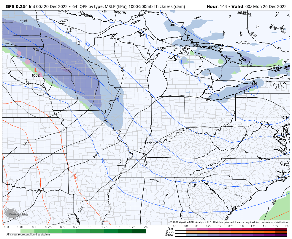
The GFS is close to bringing that low across western Kentucky and into Indiana and Ohio…
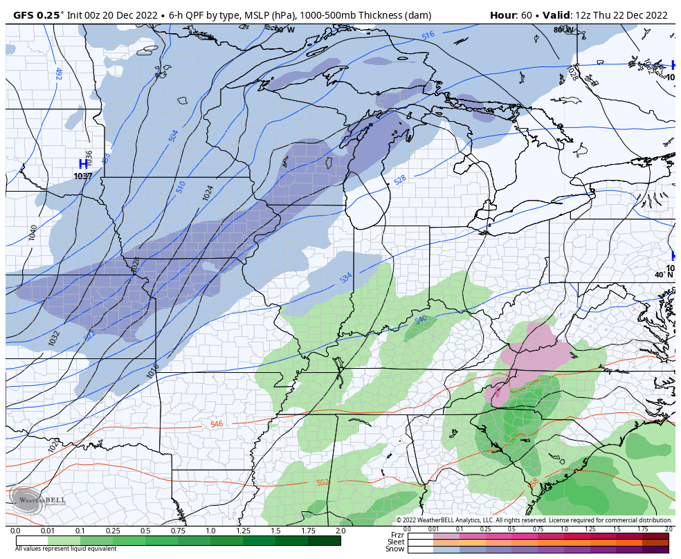
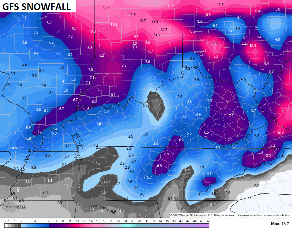
That brings some healthy wraparound snows in the bitter cold on Friday. Given those high ratios, the model spits out some hefty numbers…
That took a turn, didn’t it? I’m certainly not ready to buy it, but it’s a thought.
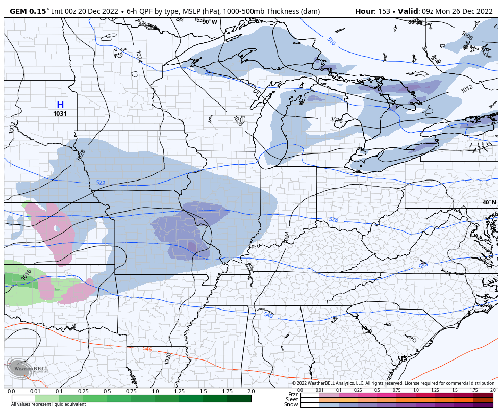
The Canadian Model is also east of what it had been showing…
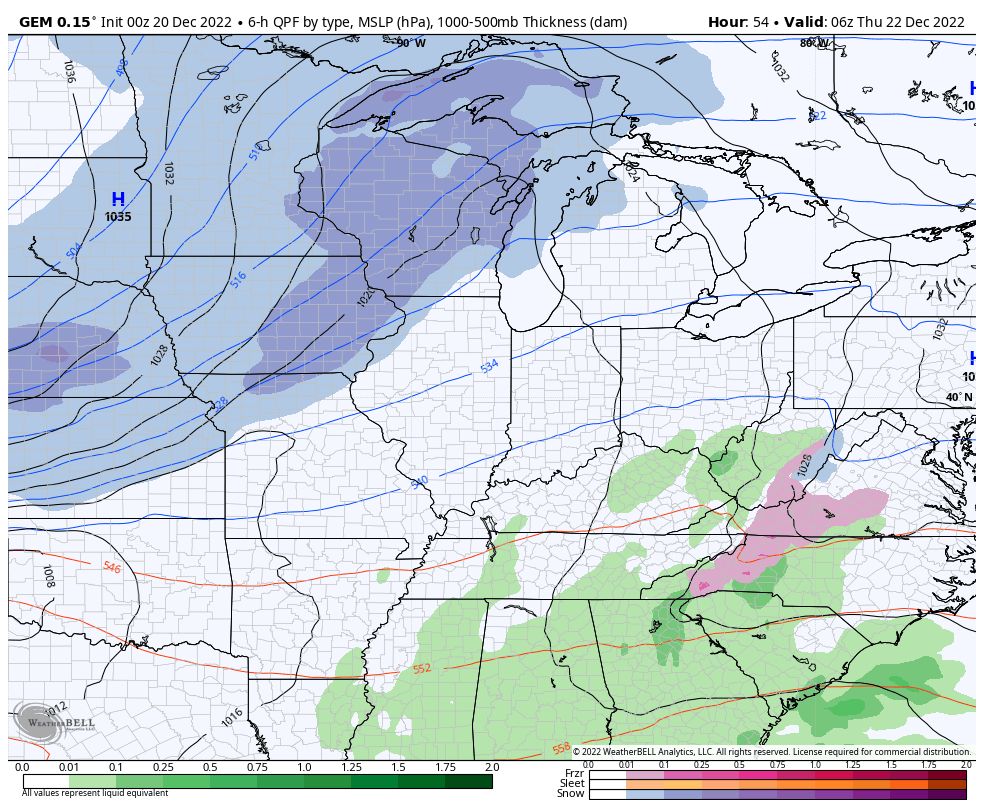
That run takes the heavy snow band much farther south and very close to the Ohio River…
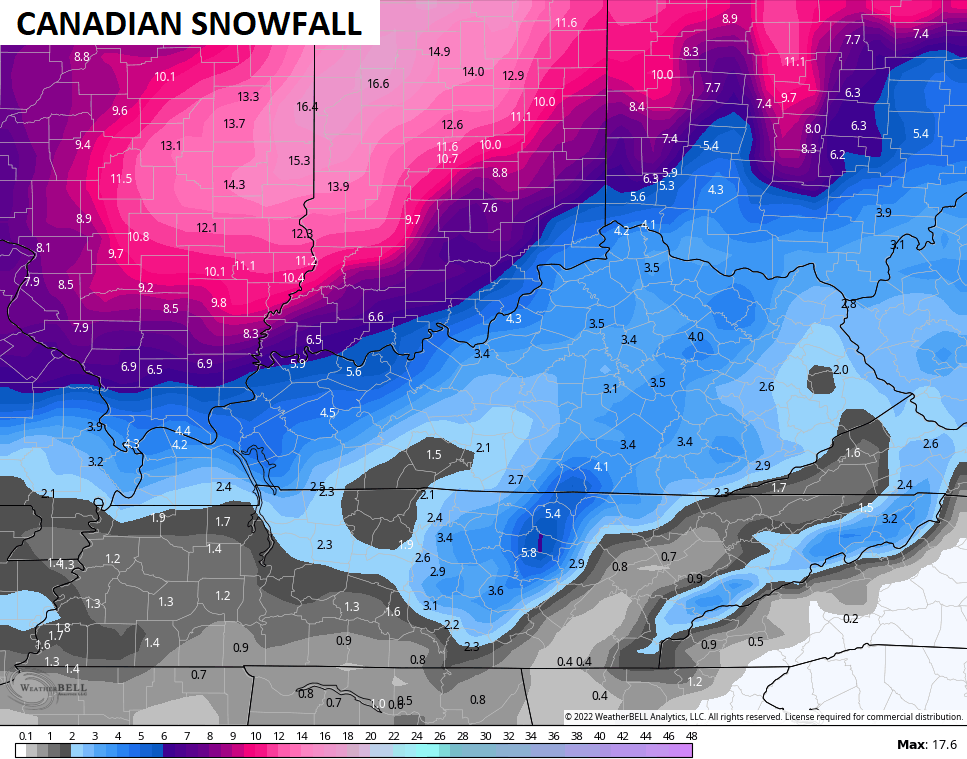
In addition to that main snow line sinking southward, you can clearly see the wraparound snows doing some work for the rest of the state on Friday.
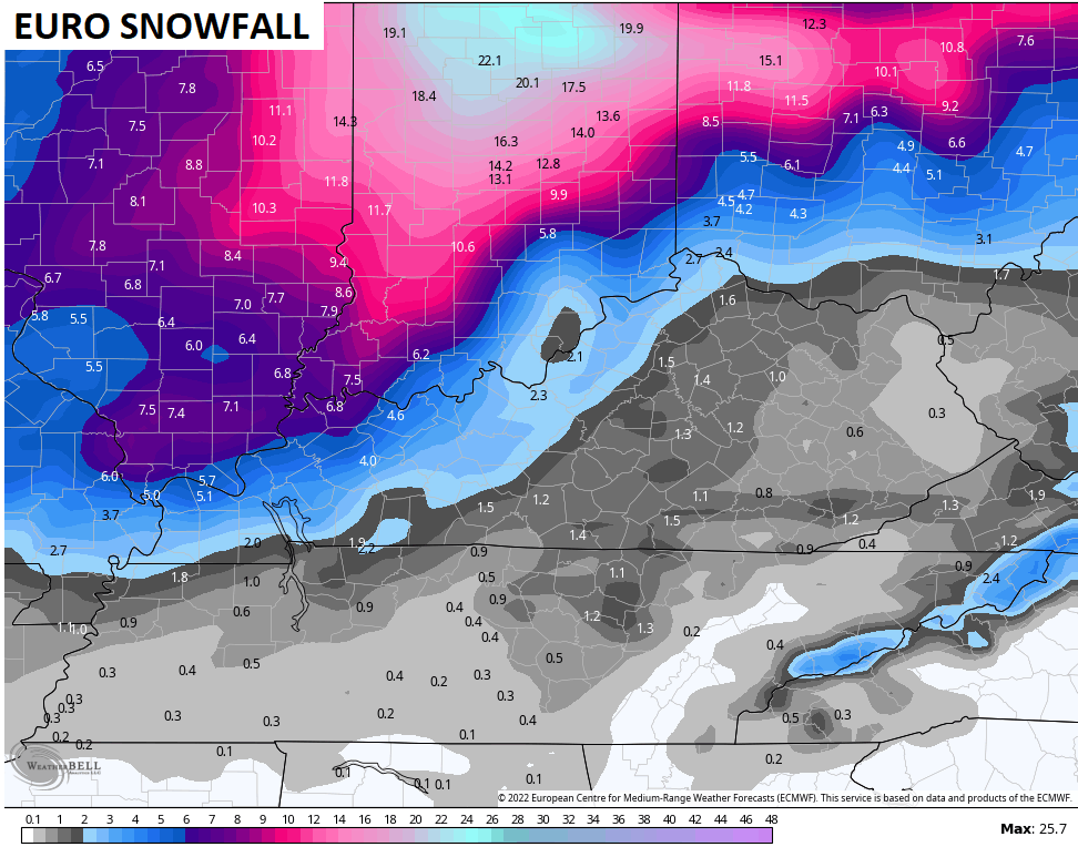
The EURO also continued the eastward trend with the model, but is still not handling the wraparound snow very well. The EURO now takes the low across western Kentucky to near Louisville then north of Dayton, Ohio…

The snowfall map from the EURO is too light when compared to other models, but look at the heavy snow band sinking to the Ohio River…
I also look at the ICON Model sometimes just to get a general view of trends developing. This model made a huge jump east and takes the low right over central Kentucky into Ohio…
![]()
![]()
The trend is your snowy friend, and I will watch the runs from this morning and put out a First Call For Snowfall map by this afternoon.
Guess what may follow this up? Another snow threat for Monday and Tuesday of next week. The models have been growing stronger with this signal for a bit and, with arctic air still in place, any snow maker would do well.
Here’s the GFS with it…
And the Canadian trying to round the bend…
That could be followed by another shot of bitter cold lows by the middle of next week.
I’ll see you guys back here for updates later today. Have a terrific Tuesday and take care.

lose yourself m n m
Every snowfall map is showing an area with a doughnut hole.
It’s the rarely seen Krispy Kreme effect, caused by pockets of dry air rapidly Dunkin to earth.
Rain train please don’t leave the station
I remember back in that blizzard of 78 they were calling for snow flurries and the barometer of that storm still stands as a record today. I read yesterday this storm may have some similar barometer just not as strong that was. Be on guard regardless.
I was on the east coast at the time, and remember that storm vividly. It may have been what is referred to today as a “bomb” storm, a.k.a. explosive cyclogenesis, where a storm system’s central pressure drops at least 24 millibars within 24 hours. More and more this system is turning into a dud for our region
JoeD, i live far western ky by the Ohio river in Union.co as of now we maybe in the sweet spot if the models are right. Hopefully it will go farther east maybe your area in Bowling Green will get some snow.
Looks like snow is dwindling even up north..System is really falling apart..Now if temps would only moderate..