Good afternoon, everyone. We continue to see the setup evolving toward a wild ride of winter weather coming from Thursday through Christmas Weekend. Snow, blowing snow, bitter cold temps and life-threatening wind chills are on the way to Kentucky and surrounding states.
I was close to pulling the trigger on a Threat, but decided against it as I’m still not confident enough on where the heaviest snow band sets up with the track of the low.
Let’s start with the latest model trends… They continue to drift east.
This whole setup essentially boils down to where the arctic front is when low pressure develops along it. The trend since yesterday has been for this front to make it farther east before that low develops.
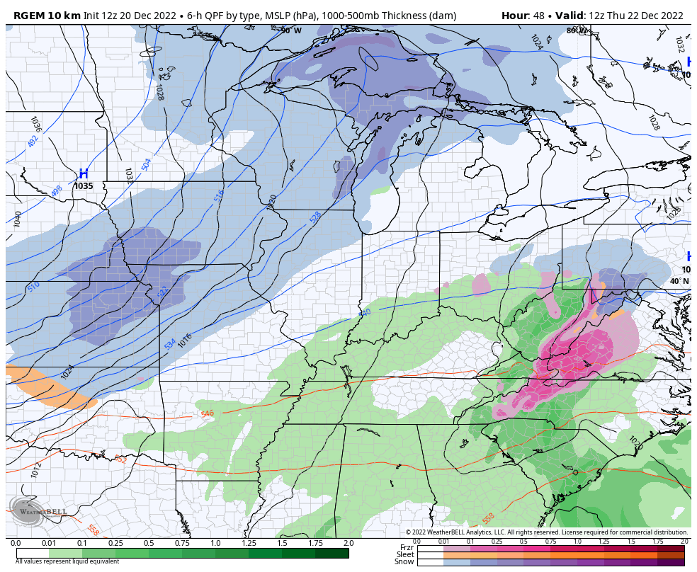
The new NAM now takes the low across central Kentucky into Ohio…
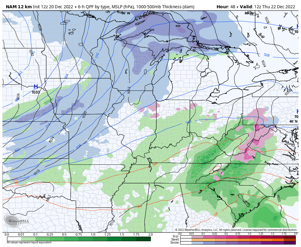
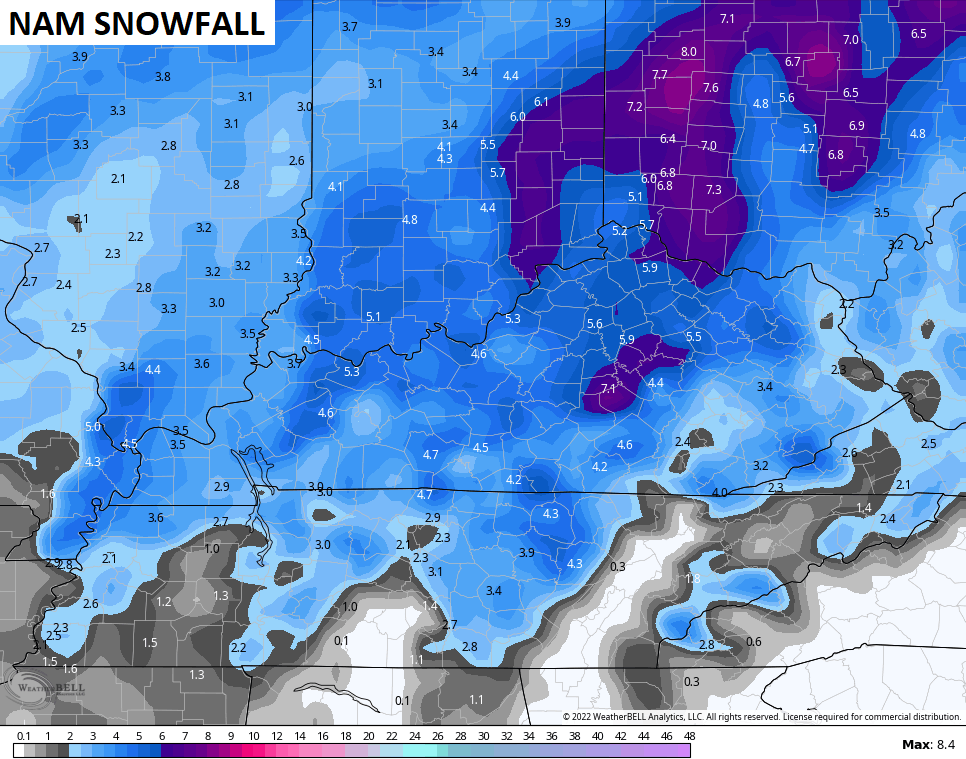
That’s obviously a better snow track around here as you get a longer duration snowfall behind the front and along the low. This run of the NAM went all in on snow around here…
I’m not ready to bite on those amounts, but I can say that’s a totally plausible scenario if the low passes that far east.
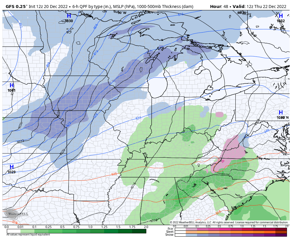
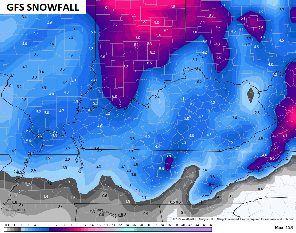
The GFS is little weaker with the low, but has similar thoughts on snow…
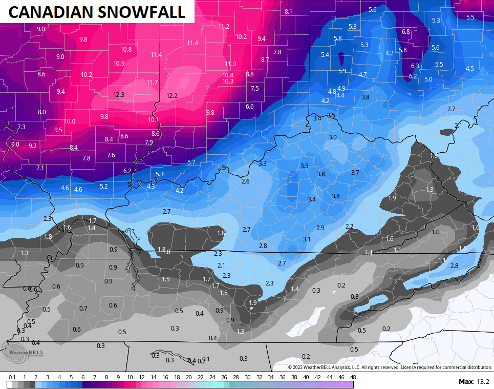
The Canadian is in the same camp with the setup, but isn’t as enthusiastic on the snow as the American Models…

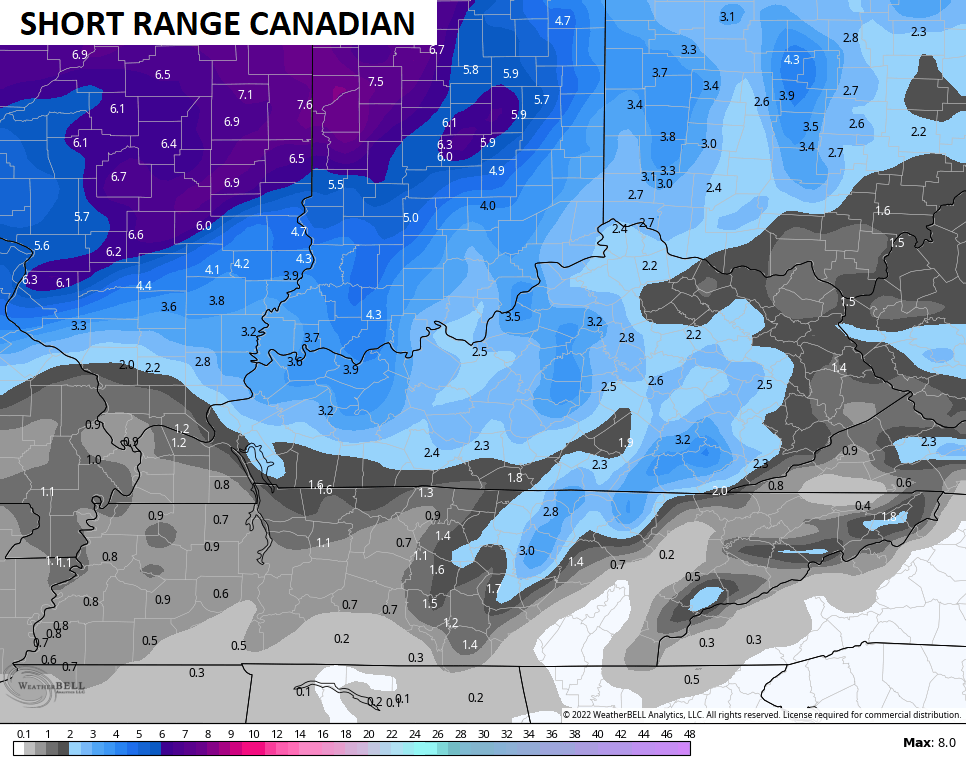
The Short Range Canadian isn’t quite as amped up with the snow, but continues that eastward drift…
Here’s the snow map from that run…
The ICON is similar to the NAM with the track of the low right on top of central Kentucky…
![]()
![]()
I should be able to get a First Call For Snowfall map out for you later today on WKYT-TV then here on KWC.
I’ll leave the breakdown as is for now…
THURSDAY
- Rain develops across much of the region, but it may start as a bit of a mix.
- Winds kick in from the southwest as temps spike ahead of the arctic front.
- Most of us hit the middle and upper 40s.
THURSDAY NIGHT
- The arctic front races eastward as low pressure develops along it. I’m still not sure exactly where this low develops and moves, but that’s critical to the forecast.
- Temps drop 30-40 degrees in an hour or two. Given everything will be wet before this happens, a massive flash freeze will take place. Everything ices up fast, folks.
- Rain rapidly changes to snow behind the front. A period of moderate to heavy snow is likely, but this only lasts for a few hours as it moves through. Travel conditions will become treacherous very quickly with this band of snow.
- Winds gust to 40mph will be likely.
- Temps go below zero by Friday morning for central and western Kentucky. Single digits show up in the east.
- Wind chills may reach -25 and could push -30 in the north.
FRIDAY
- The period of snow behind the front moves away during the morning.
- After a break with flakes, wraparound snow globe light snows should then kick in during the afternoon and evening as the storm cranks to our north.
- Travel conditions will be ugly during this time.
- Winds will continue to gust to 40mph-50mph at times. Blowing snow may be an issue.
- Temps likely stay in the single digits for most of the state.
- Wind chills may drop as low as -25.
FRIDAY NIGHT
- The wraparound snows will pull away, but travel continues to look rather ugly.
- Temps make a run at 0 or below.
- Wind chills will continue to run in the -10 to -20 degree range.
CHRISTMAS EVE
- A few flurries or a snow shower will be around.
- Gusty winds slowly come down.
- Temps stay in the upper single digits to mid teens for highs.
- Wind chills hang in the -5 to -15 range.
CHRISTMAS DAY
- A couple of flurries will be possible.
- Highs from the middle teens to low 20s.
- Wind chills from -10 to 5.
I’ll be back with updates later today. Have a good one and take care.

the NAM IS THE 48 HOUR MODEL, I LIVE BY THE NAME. WILDSIDE MARKY MARK IS THE SONG.
MAYBE 1-3 INCHES I SAY .
Sticking with 3″ to 5″, since still seems odd the event is not flowing more easterly.
Something grossly unfair about having to endure near-record cold without hardly any snow 🙂