Good Thursday, everyone. A winter storm is taking aim at Kentucky today and it’s bringing some absolutely wicked weather. We have snow, blowing snow, bitterly cold temps and life-threatening wind chills that will take us through Christmas weekend.
We are in full blown Winter Storm ALERT for the increasing threat for a few to several inches of snow behind an arctic front arriving later today. Then we track rounds of light snow and even some snow squalls into Christmas weekend.
Here’s my latest Call For Snowfall…
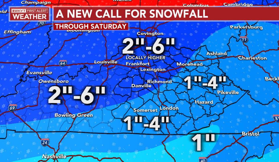
I will have another update or two coming before the Last Call For Snowfall this afternoon.
Some of the models are really amped up on the snow behind this system and the wraparound stuff into the weekend. The GFS has been consistently showing the highest totals and it continues to do so…
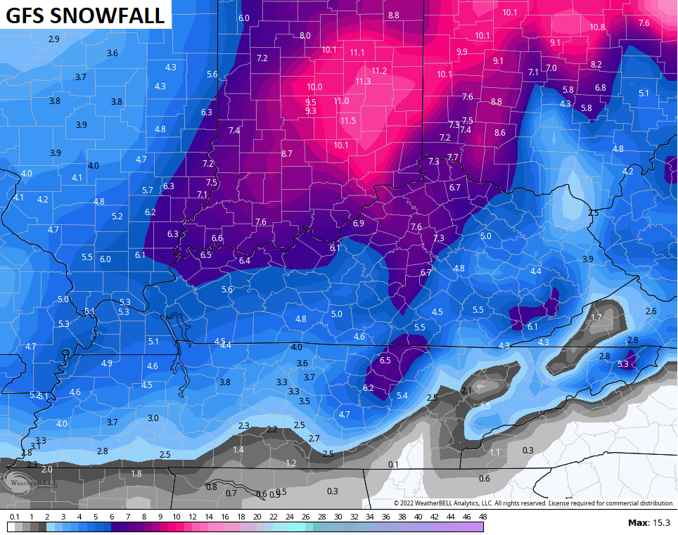
That’s probably overdone, but we will soon find out for sure.
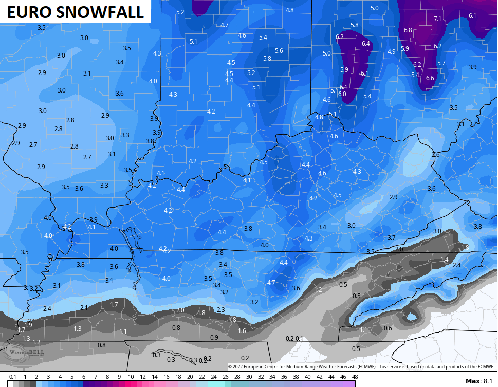
The EURO had been the snow grinch with the lowest total of any model, but it joined the party Wednesday and has been trending toward the GFS totals. Here’s the latest run…
Folks, we are likely to have whiteout and near blizzard conditions at times behind the arctic front through tonight. Those light snows and snow squalls coming Friday into the weekend may also play the part from time to time.
For those wondering what conditions constitute a blizzard, here is the official criteria from the NWS: Sustained wind or frequent gusts to 35 mph or greater; and considerable falling and/or blowing snow reducing visibility frequently to less than 1/4 mile for 3 or more hours.
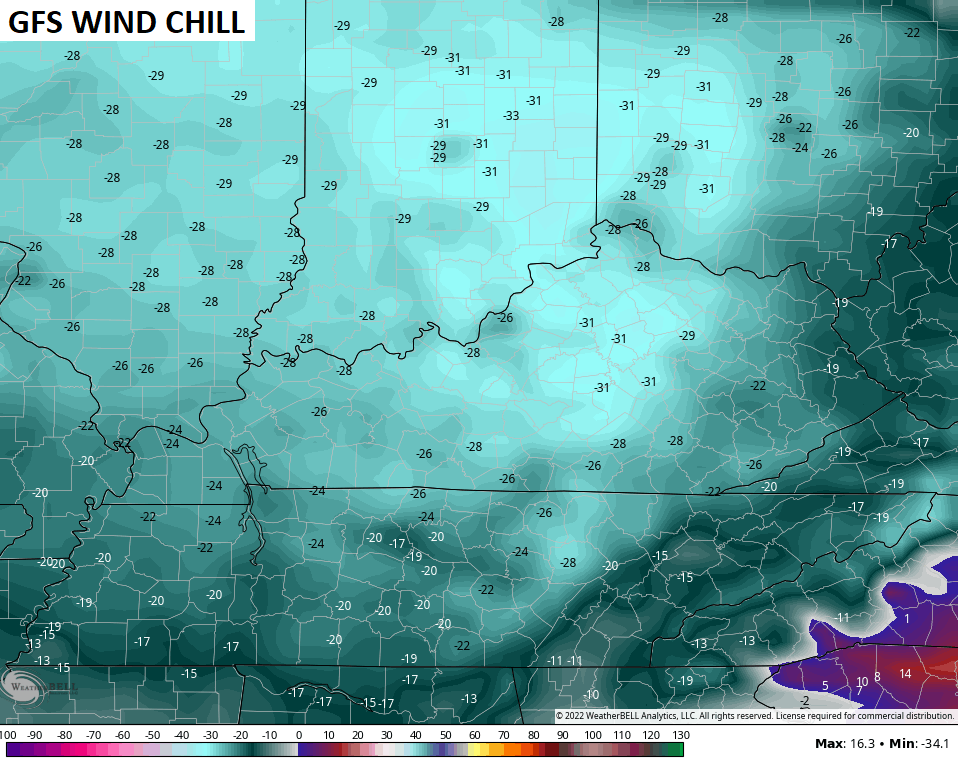
Temps are absurd behind this front. 0 to -10 are possible tonight and Friday morning…
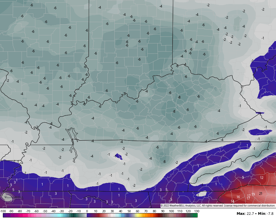
If you throw in winds gusting to 40mph or a little higher, you get the life-threatening wind chill numbers that last through Christmas weekend. The absolute lowest numbers are likely late tonight into Friday morning and may reach -30 or lower…
Let’s breakdown the timeframes with all this…
THIS AFTERNOON
- Showers develop through the day as temps spike deep into the 40s and may even hit 50 in a few spots.
- The arctic front races into western Kentucky late this afternoon. Rain will change to snow in the west and likely cause some issues by rush hour.
THIS EVENING
- The cold front sweeps into central Kentucky arriving along Interstate 65 between 7pm and 9pm. This should be near Interstate 75 around 10 or 11pm.
- Temps drop 30-40 degrees in an hour or two as the front passes. Given everything will be wet before this happens, a massive flash freeze will take place.
- Rain rapidly changes to snow behind the front. An increasing band of moderate to heavy snow is likely.
- Winds gust to 40mph will be likely creating whiteout/near blizzard conditions for a 3-5 hour period right behind the front.
- Travel conditions will be absolutely awful during and after this period of snow.
TONIGHT
- The band of heavy snow pushes across central Kentucky into the east. Whiteout conditions will tag along for the ride.
- Temps bottom out into the 0 to -10 range for much of the state by Friday morning.
- Wind chills reach -25 and could push -30 in some spots.
FRIDAY
- The period of snow behind the front moves away during the morning.
- After a break with flakes, wraparound snow globe light snows should then kick in during the afternoon and evening as the storm cranks to our north.
- A few snow showers and squalls may also develop.
- Travel conditions will continue to be ugly.
- Winds will continue to gust to 40mph-45mph at times. Blowing snow will be an issue.
- Temps stay in the single digits across the state.
- Wind chills hang in the -15 to -25 range.
FRIDAY NIGHT
- Additional light snows and snow showers will put down light accumulations.
- Temps make a run at 0 or below.
- Wind chills will continue to run in the -15 to -25 degree range.
CHRISTMAS EVE
- Snow showers and a squall or two will still be around and put down some additional light accumulations.
- Gusty winds slowly come down into the 30mph range.
- Temps stay in the upper single digits to low teens for highs.
- Wind chills hang in the -5 to -20 range.
CHRISTMAS DAY
- We could still be talking about light snow and flurries!
- Lows are around 0 once again.
- Highs are mainly in the teens.
- Wind chills from -15 to 5 above.
- IT’S A WHITE CHRISTMAS!!! ❄️🎅🎄🥶
I will have your normal updates coming later today, so check back. Until then, I leave you with your tracking tools for the day…

Have a great Thursday and take care.

BOOM,
Stock up on essential fluids! 😉
What’s today’s song Rolo ?
I Feel A Cold One Comin’ On by Montgomery Gentry
jeff already used that one a few days ago. todays is almost home by craig morgan whos coming to renfro in april.
Doesn’t matter. My song stands.
Thanks Chris, I’m ready for the Arctic Air. Been through it many times in my life. I just hope my aging electric and heat pumps hold out. Snows along with this coming blizzard have been increasing in my local forecast, so finally some agreement.
I will make sure I am in my home by 6 pm.
I live near I-65.
Good luck out there today everybody.
I would love to comeback and update my thoughts later today, but that will probably be
Impossible due to cyber traffic.
Not hearing anything about possible power outages..Think there would be tremendous strain on the grid with everyone trying to stay warm..Hope everyone is prepared..
Knowing my luck I will be the first to lose my power. ( Wind Gust)
People should not take these temps lightly. Prepare, have a secondary heat source in case of power outages, and dont take chances.
Only heat source if the power fails in my home is long johns and blizzard overalls. Got me through the long power outage in the 2009 Ice Storm. We’ll find out if this is enough protection this time around ?
weather related i say go away system, bailey do the bailey strut for go away.
bad karma to talk bout power outages. CMON MAN!!!!!!!!!!
I finally “get it”, duh! the reason for the lower snow numbers is the speed the system is pushing through with the main snow. Freight train!
Current temperature in St. Louis is 41°F, current temperature in Kansas City is 1°F.
If we do get outages, they’re likely to be caused by people who had no business driving, running into power poles.
Here’s the solution for the power companies BURY THE LINES. I pitch this to my power company in 2009 and their response was too costly. Money before lives.
NWS says 1/2 an inch, GFS says 4″ & basically every other model is trending towards GFS – we shall see 🙂
I hope none of us loose power! Time to break out the flannel sheets and flannel pajamas. Don’t forget the pets outside.