Good afternoon, everyone. A major winter storm/blizzard is working into the Ohio Valley today and is bringing some of the worst winter weather you are ever going to find here in Kentucky. Several inches of wind whipped snow will be accompanied by life-threatening cold and wind chills.
The system seems fairly well-behaved at this point. I will be putting out a Last Call For Snowfall later today, but what I already have out seems to be in pretty good shape right now…
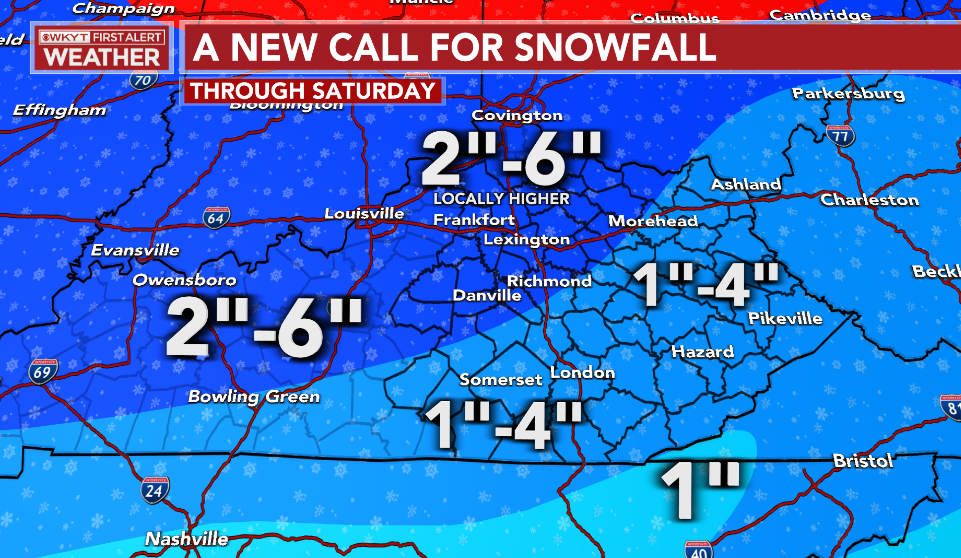
On the low end of that forecast is an inch or two of snow. The high end of the forecast is 4-6 inches, and that’s through Saturday. Some only hit the bottom while others push the top end with many right in the middle of it all.
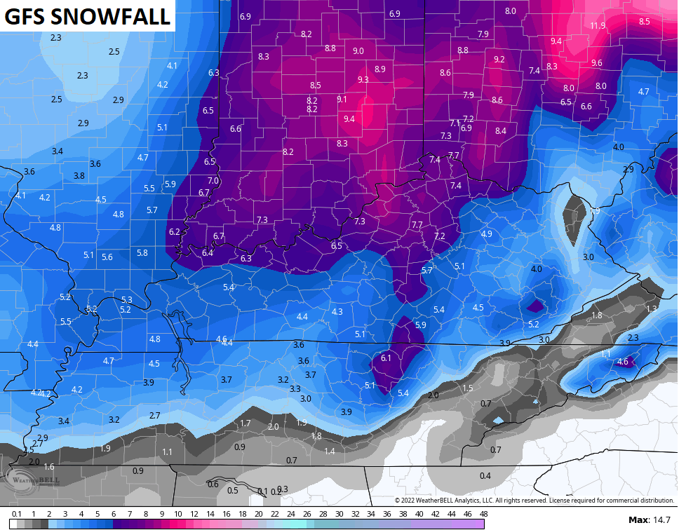
The GFS continues to be the most aggressive with the snow and the snow showers/squalls into the weekend…
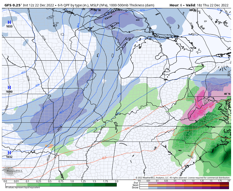
The snowfall from this model is way up there still…
Can we get some thundersnow from action right behind the arctic front? The HRRR suggests that’s a possibility with the flash rate forecast…

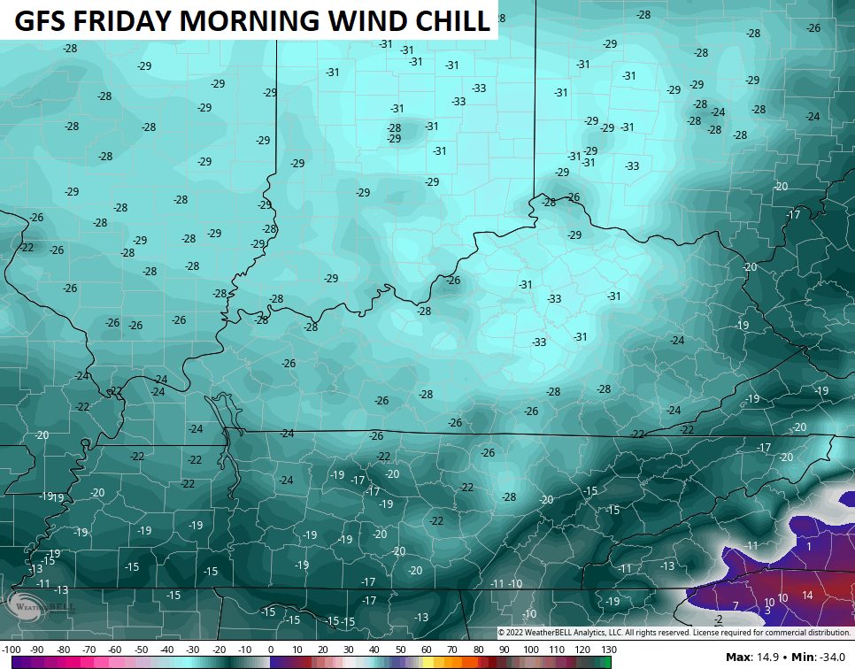
The bitter cold is absurd with lows going well below zero tonight…

Oh, and those wind chills…
Let’s freshen up the breakdown of this prolonged period of harsh winter weather…
THIS EVENING
- The cold front sweeps into central Kentucky arriving along Interstate 65 between 7pm and 9pm. This should be near Interstate 75 around 10 or 11pm.
- Temps drop 30-40 degrees in an hour or two as the front passes. Given everything will be wet before this happens, a massive flash freeze will take place.
- Rain rapidly changes to snow behind the front. An increasing band of moderate to heavy snow is likely.
- Winds gust to 40mph will be likely creating whiteout/near blizzard conditions for a 3-5 hour period right behind the front.
- Travel conditions will be absolutely awful during and after this period of snow.
TONIGHT
- The band of heavy snow pushes across central Kentucky into the east. Whiteout conditions will tag along for the ride.
- Temps bottom out into the 0 to -10 range for much of the state by Friday morning.
- Wind chills reach -25 and could push -30 in some spots.
FRIDAY
- The period of snow behind the front moves away during the morning.
- After a break with flakes, wraparound snow globe light snows should then kick in during the afternoon and evening as the storm cranks to our north.
- A few snow showers and squalls may also develop.
- Travel conditions will continue to be ugly.
- Winds will continue to gust to 40mph-45mph at times. Blowing snow will be an issue.
- Temps stay in the single digits across the state.
- Wind chills hang in the -15 to -25 range.
FRIDAY NIGHT
- Additional light snows and snow showers will put down light accumulations.
- Temps make a run at 0 or below.
- Wind chills will continue to run in the -15 to -25 degree range.
CHRISTMAS EVE
- Snow showers and a squall or two will still be around and put down some additional light accumulations.
- Gusty winds slowly come down into the 30mph range.
- Temps stay in the upper single digits to low teens for highs.
- Wind chills hang in the -5 to -20 range.
CHRISTMAS DAY
- We could still be talking about light snow and flurries!
- Lows are around 0 once again.
- Highs are mainly in the teens.
- Wind chills from -15 to 5 above.
- IT’S A WHITE CHRISTMAS!!! ❄️🎅🎄🥶
I will be on WKYT-TV starting at 4pm and will have the latest on this storm as it moves in and, of course, the Last Call For Snowfall. I’ll also drop by later this evening with that final call and all the tracking tools you can handle.
Speaking of tracking tools, let’s get this winter storm tracking party started…

PADUCAH


FORT CAMPBELL

BOWLING GREEN


E-TOWN


LOUISVILLE


FRANKFORT


COVINGTON AREA


I’ll add more cams for the rest of the region on my next update. Make it a great day and take care.

Appears Western Ky got upgraded to a Winter Storm Warning. Thanks for the updates.
mark chesnutt to cold at home.
The NWS just can’t make up there mind at first we had winter weather watch and then drop it to advisory. They have up grade it to winter storm warning here bout an hour ago.
FINALLY, LMK moved to a warning.
Reminds me of the movie ” The Day after Tomorrow. ” We’ll make that today’s movie.
Everyone stay warm and safe for Christmas.
I’m hoping no one loses power and all stay safe & warm.