Good afternoon, everyone. Light snow and snow showers continue to push across central and eastern Kentucky as we look toward our winter storm system. This rolls in here Tuesday night and early Wednesday with snow and rain.
Light accumulations are showing up across the east and southeast and will continue through the afternoon. Once the sun goes down, watch for slick spots to develop as temps drop into the 20s.
Here are your radars for the afternoon…

Our developing winter storm is still on track to impact our region Tuesday night through Thursday. In the overall scheme of things, I have no changes to my thoughts on this system.
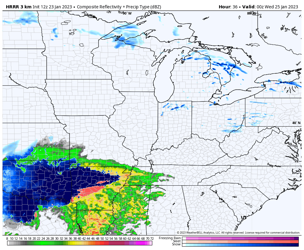
If you’re a snow lover, you’re cheering on the HRRR because it has a farther south tracking low and a much more widespread snow across Kentucky. This animation goes from 7pm Tuesday through 7am Wednesday…
The Future Radar from the Hi Res NAM goes from 7pm Tuesday through 7pm Wednesday. This doesn’t show the widespread snow like the HRRR, but shows the front end thumper snow before rain…
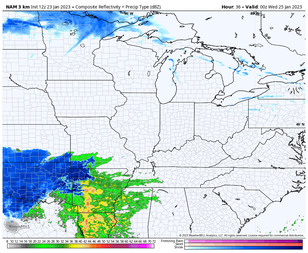
You can see the wraparound snows starting to dive in behind the departing low.
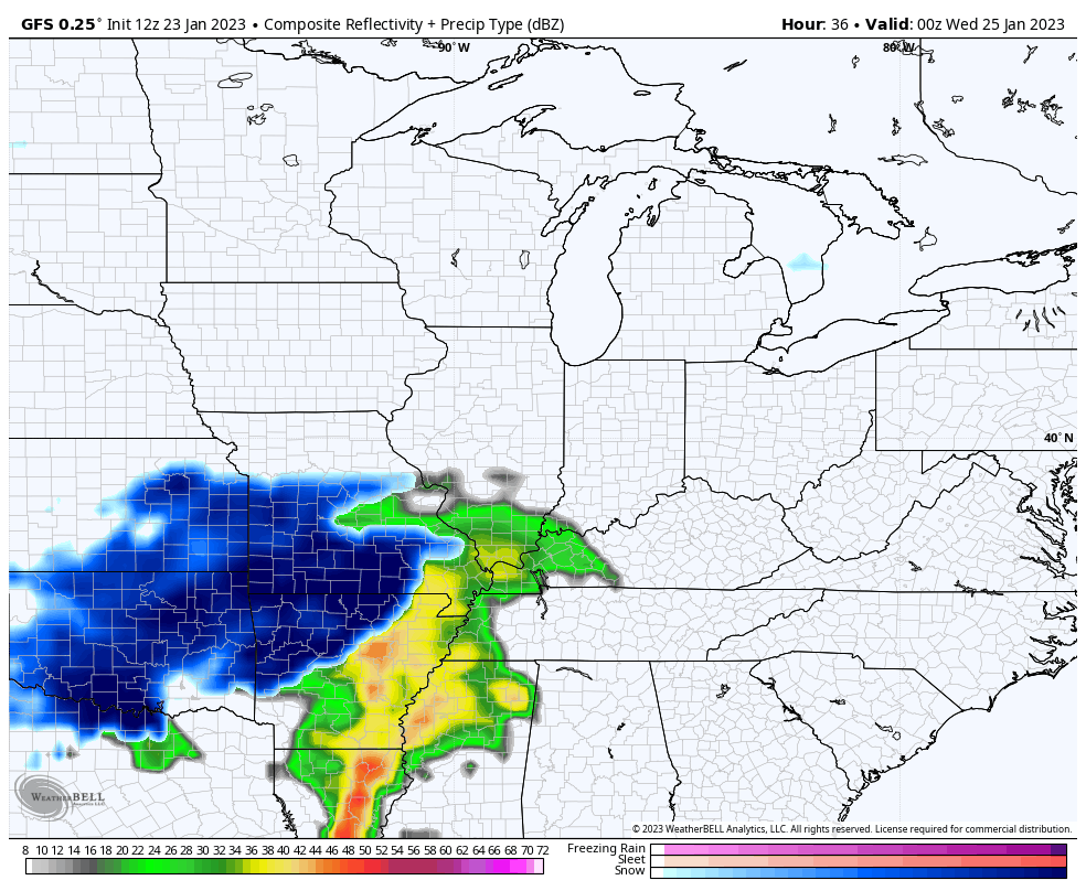
The Future Radar from the GFS gives us a look in 3 hour increments and does not have the resolution of the above models. Still, you can see the front end snow to rain followed by the wraparound snows…
Here’s the breakdown of how things may play out:
- This is a far-reaching storm that will impact areas from Texas to New England.
- Rain and snow move into Kentucky Tuesday night.
- A heavy band of snow will likely impact areas of the north and west. This takes us into Wednesday morning.
- This band of snow can be a thumper of a wet snowfall for a few hours.
- Areas across the south and southeast are mainly rain.
- The actual low pressure looks to move across Kentucky on Wednesday, with a switch to rain for a few hours.
- As the low goes by, cold air quickly rushes back in with wraparound light snows developing Wednesday evening.
- A healthy wraparound light snow event then looks likely for most of the state Wednesday night and Thursday.
- Snow showers would linger into Friday.
- Snowfall from Wednesday night through Friday could be on the tune of 1″-3″ for many.
- I expect some snow days later this week.
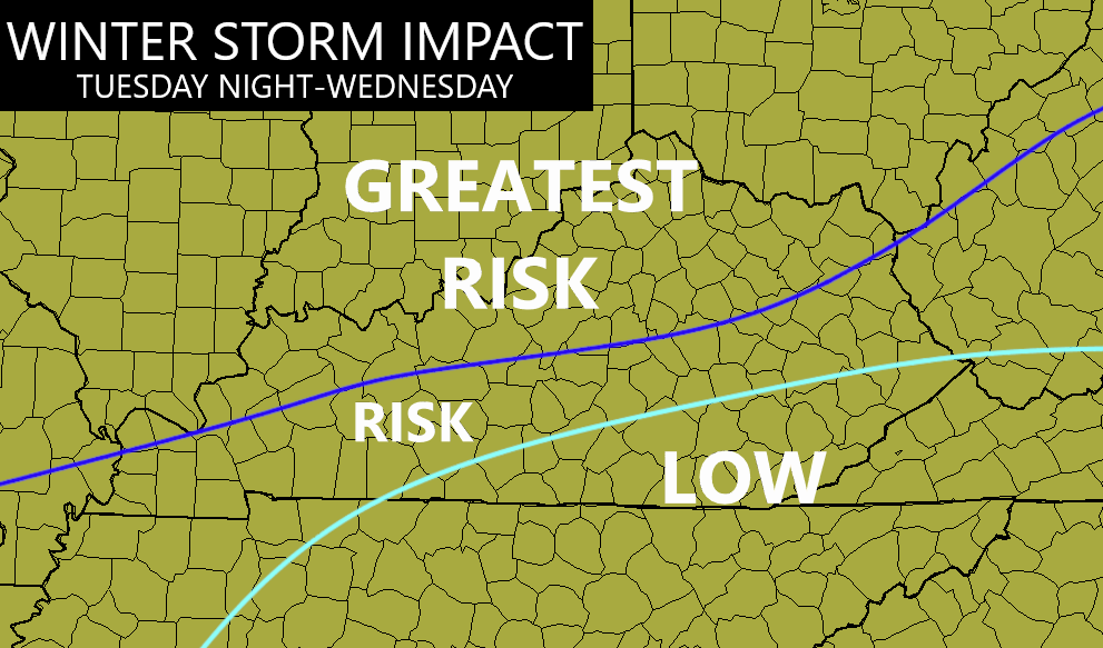
My area of greatest concern hasn’t changed…
I will update this and likely upgrade this to a WST on WKYT-TV starting at 4pm today. I’ll also drop by for an update here on KWC this evening.
Make it a good one and take care.

On the positive, us folks south of 64 will likely not need to shovel! Spin it as a plus!
BubbaG you are right on that. I just miss seeing a really good snow..I guess we all do. If I can’t get it in my area I hope some of you somewhere in Kentucky gets it. I think I will move to my sisters area of Indiana I checked her weather it says they could possibly get up to 8 or 9 inches of snow but I have a feeling someone in Ky is going to get a possible thumper as Chris thinks it may play out.
Crystal, Your area in Southeast Kentucky will normally receive the most Snow in the whole State because of your elevation. Hang in there those Snowy days will return.
Crystal i hope you get snow before the winter is said and done. I live here far part of western,ky by the Ohio river we may have a shot at it just depends how the track of the storm is.
Winterlover I hope you get the snow.
I don’t have a great feeling WKY will get a lot of snow from this. The plunge back into the icebox like we had at Christmas hasn’t happened… sure hope this isn’t a rain train for us!
Just learned from NOAA that there are more La Nina Winters than El Nino Winters which would explain all the lack of major Snowstorms in Kentucky. Records show it’s been going on for many years.
We did have the three record snows in less than a year, but that was eight years ago. Kind of fits your point.
If possible, could you include West Virginia interstate 64 for Tuesday Wednesday Thursday. Planning some travel.