Good Wednesday, everyone. We have a pretty ugly weather day across the region with rain, high winds and some snow. This is with a big winter storm that’s taking the worst of the weather just to our north, with more winter storm chances are lining up over the next few weeks.
Our day starts with snow and a mix in the far north with a quick change to rain. Whatever snow falls in this area will melt away fairly quickly. The rain train then rolls on for the rest of the state as temps spike through the day.
Here are your early day tracking toys…

Go to our weathercams page to check out the views from across the state…
Winds are a BIG player today across central and eastern Kentucky. Gusts of 40mph to 50mph will be common with the chance for a few spots to top 50mph at times…
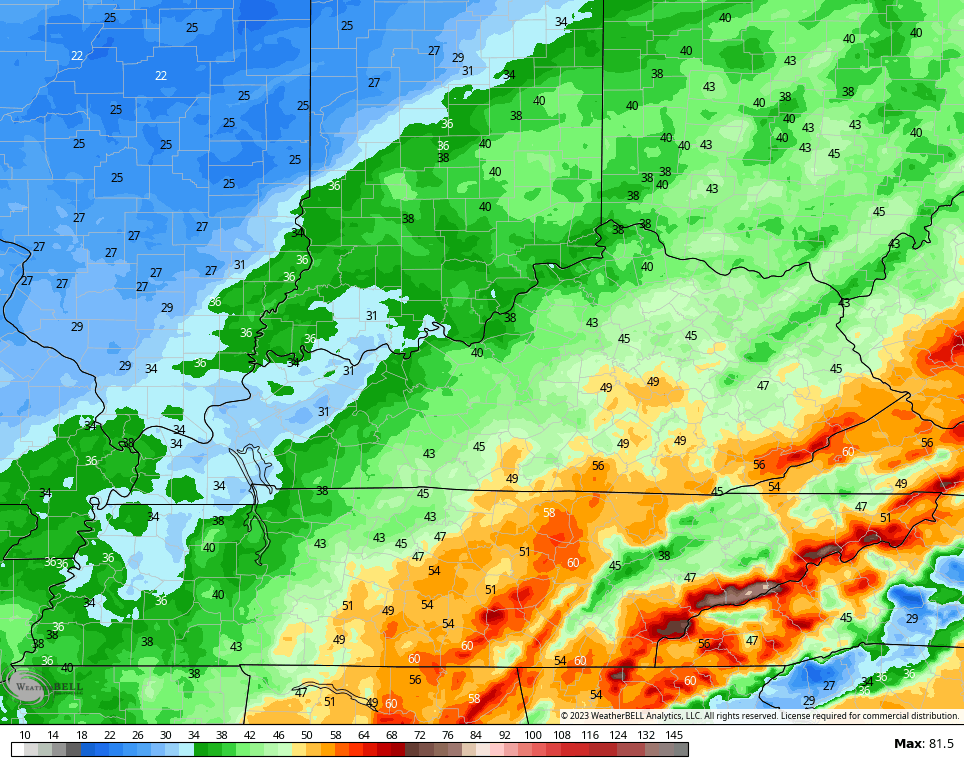
Temps spike on the strong south wind and then tank as the low passes by. That colder air then brings rounds of light snow with it Wednesday night through Thursday night. Light accumulations are likely with some snow days a good bet…
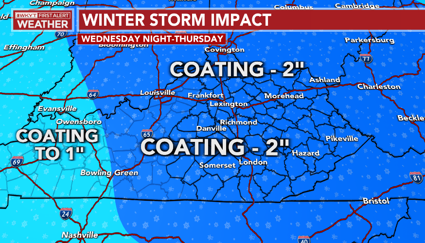
Snow showers taper early on Friday with a really nice looking Saturday in store. Beyond that, another system moves in with showers on Sunday and that may end as some flakes early Monday.
The setup next week is likely to feature additional systems working through the region with more forecasting headaches in determining storm tracks and precipitation types…
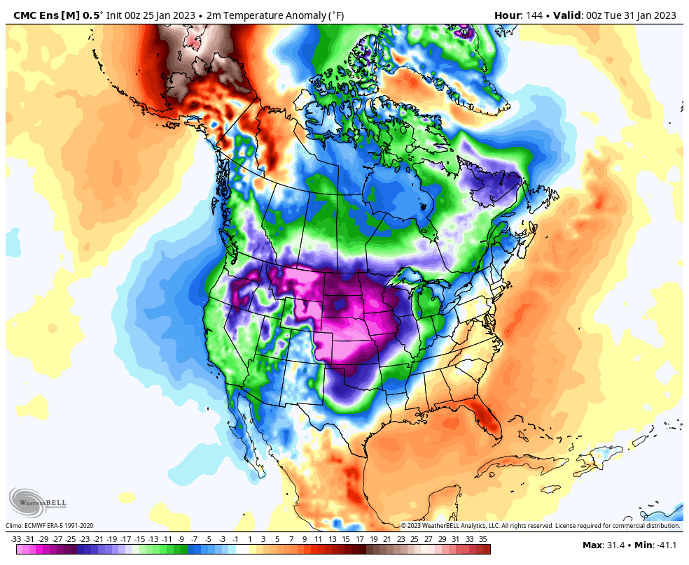
As this is happening, a very cold pattern develops as we end January and roll into the first 10 days of February. Look at how much of the country is MUCH colder than normal during this time…
I look at that map and can hear Elsa getting ready to start singing again…

My daughter, Wynter, told me to work that meme into my next post. That’s for you, kiddo! 🥶😁
I will have updates later today, so check back. Make it a good one and take care.

Here comes the ice, I am thinking about you Bubba.
Thanks Chris, we received 0.26 inches of plain cold rain in the past 48 hours. Currently we are in the dry slot and warming up today with the backside cold front coming later with a slight chance of Snow showers / flurries that usually amounts to nothing if it occurs at all.
The various weather models are useless in my opinion, but that’s the only tools we have for Meteorologist to make their forecast until a different way of forecasting the weather comes along in the distance future.
By the way this day on January 25th the Blizzard of 1978 occurred. Now that was a real Winter, which featured a 20 foot Snowdrift in my driveway. First time I experience a Snow cover that lasted through February and March. I had less damage to my nursery plants in those Winters and more damage this year with that dry Arctic cold. The frequent heavy Snowstorms in 1977-78 saved my plants by insulating them. If anyone knows did South Central Kentucky receive any Snowfall during the Winters 1976 through 1978 ?
More concerned about the severe weather season in the coming months than the Winter weather we may have in February and March. We will most likely have a late Spring freeze, but that doesn’t matter now, plant damage has already occurred.
Schroder, I for one remember those winters and we haven’t endure those type of winters since. Those type winters we had lasted through the whole winter season not the type of winter we get now gets cold for few days and warm for the next month like were experiencing now,
Winter Lover, do you remember if Taylor county received any Snow in those Winters 1976 to 1978 ?
No snow at all here in WKY
RIP SNOW
I’d say the snow in Dec is the best we’ll get here for this winter
Russell my county to date has received less than an inch this Winter. The most pathetic Snowfall of any place I ever lived. RIP Snow and Winter. #teamspring
It’s a Winter Wonderland here in the Chicago area! The snow overnight has stuck to everything, making it look like a picture postcard outside. I would estimate there’s around four inches of heavy, wet snow here in the SW Suburbs. I’ll know for sure when I go out to shovel later this morning. It’s still snowing lightly throughout the area. The computer models, by the way, did an excellent job predicting this snow for several days.
With temperatures predicted to rise slightly above freezing later today, some melting and compacting of the snow will occur, but with the colder pattern on the way, this snow is going to stay on the ground for quite a while. Plus, there’s several chances of more measurable snow here in the next week along with the colder air.
Winter is finally here for an extended stay.
Glad you received the Snow Mike. I bet you wish it was more than 4 inches. That’s my favorite kind of Snow. Heavy and good packing. Careful when you shovel the Snow and have fun. I see now that the various weather models are more accurate the farther North one is.
What kind of storm was this? It looked like it would be pouring rain all night based on radar and yet it only rained .20 of an inch… so even if it were cold enough it wouldn’t have mattered…..there would have barely been any snow.
Non phased storms. That’s the kind storms we receive in La Nina Winters.
Models sure honking ice starting In February timeframe..How much and where if any to be determined..Nothing like creeping slow cold shallow air oozing East to make a mess of things..lol