Good Sunday, everyone. We continue to track some light rain and light snow across far southeastern Kentucky to wrap up the weekend. From here, the focus quickly shifts toward an active setup that can bring a severe threat later in the week.
Today is really a tale of two different weather worlds across Kentucky. Much of the state will see a mix of sun and clouds and temps in the 50s. That’s the good part. The bad part is that brush with winter weather across the far southeast. Light accumulations are possible across the counties that border Virginia with temps only in the 30s.
Here are your tracking tools to follow whatever flakes show up in the far southeast…

JENKINS

PINE MOUNTAIN

PIKEVILLE

Monday looks like a pretty good weather day with highs in the 50s and a mix of sun and clouds.
Clouds increase Monday night and Tuesday with a few showers arriving on the scene from west to east Tuesday into Tuesday night. This isn’t much at all as temps stay mild.
The late week storm system is a problem…
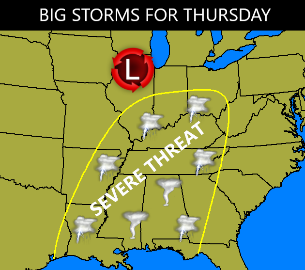
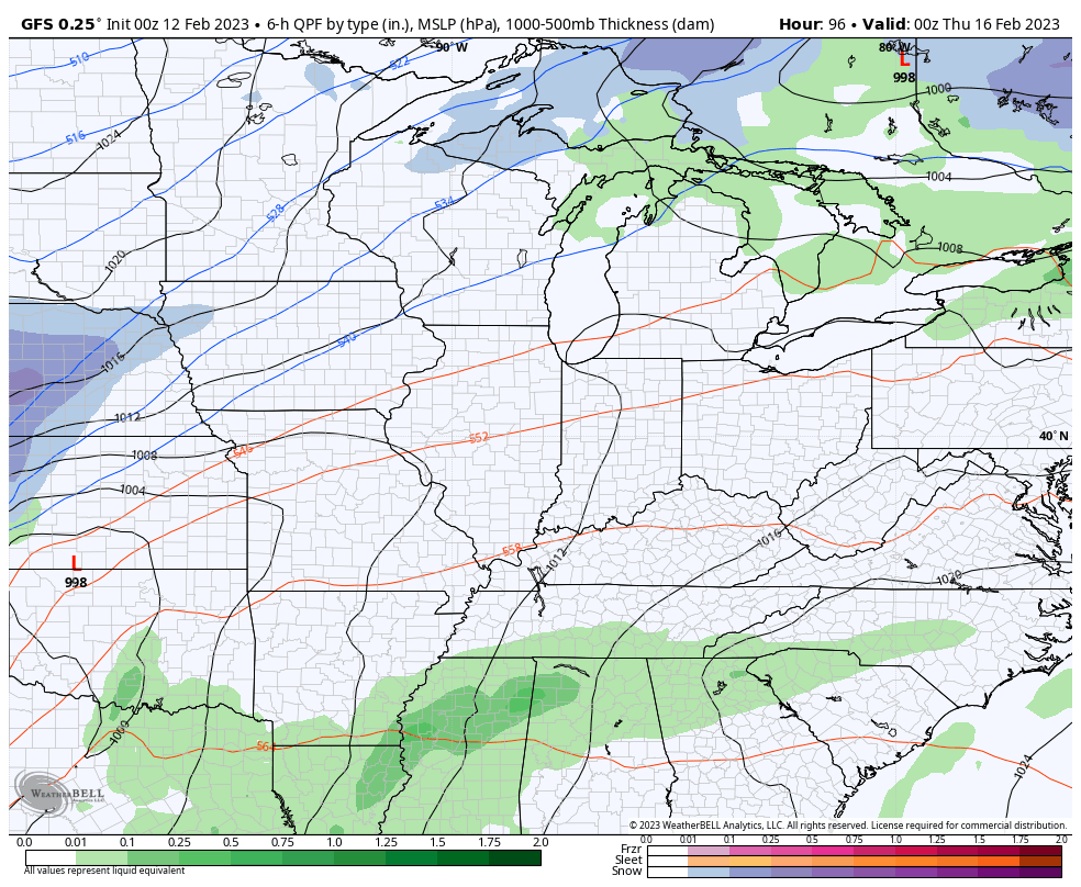
We may very well be dealing with strong to severe storms from the Ohio Valley into the deep south as we get a major clash of the seasons. Here’s the GFS for this time period…
With or without severe storms, high winds will be likely.
Temps may flirt with 70 ahead of this system and then drop into the teens for lows after it blasts through here.
In looking at the pattern for the next few weeks, this is a scenario that may play out on more than one occasion as this super active setup shows no signs of letting up.
I’ll see you kids back here with another update later today. Make it a great day and take care.

The latest jet stream forecast shows a strong Southwest to Northeast mid-level jet moving over western Kentucky during the Thursday night/Friday morning time frame. This coincides with what the Storm Prediction Center is describing as a very powerful upper-level system that will eject into the southern Great Plains on Tuesday from the Desert Southwest, and over the Ohio Valley/TennesseeValley area by Thursday. The addition of higher dewpoints during this period could significantly increase the likelihood for severe storms in our area.
https://twitter.com/derosajoe51/status/1624664948017094656?t=dC8hAuTIsKZEgpz1rP46QA&s=19
I hoping it will be just wind and showers like last week’s system. That jet stream map looks wicked. Thanks for sharing Joe.
In the Tropical Pacific, La Nina continues to phase slowly towards ENSO / neutral, but the Atmosphere has not changed with the increase in surface sea temperatures. Still a very much La Nina like pattern continuing to occur. The Southeast Ridge has not changed that much in strength and position. This pattern in my opinion will not change until the PDO ( Pacific Decadal Oscillation ) phases to positive from the long term of being negative since 2015.
Just read that the instability may be farther south for Thursday’s severe weather threat. Hoping this pans out. I ran the CAPE ( convective available potential energy ) and at this time predicted to be low for severe weather ( tornado outbreaks. ) With this said, everyone still must monitor the potential for severe weather this week by listening to Meteorologist Chris Bailey’s updates.
The latest from the Storm Prediction Center (Day 5 panel) indicates that they’ve extended the area where they expect severe weather to develop even further to the north, closely matching the jet stream forecast for the same period. It’s mid-Spring activity in mid-Winter!
https://www.spc.noaa.gov/products/exper/day4-8/
After I’ve gotten the weather out of my mine. I will enjoy Super Bowel Sunday. I suggest everyone do the same.
I hope you’re right about the severe weather later in the week Schroeder. And I too will be enjoying the big game tonight.
Happy Super Bowl Sunday! It should be a great game and lots of fun to watch!
In 2014 on Super Bowl Sunday, the Chicago area experienced a big snowstorm with over a foot of snow. Nothing like that today, with sunny skies and predicted highs near 50 degrees, and absolutely no snow on the ground.