Good Sunday, everyone. It’s another really mild day across the region and it only gets milder for the week ahead. As I’ve said for weeks now, this pattern is getting us into some trouble with too much rain. Unfortunately, we found that out in recent days and I think we have more of these days to look forward to.
There’s a lot of ugly with this pattern, so let’s start with some good.
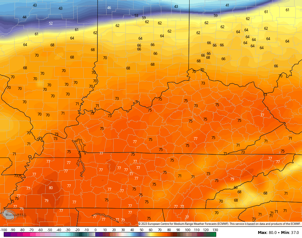
Temps out there today are in the 55-60 degree range for many and should be in similar territory on Monday. Temps hit the 60s for Tuesday and then may very well surge into the 70s for Tuesday and Wednesday.
The models are showing a serious temp spike on those days…
Ok. Let’s get to the bad part of the program.
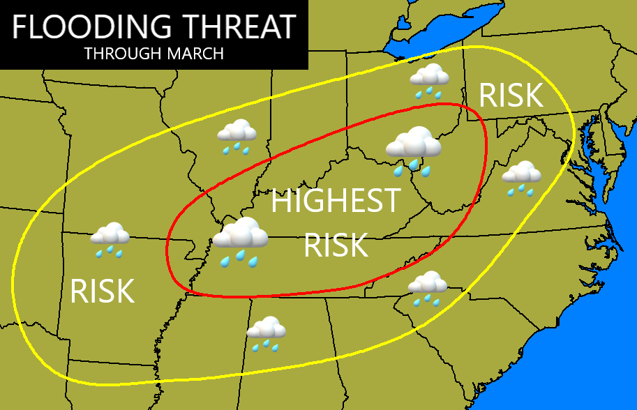
The pattern continues to be skewed much wetter than normal and this is very likely to continue through the rest of February and into March. I expect the bullseye to still be right on top of us during this time.
This isn’t a map I enjoyed making…
Some of that kicks off this week, but it’s not a washout of a week by any means.
Rounds of showers and a few storms will be noted from time to time. This animation starts on Monday and goes through the following Monday…
I’ll swing by with another update later today. Make it a good one and take care.

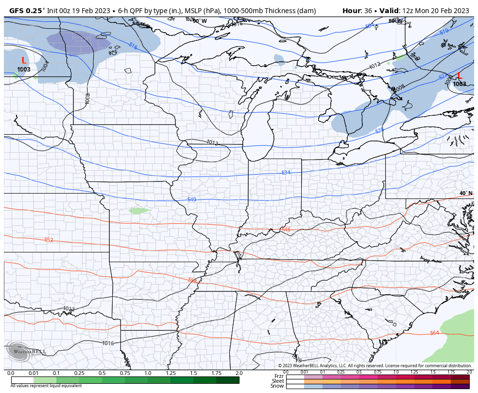
Conditions on Wednesday may be favorable for another round of severe weather. The high temperature is forecasted to be 76°F in South Central Kentucky, and will dip into the upper 30’s that evening. Once again, the lower leg of the jet stream will be positioned over western Kentucky producing significan shear, and dewpoints are forecasted to be in the upper 60’s to lower 70’s. As usual, a lot depends on how much daytime heating we get, and whether the southeast ridge decides to make itself known. Until it does, the battle zone between frigid and warm/humid will remain in our backyard!
March has arrived early this year.
Actually it started in mid-January.
Yeah, March weather occurred since January first. Maybe we will have January weather in March ?
The activity of the southeast ridge remains unpredictable, and it is certainly not behaving as we would expect it to during a changeover from La Niña to ENSO-Neutral. That may be due to the fact that despite sea surface temperatures steadily rising in the eastern equatorial Pacific, steering winds aloft are not cooperating, so surface conditions continue to exhibit the effects of a moderate La Niña. It is likely that we won’t see ENSO-Neutral conditions in play until late April/early May.
I’m concerned that when ENSO / La Nina reaches equilibrium that it will remain that way until next Fall and then return to ENSO / La Nina for a fourth Winter. The Southeast Ridge remains extraordinarily strong, but changes positions in the Southwest Atlantic from time to time. PDO remains a strong negative. Not likely to change anytime soon. We are to remain in this pattern till it does.
Don’t like the looks of that flooding threat map Chris but I am afraid we will see high waters through March and we have had some big floods in April the big one in 1977 that’s one I will never forget. I remember we lost everything and so did a lot of other people.
I don’t think we had the flooding rains in 1977 when I was living in Indiana. However, in 1979 we did. It was so bad the state of Indiana moved the entire town of English to higher ground.
I think the majority was southeast Ky but a couple other states were affected too
Twenty-two people died in the four-state region, including 10 in Kentucky, due to the flooding which also affected southern West Virginia, southwest Virginia and parts of Tennessee as the heavy rain continued through April 5.
According to the National Weather Service office in Jackson, record flooding occurred on the Tug and Levisa Forks of the Big Sandy River, the upper Cumberland River, the Guyandotte River, and the Clinch and Powell Rivers, with severe flooding also on the North Fork of the Kentucky River and on the Holston River.
The flooding led to 15 Kentucky counties being declared disaster areas, including Bell, Breathitt, Floyd, Harlan, Johnson, Knott, Knox, Lawrence, Leslie, Letcher, Magoffin, Martin, Perry, Pike and Whitley. Damage at the time was estimated at $175 million.
Major damage occurred along the Tug, Levisa and Russell Forks of the Big Sandy River. The city of Pikeville was estimated to have over $71 million in damages and lost revenue due to the flooding. Downstream in Floyd County, flood waters reached a depth of nine feet on Main Street in Martin, with one death, 117 businesses destroyed or severely damaged countywide, with nearly 1,000 families suffering losses.
WOW ! That sounds worse than the 1937 flood in Indiana.
The rains this past Thursday brought plenty of floods here in Wayne County, WV (and surrounding areas). Central Wayne county and down is super susceptible to floods, so that flood risk map is concerning. Areas are still working their way back to normal levels around here. Hopefully rains are spaced out enough to not wreak havoc.
The rains were so bad around here Thursday that some schools in the next county over couldn’t get home. I have a friend that teaches at one of the elementary schools in Lincoln and she got to work Thursday morning and was there for 36ish hours. Wild stuff.
https://www.herald-dispatch.com/_zapp/floodwaters-force-lincoln-county-students-to-spend-night-at-high-school/article_15c8228b-424d-59b8-bb03-70467aa51edc.html
The NAO has been positive for a long while. Indications suggest that by March first it will be on the negative side. This will bring in colder weather to the Eastern part of the country. Maybe a late Snowstorm ?