Good Monday, folks. It’s a very active weather day across our part of the world as another big wind maker blows in. This system will also bring the potential for a few strong to severe storms to start the week. I’m also tracking another big storm to end the week.
Here’s a breakdown of the day:
- High winds are likely. Gusts of 50mph-60mph will be possible
- Those are non-thunderstorm winds and could cause damage
- A line of strong to severe storms may roll from west to east across the state starting this morning in the west. That should exit the east by late afternoon.
- The best threat for severe weather will be across the northern half of the state.
- All modes of severe weather will be possible, but the primary player will be damaging wind.
Here’s today’s Severe Weather Outlook from the Storm Prediction Center…

Nice weather will move in behind this for Tuesday and Wednesday. Highs by Wednesday likely reach 70 or better.
This is ahead of a potent setup for the end of the week with two systems on the way. The first is the weaker of the two and brings showers and some storms in here for Thursday. The second system is a much bigger and stronger system as it moves in for Friday.
The track of this low will be critical in determining which kind of wild weather hits where you live. Flooding rain, strong storms, high winds and snow will all be possible, depending on where you live.
The GFS continues to be the farthest north with the track of the low…
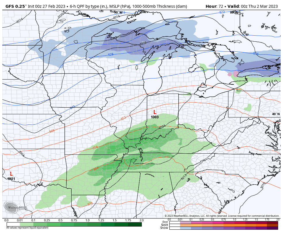
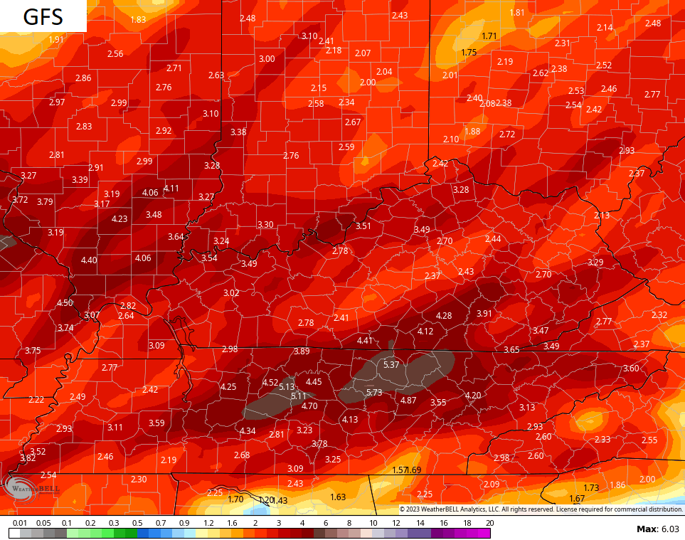
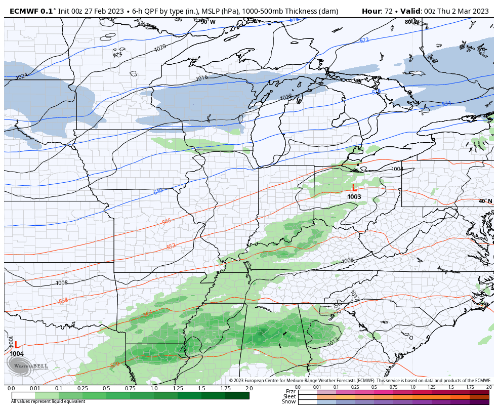
Here’s the rainfall map through this Friday…
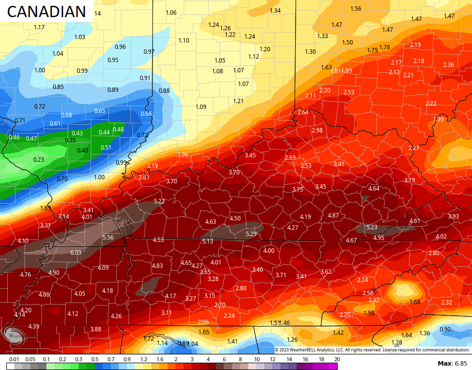
The Canadian is farther south with the track, bringing winter weather into the north…
Here’s the rainfall map from the Canadian…
The EURO has more of a GFS look with the low on top of us…
I will have updates later today and be on WKYT-TV for all your breaking severe weather needs. Until then, here are your storm tracking tools…

Current watches

Possible Watch Areas

Have a great Monday and take care.

We are closing down on one disappointing Winter. Maybe in the next few weeks a surprise Snowstorm will blanket the state. Then I will be ready for Spring weather without the severe weather threats.
Nah, I’d bet most of KY is done with snow on the ground beyond a coating. Richmond is looking at a record low, or tie for lowest snow for a season. Just looking at the models this year it is uncanny how the fence sits on top of KY. We’ve had some smaller snows, but not had a big one since the three record snows nine years ago. The big snow drought is real.
You are probably right Bubba about the chances of accumulating Snow on the ground before Spring arrives. I been living in Maple, Kentucky for only 14 years this coming July and have yet to see an impressive Snow event. I talked to the Folks that have lived here all their lives and asked about the Winters, and the reply was that the Winters are mostly mild with not much Snow. That would explain why there isn’t any Snow Emergency Route signs anywhere in Campbellsville. I don’t know about other communities in the State.
The Ice Storm in 2009 was impressive. Worse one I ever seen. Almost three weeks without electrical power. I kind of wonder if our Winter weather type here may be Ice Storms, and our Spring and Fall weather type is Tornadoes, and our Summer weather type is drought.
2003 was the worse ice storm I’ve seen in Lexington.
All of the years I’ve been watching weather, if the western 1/2 of the USA is cold/snowy – forget the eastern 1/2 (for the most part) unless you’re extremely north.. I also notice most of the lows are taking the same path (for the most part)..
FYI – I don’t drink tap water… It’s too bad we have to shower in it though
The models were correct about the above normal temperatures for Feb..
March is forecasted to be bellow normal.
So I am sure we will see more of these fence sitting snow chances showing up on the models.
Wouldn’t be surprised if this is the case all the way into middle of April.
If it can snow in San Bernardino it can snow here into May.
Remember to drink your bottled water if you get your water from the Ohio River. If Cinci shut-down their water intake why didn’t KY water systems. Too much heavy metals in the water from OH washing our way with all the rain. Bottled water everyone! Stay safe!
The majority of Ky. waterways feed the Ohio River.
All roads lead to Rome, All waterways lead to the Ohio River.
The reason why is political differences and I’m getting tired of it.
I use a Berkey water filtration system for everyday drinking water since I don’t trust what comes out of our tap.
DashConnely that’s good advise I have been drinking bottled water.
That toxic spill in East Palestine, Ohio has destroyed the environment to the point of no return.
Note or fun fact
Ky waterways are the only streams that travel north in the continental states. From what I read. Feel free to contradict me if I am wrong.
I hear the rain coming down as I type this. I hope we don’t get a lot of the high wind. I don’t like the looks of those possible rain totals coming. It always worries me where I live I can see the big sandy river then there is a fairly large bottom between me and the river and I am up a little on a hill while I have never been flooded here it’s got too close for comfort sometimes. I have noticed that each year the river inches up a little higher. I do miss the big snows from years ago too.
I’m in the hills. Flooding not a problem.
I’m still waiting for one of those big Snows, but I don’t think it will happen in my area of Kentucky.
Correct, Geography is one of my favorite subjects.
Test
This has been the most snow starved winter for ky I can remember in a long long time. Darn el nina/ Ridging. Meanwhile my wifes Hometown in Northern Wisconsin has close to 18″ of snow. Guess it’s time for a road trip if I want to see some decent snow this winter. Maybe next year ENSO will put us in a more favorable pattern
Well lets hope so. The Pacific has been warming up in recent days.
It’s 74°F at my PWS near BG, and I just recorded a 47mph wind gust! The latest SSTA chart seems to indicate bye-bye La Niña, finally!
https://www.ospo.noaa.gov/Products/ocean/sst/anomaly/
Wind gust up to 52 mph here in Maple.
It’s a cloudy, windy, and mild day in the 50s here in the Chicago Metro Area as more heavy rain moved through the area this morning, along some rumbles of thunder.
It’s been a sad winter for me. Practically no snow and lots of high winds causing damage. As much as I want snow, I think I’m just ready for winter to be over at this point.
Three things are a given in WKY…I guess Ky in general…
No snow-RIP winter
Rain trains
Lots of wind always
LOL…. very true Russell
Even with La Nina decreasing the same old weather pattern continues. It’s been three weeks of high winds and very little rain here in Maple. I don’t think Spring will be any better.