Good Wednesday, everyone. It’s a very busy start to the month of March with severe weather threats and high winds. The first threat arrives this evening, with the potential bigger show for Friday. That’s when another major low pressure rolls through the area.
Temps out there today will be in the 75-80 degree range for many and we could see record highs falling once again.
Instability increases ahead of a cold front set to arrive later tonight. This front will touch off a line of thunderstorms that may be strong or even severe. Damaging wind would be the main threat with this line as it goes up during the evening hours.
The Storm Prediction Center has not had this area in any kind of Severe Weather Outlook for today, but that’s changing…

This front brings in more stable air for Thursday as it stalls just to our south into Tennessee. That starts to move back to the north as a warm front this evening into tonight. Showers and thunderstorms will accompany this front as it lifts through and there’s the chance for a few strong or severe storms in the west before the evening is over. Here’s the Thursday Severe Weather Outlook from the Storm Prediction Center…

Friday is the day I’m most concerned about. A major low pressure wraps up in Missouri and then rolls to the northeast, just north of the Ohio River. That puts our region in the threat for strong to severe storms racing from west to east across the state.
Damaging winds and a few tornadoes will be possible with this setup. Here’s the Friday Severe Weather Outlook from the Storm Prediction Center…

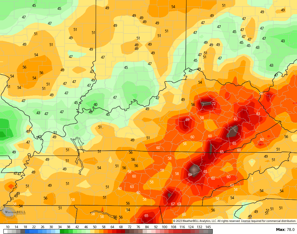
Winds will be a major player with or without thunderstorms. Check out this wind gust forecast…
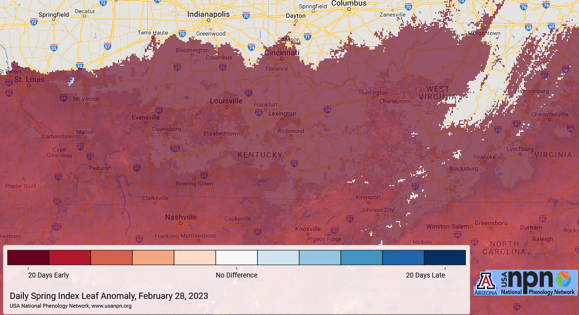
As you are well aware, this has been an incredibly early start to the spring season for our plants and vegetation. This map shows how most of the area is more than 20 days ahead of normal…
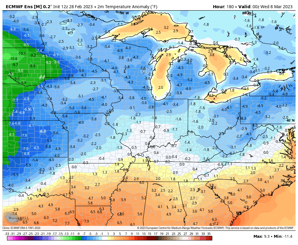
With the season this far along so early, plants and vegetation could be in a world of hurt with even normal March cold shots. The EURO Ensembles continues to show some significant cold in the second week of the month…
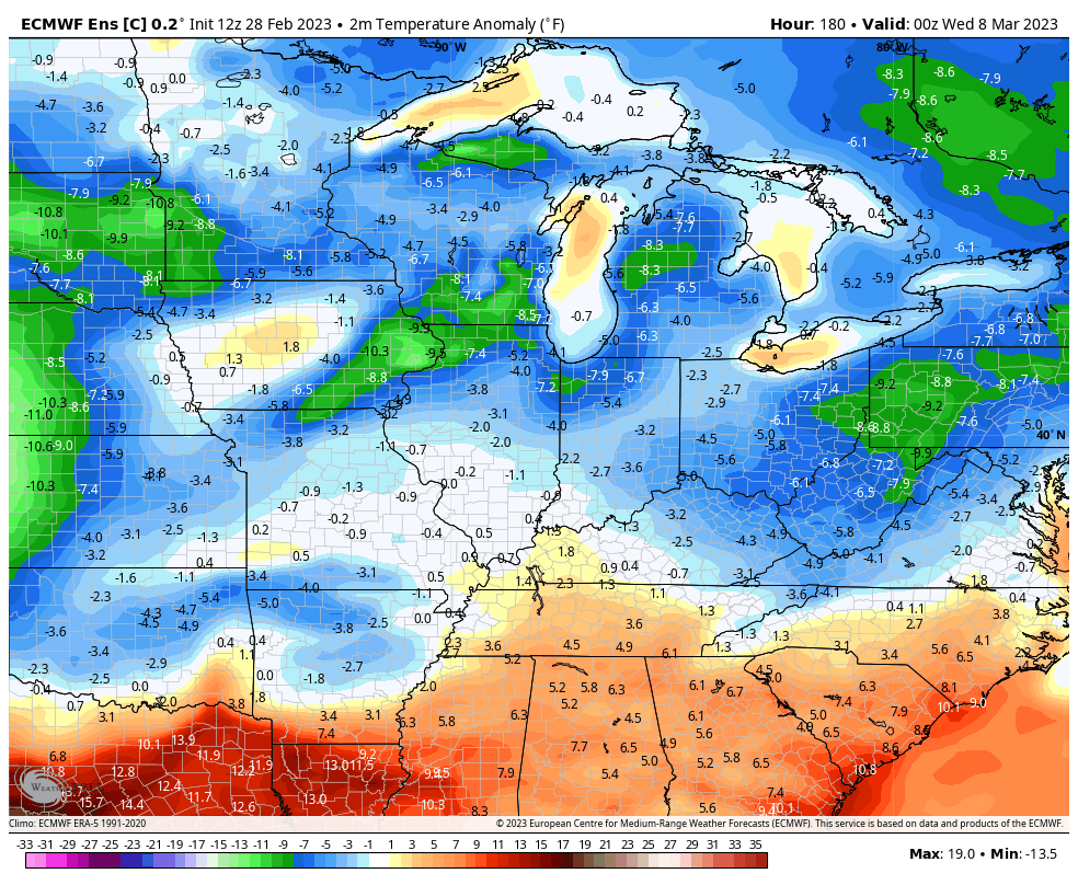
The Control Run of the Euro is even colder…
Nothing good can come from that.
I will have updates as needed and I’ll be on WKYT-TV with all your severe weather needs. Until then, here are your tracking tools for the day…

Current watches

Possible Watch Areas

Have a great Wednesday and take care.

Very true my lawn is near mowing stage.
Mowed mine yesterday Unbelievable cant remember a time when I had to mow this early.. Chris is right fruit trees budding on a road to blossoming,, only to to be zapped by march cold .and all of this wind/ no snow be glad to wave el nina goodbye and good riddance
La Nina wasn’t the only reason we had a mild Winter. The stronger than normal Southeast Ridge and a Polar shift were also at play.
La Nina winters cause the Southeast Ridge. It’s a hallmark of the La Nina because it won’t let the MJO get in favorable phases for snow storms in the East. So instead we get the extreme ridges in the East with troughs out West.
I don’t know too much about ENSO. It’ very confusing and I have no business discussing the subject. All I know is we just finished one of the least interesting Winter in my 71 years. I’m ready for the crappy Spring now.
We don’t have a lawn just fields of native gra*s*ses and various flowering native plants.
I bet that’s pretty Schroeder. Do you see many butterflies? I’ve notice they’re getting scarce around our Washington County farm.
Dottie, we have butter Flies and moths in the late Summer. Rabbits and Squirrels are absent. Deer are plentiful.
I miss working in the plant nursery business I had many years ago, but not when we had years with Spring freezes. It was a very sad Winter for those Kids who want Snow to play in. Maybe that will happen next Winter ?
Definitely not looking forward to the many weekly severe weather threats.
Reminds me of the spring of ’77
DashConnely I hope not that was such in awful flooding in my area of the state 1977 never forget it ever. You are right about reminding of 1977 and I am concerned about the flooding threats. As I type it says temperature is 79 degrees! Chris is right nothing good will come of this!
The Southeast Ridge could help out by limiting rainfall. Flooding would not be a problem, but I’m not saying it can’t happen. The same temperature here too 79 degrees.
The Southeast Ridge could help out by limiting rainfall. Flooding would not be a problem, but I’m not saying it can’t happen. The same temperature here too 79 degrees.
Posted twice. Sorry Chris.
Where I was in Indiana, the Spring of 1977 was short and very stormy. The Summer came in late May with Temperatures of 102 degrees and very little rain fell until October. Lots of Snow through the Fall and Winter 1977 – 78.