Good Thursday, folks. It’s a much calmer day out there, but that changes in a hurry as another major storm system moves in. This system brings the threat for high winds and severe storms for Friday. Once again, I don’t like the setup.
Let’s break it down:
- A warm front lifts northward across the state tonight and early Friday. Rounds of showers and thunderstorms will be noted with this boundary.
- Heavy rain may cause flooding issues for some areas and some of the storms may be strong or locally severe.
- A POTENT low pressure then works from Missouri into the lower Ohio Valley on Friday.
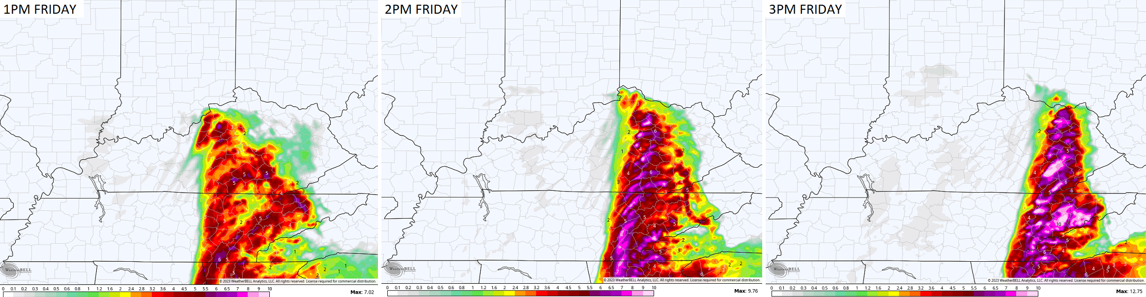
- This brings a line of strong to severe storms across western Kentucky during the morning. This line works through from Interstate 65 and Interstate 75 from roughly 11am-2pm. The line then works across eastern Kentucky and out of the state by 5.
- Damaging winds are likely with this line. Gusts may reach 60mph or higher with this line.
- There’s also the chance for a few tornadoes with this line.
- Non-thunderstorm winds will also be a problem as they top 50mph in several spots.
In terms of the severe threat today, it’s firmly to our southwest, but some of that may work into the far southwestern part of the state by late this evening. Here’s today’s Severe Weather Outlook from the Storm Prediction Center…

That risk then increases and focuses farther east across the state on Friday…

The tornado threat for Friday is one we have to keep a close eye on. The HRRR shows how the threat for a few tornadoes may increase as the line works into the eastern half of the state…
The models are spitting out major winds that would cause a lot of damge…
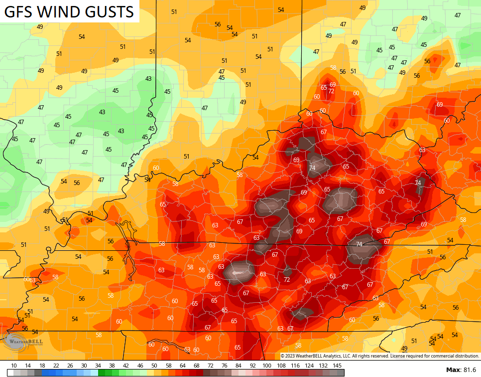

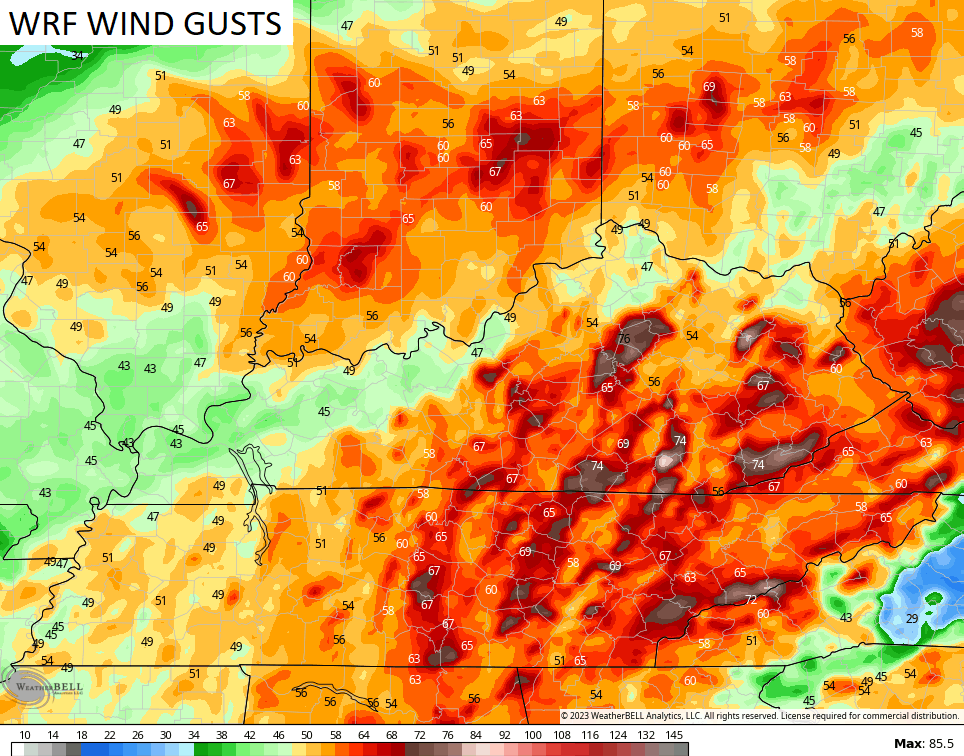
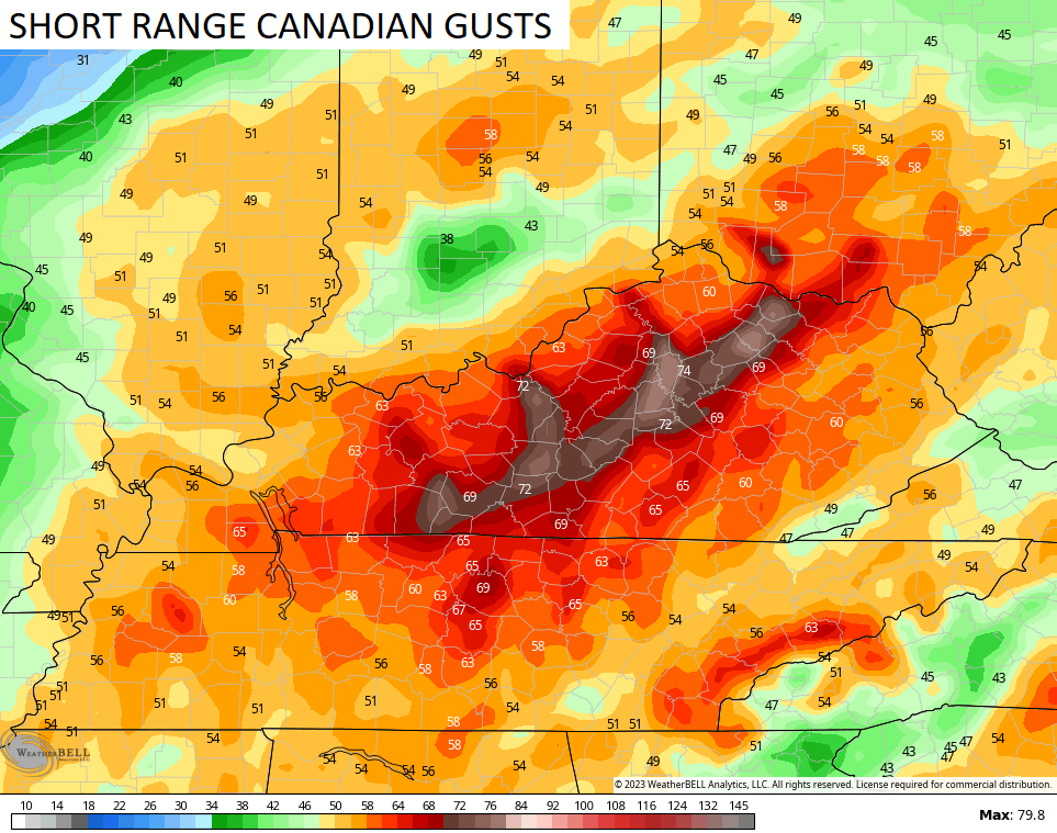
These are the highest wind gust forecasts I’ve ever seen models spit out in our region.
The weather for the weekend calms down with decent temps. We spike the numbers again early next week before changes kick in. These changes will lead us into a MUCH colder setup through the middle of the month…
I do expect some snow chances with this, too. Ugh!
I will have updates a little later on in the day. I leave you with the tools to track the severe storms threat to our southwest…

Current watches

Possible Watch Areas

Enjoy the day and take care.

what’s up with this wind?? Like every week 50 mph+ winds…
Exactly! Insane!!!
I think the high winds are going to continue until it causes major damage. This is why Spring is not my favorite season. Do we have seasons anymore ???
I cannot believe I haven’t lost my power to my home.
My home is usually the first casualty.
We haven’t lost power for a long while and the utility bills haven’t been that high. Will are luck run out as we get deeper into Spring ?
The series of storms we’ve seen over the past several weeks have gotten progressively stronger, with steep pressure gradients approaching what I’ve seen with nor’easters and small hurricanes. The extremely high winds don’t surprise me in the least, considering the pressure differential between these lows and the southeast ridge, and the next storm is supposed to have “historic” low pressure readings!
Several factors concern me regarding prospects for severe weather this Spring, which has been somewhat below normal over the past few year. Historically, in years such as this when we were phasing into ENSO-Neutral during the Spring months, there have been upticks in severe activity. Another factor is an increase in solar activity, which is scheduled to peak in 2024. In the past few years, the number of sunspots has risen dramatically, and recently solar wind velocity, which has a direct affect on upper atmosphere currents, has increased.
It bears watching.
I would rather go through a Nor’easter. More interesting weather especially if it’s Snow. Closes storm to a Nor’easter that I have been in was the blizzard of 78.
While in college back in the early 70’s, I would drive to a summer job on a road that paralleled the Jersey shore, with a 15 foot high seawall between the beach and the road. I was driving one night during a nor’easter in the lane next to the wall, and saw waves breaking over the wall, and land in the other lane. Terrifying!
Winter Storm Watches are now in effect for the Chicago Metro Area (except for the counties bordering Wisconsin) for Friday afternoon and evening with a rain/snow mix possibly changing to very heavy, wet snow along with 45 MPH NE winds. The tentative outlook right now is for 5 to 8 inches of accumulation.
The NWS is not very confident at this point though, and the computer models have been all over the place in regard to where the heavy snow will fall. The heaviest snow could still go well north or even shift a little further south. Temperatures in the 30s will complicate things also.
With the lack of snow we’ve seen so far this season, it’s hard to believe that we’re going to get anywhere near 8 inches of snow. This season, the computer models have been notorious for over-predicting snowfall amounts.
I think the chances of us getting a heavy snowfall out of this are about the same as Kentucky losing at home to Vanderbilt on Senior Night. Oh wait…that did happen! So maybe we will get a major snowstorm!
Hope you receive the Snowstorm Mike. I’ve given up on any Snowstorms here. Our total Snowfall was less than 2 inches. I don’t think next Fall and Winter will be any different.
I heard on Fox 41 Louisville that a ‘double red flag warning’ will be issued later today. I thought that was only at the beach?
Dash. I believe that you’re referring to a coastal Hurricane Warning, which is two square red flags, each having a smaller black square centered within. One of these flags indicates Storm Warning. A single red pennant indicates a Small Craft Advisory, and two pennants signals a Gale Warning.
https://www.weather.gov/marine/cwd
My barometer earlier in the week fell to 29.19 inHg with a max wind gust 59 mph . I remember during the Blizzard of 78 the pressure dropped to 28.80 which I believe is the current record. I lost a few small pieces of roofing earlier in the week might as well wait till this wind maker goes by before I clamber on the roof might not have a roof to clamber on. I think snow lovers will enjoy the next couple of years. And Joe as you mentioned about the sunspot activity nearing max As a Ham radio operator the DX has been great . At least something positive.
Why do you think that Snow Lovers will be happy in the next few years ? I don’t find this happening.
I’m afraid that an EMP will take out the Grid. We been threatened by a balloon.
I read that the reason for so many ENSO / La Nina events is that Antarctica has lost a lot of Ice and is keeping the Pacific Ocean colder than normal. And the Polar low is on the other side of the Earth in Siberia. I wasn’t a believer in Climate Change, but I kind of wonder now. I remember Honey Bees, Rabbits, Squirrels and certain bird species in abundance in my lifetime and now not.
My County is now in the highest risk for a Tornado outbreak tomorrow. If a Tornado ever damages my home and I survive the storm I’m leaving this awful climate.