Good Thursday, folks. It’s a much better weather day across the region, but changes are in the works for later tonight and Friday. This comes from the first of two systems set to impact our weather through the coming weekend. Both of these may throw a few flakes in here.
Temps today hit the mid and upper 50s for many with a 60 possible in the west and south. Clouds will increase with showers arriving from west to east this evening. Those showers zip in and out of town fairly quickly into Friday morning. Temps then crash behind this system through the day. A northwest wind flow behind this may spawn a few flurries and snow showers from Friday evening into very early Saturday morning.
The Future Radar from the HI RES NAM shows this action…

Skies become partly sunny on Saturday with seasonably chilly temps. This is the day to get out and enjoy because we have another system moving in on Sunday. This brings rain and some snow to the region, with the chance to put some snow on the ground across northern Kentucky.
That will be followed up by a strong northwest wind flow with a few flurries and snow showers into Monday and Tuesday. Here’s how the GFS sees this whole setup…
The Canadian isn’t as bullish on the Sunday snow in the north…
The EURO has a little bit of snow in the north…
Regardless, temps are much colder than normal with this system…
We aren’t done with that one. Check out the next blast of cold coming behind that…
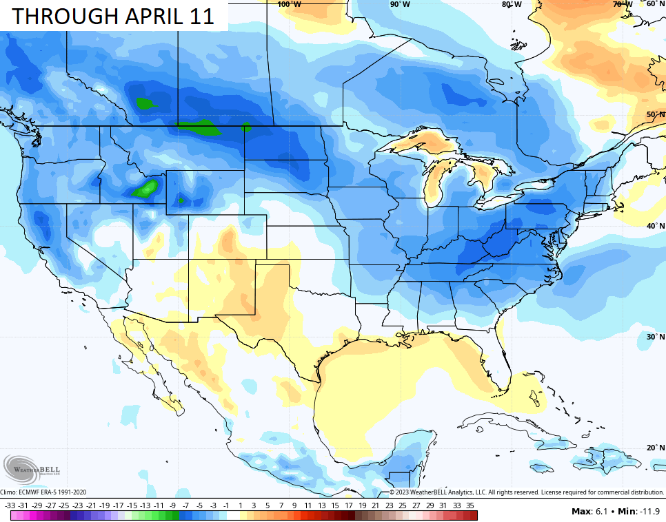
This is likely setting the stage for another colder than normal spring. Here’s the GFS Extended through April 11…
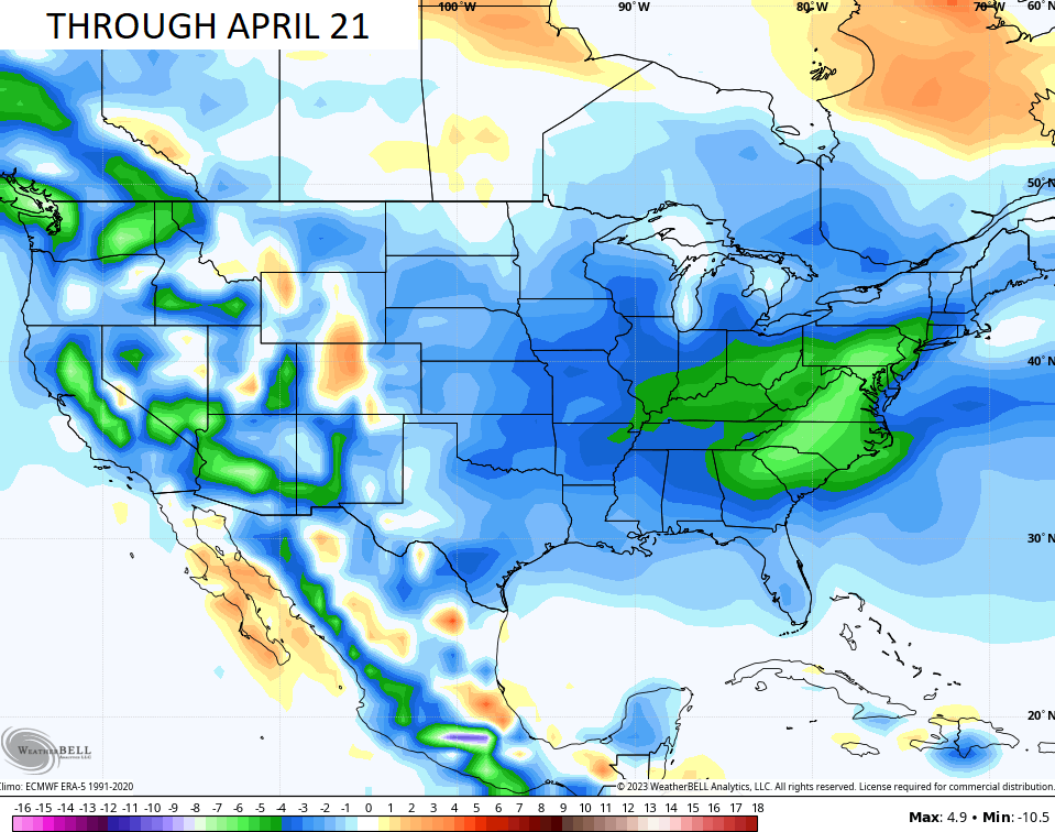
The CFS goes deeper into April and has a colder look…
I will have another update later today. Until then, let’s track some showers in from the west…

Have a great day and take care.

UGH!!! That’s pure ugly but par for the course the past several Springs(Non). All my broken bones, surgeries, metal, and stimulator are kicking ol Arthur In to high gear. Gonna be fun. Not! 🙁
I have aches and panes every time the barometric pressure changes.
pains not panes. dumb mistake.
I think no one is surprised honestly… We can’t have a non-winter in Jan/Feb and expect to just truck into spring with flowers blooming, birds singing, warm with sunshine all around.
I can’t remember when we had a Spring with all flowers and calm, warm weather without any harsh weather events.
Festive Flakes season is back in full bloom.
Hardy a Snowflake in my area this Winter.
So sad you don’t know what you been missing.
I meant hardly not hardy. Another dumb mistake.
I don’t trust long range models.
I never did.
The weather won’t stabilize until late April. Red Maple is blooming now. My allergies acknowledge this. Would still like to see a late Snowstorm. West Coast Mountains still receiving trains of Snowstorms. Some areas have received fifteen feet of Snow the past several weeks. Not a ENSO / neutral like pattern. Southeast Ridge still dominating despite the demise of La Nina.
Do you think we will ever get rid of the Southeast Ridge?? My temperature is saying 64 degrees.
Southeast Ridge remains, and in my opinion it is artificially being amplified to cause a damaging climate so the enemy can their ” Climate Change ” agenda through.
Here’s the temperatures in one of the Snowiest parts of the country. Doesn’t have to be very cold to Snow. A very common misconception.
https://www.ventusky.com/truckee
We are now in ENSO / neutral, but NOAA cannot issue an El Nino Watch just yet. Which means that there is a 40% chance that La Nina could come back for a fourth year. I think that when the PDO goes positive we will have ENSO / El Nino. Then we will have a better chance of Snow events next Winter here in Kentucky.
https://www.climate.gov/news-features/blogs/enso
Here is the complete ENSO discussion:
https://www.cpc.ncep.noaa.gov/products/analysis_monitoring/enso_advisory/ensodisc.shtml#:~:text=Synopsis%3A%20A%20transition%20from%20La,Ocean%20%5BFig.%201%5D
Regarding La Niña, I feel like singing
“Ding dong the witch is dead
Which old witch
La Niña witch
Ding dong the wicked witch is dead!”
…but I’ll resist the temptation.
Based on sea surface temp. anomaly data and comments from several climatologists, I seriously doubt that La Niña will rebound for a 4th year.
I think that should be the song of the day Joe as Rolo says. I would add and it can take that southeast ridge with it.
Absolutely!!