Good Sunday, everyone. As we get set to put the wraps on our frigid weekend, we look ahead toward changes for the week ahead. These changes will warm our temps up and that will likely mean an increase in late week rain and storms.
This pattern looks very active!
Temps today start in the teens for many and end with highs in the 30s with a mix of sun and clouds. This cold hangs into Monday as we start things out around 20 before recovering into the upper 40s and low 50s.
The numbers climb by Tuesday and Wednesday and that climb means a few showers and storms rumble through. That looks to kick in for Wednesday with scattered stuff for Thursday as temps take off. These increasing temps will be ahead of a strong storm system likey to roll from the Mississippi Valley into the Ohio Valley on Friday.
The end result could be some big winds, strong storms and heavy rain…
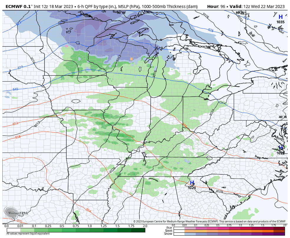
That’s a setup to watch as we will pop a southeast ridge ahead of that system. This appears to be the first in a series of storm systems set to roll across the country for the final week and change of March and into early April…

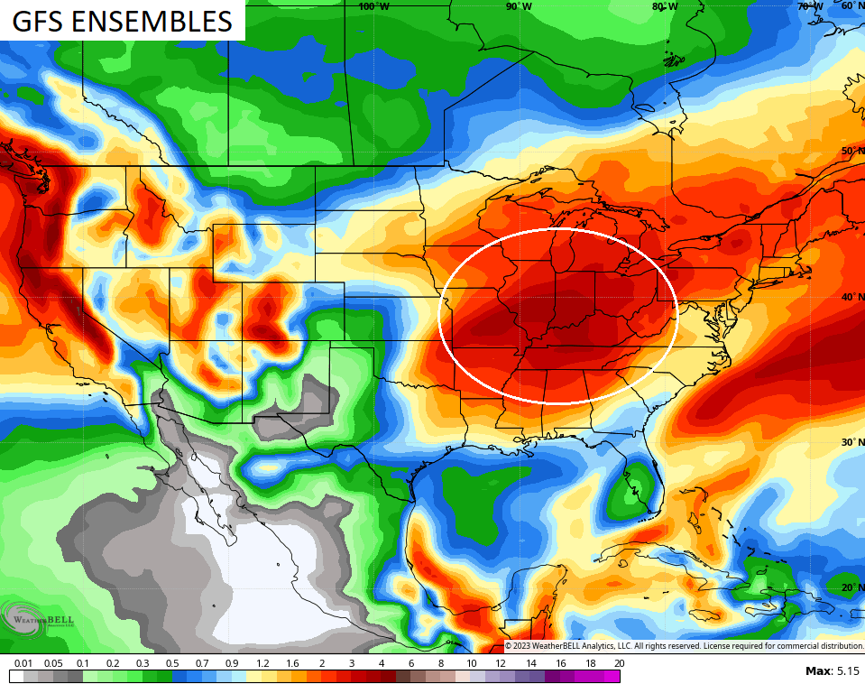
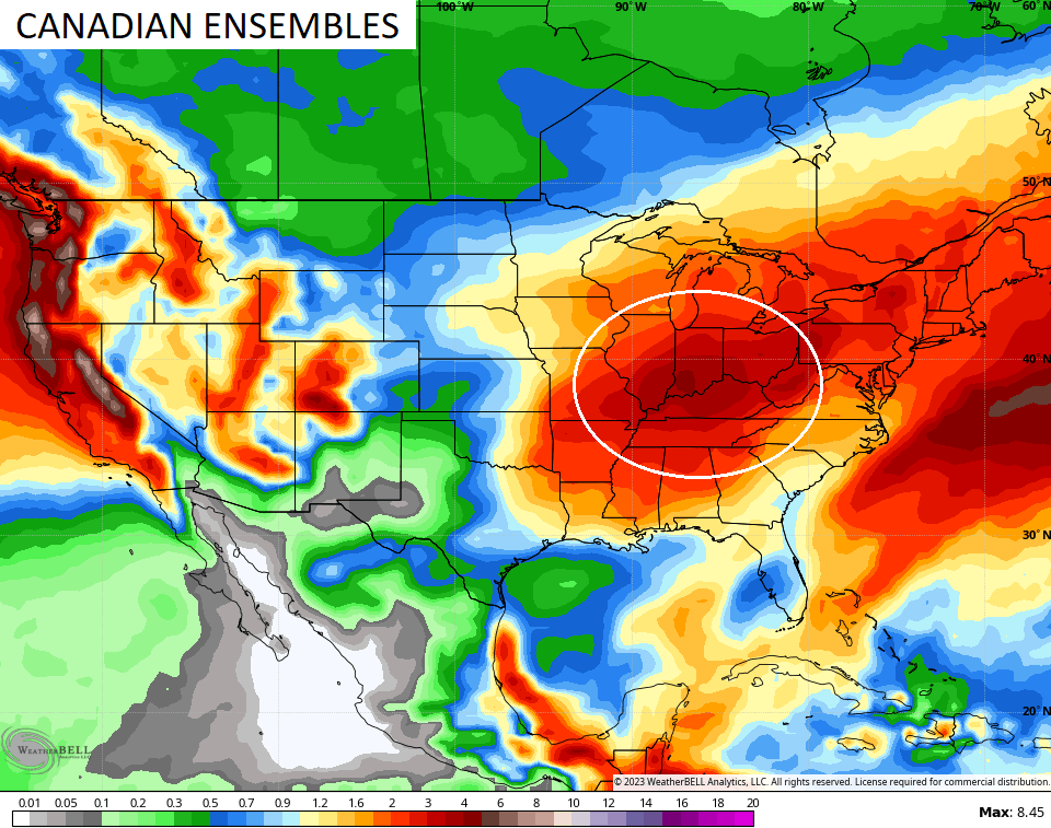
This setup can put down a lot of water across our part of the world. Notice how all the ensembles have the bullseye of heaviest precipitation right on top of us over the next two weeks…

All of this is likely to come with a temperature pattern that skews cooler than normal deep into spring.
I’ll take a more in depth look at the spring ahead with my Monday update.
Enjoy the rest of the weekend and take care.

Since I moved here August 1996 – this winter may be the worst winter (meaning lack of snow) that I remember….Even in winters where we didn’t get much snow, even those winters we had at least a couple of 2 to 3 inch snows… I’m thinking this must be in the top 10 of least snowy winters
Grateful that there will be a couple of decent days this week.
I was done with it a long time ago about wishing or hoping for at least one measurable snowfall. MarkLex
Very cold out and some snow showers flying festive flakes
Crystal, we haven’t had any Snow flurries here in South Central Kentucky for years now. I can only remember two times when we had our driveway cleared of Snow in the last 15 years. We will have to wait until next Fall and Winter to see if we have the expected weather pattern change ? At the present NOAA is not indicating any change. UGH !!!
Schroeder I hope the pattern changes for all of us next winter wow you haven’t even seen a flake. That’s wild. Do you Schroeder or anyone see a break happening between this going back and forth soon?? I mean to just have steady weather for lack of a better turn I feel like a ping pong lol. Back and forth I guess we all do.
We had a quick burst of snow in Richmond Kentucky this morning. I looked out, and our parking lot has patches of snow from where the wind kind of whipped it around like a blizzard. I wanted to see it, and I missed it, darn it. Oh well, lol.
It’s a given that Lexington and points East receive the best chances for Snow due to their geographical location. Best chances from Lake Michigan fetches. Western Kentucky is the other area that receives Snow when we have El Nino Winters. Central Kentucky receives the least Snow because it’s in the path of the moisture bearing low pressure systems ( dry slots. )
Schroeder, I’m in Greenup Co. close to the river and a lot of chemical plants to our west. There’s always a donut hole in this area. I think all the pollution keeps us from seeing much snow.
I’ve talked to a few guys older than me and It didn’t use to be like this. I was born in 73 and barely remember the blizzard of 77-78? I know we had no power for weeks.
Then the Blizzard of 91, we got 30+ Inches and wind-driven snow heavily for over 24 hours. Then the last good one was in 92.
Seems like one time in the past 20 years we’ve got over a foot. Maybe an inch or so this year.
My body is ready for summer, I’m too broken down for this back and forth and system after system. The Wx effects me badly. UGH!
I hope with the warmers days ahead you will feel better. I have some theories that may explain why the weather is the way it is now. I notice the Polar Low is shifting more often than it has in the past. The Polar Low this Winter has shifted more South towards Siberia, given those areas including the Pacific a colder than normal Winter. Hopefully, it will move back to it’s original position for next Fall and Winter ?
So true. The brief snow just left as fast as it came
The effects of pressure changes on chronic pain sufferers is real. Those individuals have had it especially bad this year, and the prospects that they’ll find relief from pain this year is not good at all.
The possibilities for a severe weather outbreak this coming Friday are increasing, and the SPC has already pinpointed a riskk area from the Gulf Coast through the Tennessee River Valley, including the South Central Kentucky region.
Yes I hurt too due to pressure and temperature changes. Be glad when the temperatures stabilize. Severe weather anymore seems to be our main weather type.
I hope no severe outbreak but I bet they will be. I also hope no flooding. I hear you about the weather change my one knee lets me know lol. It seems like we skip spring or something each year going from our so called winters to summer. I miss all the normal seasons.