Good Monday, weather weenies! We’re starting out a new work week on another colder than normal note, but we are coming out of it. Our pattern warms, but when it warms, it storms and we have storms in the forecast later in the week.
Temps today start around 20 and finish in the upper 40s to low 50s for many. Skies will be mostly sunny.
The numbers reach deep into the 50s for Tuesday as clouds thicken during the afternoon. Those clouds are ahead of warmer air arriving by Wednesday and Thursday, and this will be accompnaied by a few showers and storms.
This is all ahead of another potent storm system targeting the region by Friday. The track on this low means temps may surge to 70 and this could put us in the risk for high winds and strong storms…
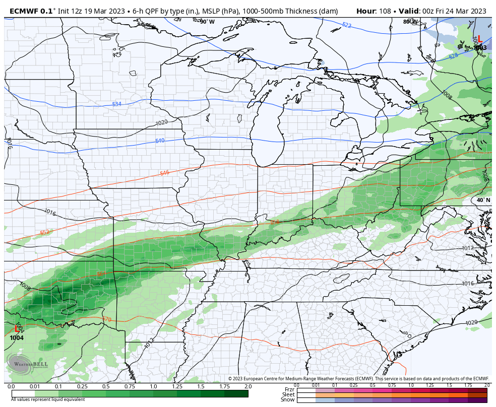
Not only am I concerned about strong storms, but this is also a pattern where repeat showers and storms could soak the region. The models are spitting out some hefty numbers around here through Saturday…
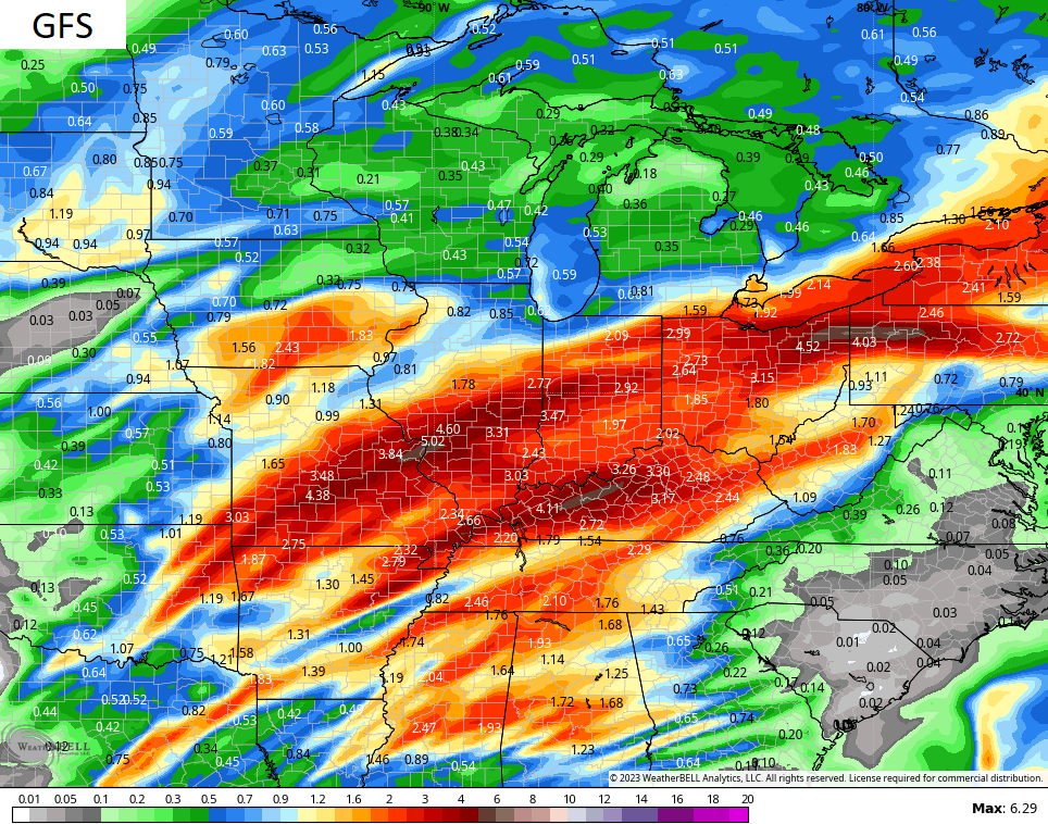
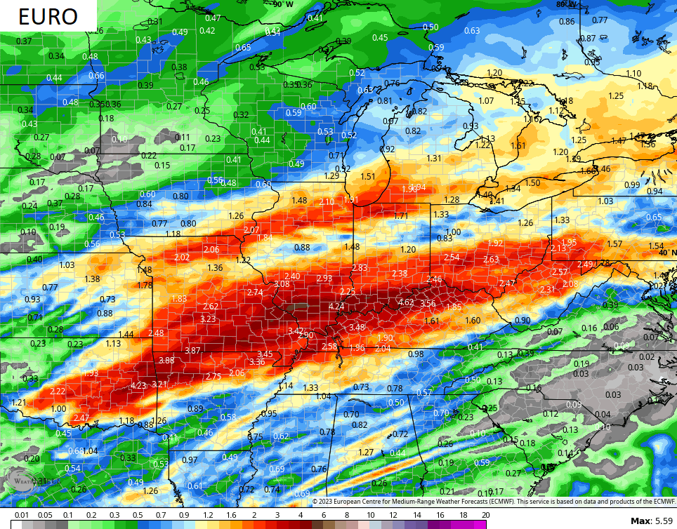
This is exactly where the Ensembles have been showing for a lot of precipitation. The battle zone between spring and winter is setting up in our region and that can get us into some trouble if we aren’t careful.
We have officially come out of a 3 year La Nina and it got me to thinking about all the extreme weather we’ve had in Kentucky during that span. Just off the top of my head:
- Historic Christmas Eve snowstorm in 2020
- Historic back to back to back ice storms in February 2021
- Historic river flooding in March 2021
- Historic tornado outbreak across western and central Kentucky December 2021
- Record warm Christmas 2021
- Tornado outbreak New Year’s Eve/Day 2021/2022
- Historic flooding in eastern Kentucky July 2022
- Historic cold/wind chills and blizzard conditions that shut the state down leading up to Christmas 2022
- Historic warmth of the rest of the winter of 2022/23
- Several damaging wind events over the past 5 months
- Historic hurricane force windstorm of March 3, 2023
Those are just the most extreme events I could think of. Obviously, we had numerous other wild events over this same period.
The equatorial waters in the Pacific are warming and are now into a neutral phase. When looking at these waters, I was struck by just how much of our oceans are now much warmer than normal. This map is astounding…
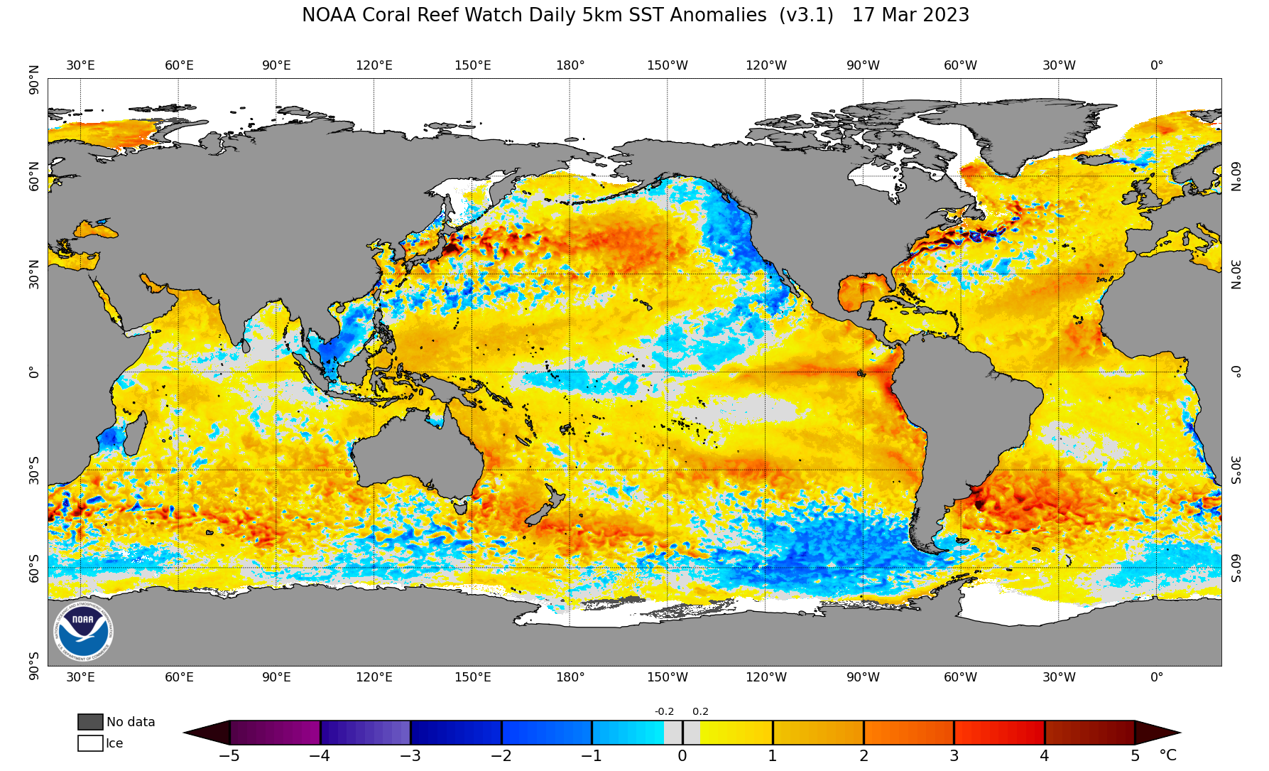
Notice all the above normal water in the Gulf of Mexico. That’s likely to play a role in our spring as it can provide storm systems with ample moisture, warmth and instability to produce an active severe weather season. That also means we are likely to see above normal rainfall with the potential for flooding issues from time to time.
So, the La Nina is over and now comes El Nino. The probabilities grow from late summer through fall and early winter…
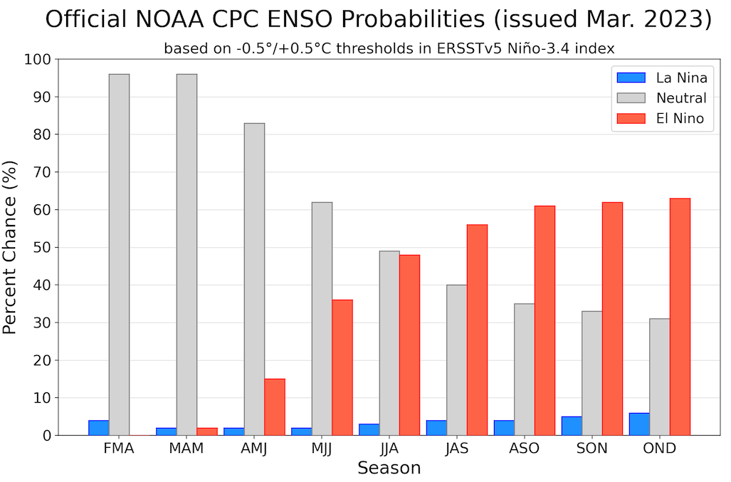
Since 1950, there are only two other instances of a 3 year La Nina being followed by an El Nino… 1976 and 2001. 76 was just a flat-out cold year that led into a historically cold and snowy winter. 2001 didn’t feature much heat at all, but led us into a much warmer than normal winter with two January snowstorms.
Make it a great Monday and take care.

Thanks Chris I dread the high water amounts that are possible. Does this mean by being in El Niño that we. can look forward to maybe some decent snow next winter?? I hope we can!!
No matter what type of Nino is running the show we will still be on the fence.
The location of the pesky southern ridge is still the #1 factor. IMOP
Thanks Chris. Interesting blog this Morning. I will not comment on what phase of ENSO we will be in this Fall and Winter. I remember several years ago you called me out that ” I literally new nothing about ENSO. ” I agree. ENSO is a very difficult subject to study and understand. I’ll wait until you bring out that NOAA has issued an ” El Nino watch. ”
Today is the last day of Winter and another Winter not to remember. I miss the Winters of the past in Indiana where we would have mild days followed cold Snowy days despite what phase of ENSO we were in.
Our atmosphere is warming, and whether that increase is due to changes in solar output, or increased amounts of CO² and methane is irrelevant. The bottom line today is that a warming atmosphere is changing the rules that define “normal” weather, making conditions less predictable and more chaotic.
All the reasons one can throw at today’s World climate are just theories and not scientific fact. I for one have seen changes in just the past 60 years. It’s not the way it was then and now. Can’t define weather / climate as normal or not normal. One may call it Earth changes due to Man or Nature, Take your pick neither answer is right or wrong.