Good Friday, everyone. Severe thunderstorms and high winds are threatening the region today and tomorrow as another in a long line of storm systems rumbles through. This is a fitting end to a March that has been the windiest month in recorded history for our region.
A few rounds of showers and booming thunderstorms are rolling through the area early today. This stuff becomes more scattered into the afternoon as skies break and temps surge. Readings reach the upper 60s and low 70s for many.
At the same time, a line of strong to severe thunderstorms is developing west of the Mississippi River. This will likely bring damaging wind and tornadoes to much of the Mississippi Valley this afternoon and early evening.
That line of severe storms then moves into western Kentucky early this evening then races eastward late evening into the wee hours of the morning. Once again, damaging winds and a few tornadoes will be possible, especially across the western half of the state.
Here’s the latest Severe Weather Outlook from the Storm Prediction Center…

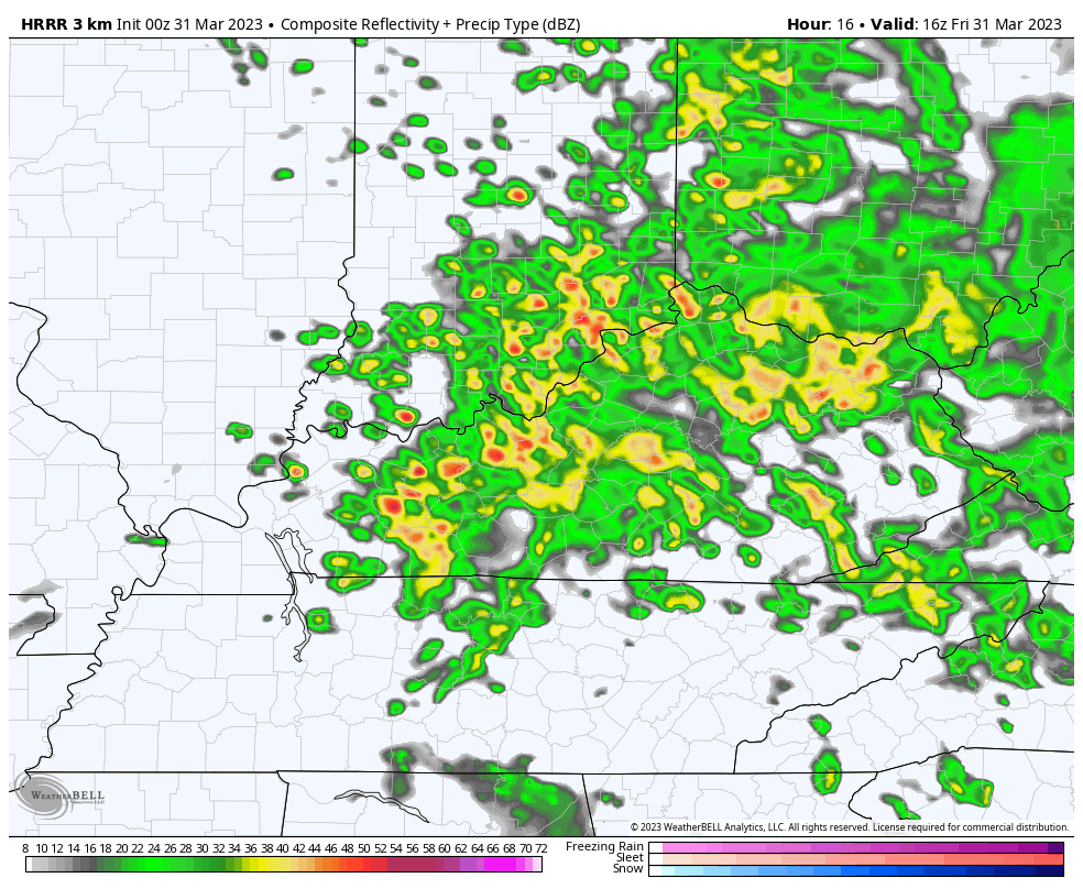
The Future Radar from the HRRR shows the initial rounds of storms early this afternoon ahead of the line of strong to severe storms…
Once that line goes through, high winds are a BIG concern for Saturday. Gusts of 50mph-60mph will be possible across central and eastern Kentucky.
The HI RES NAM is showing some serious wind gusts…

The NAM also has some 60mph gusts…

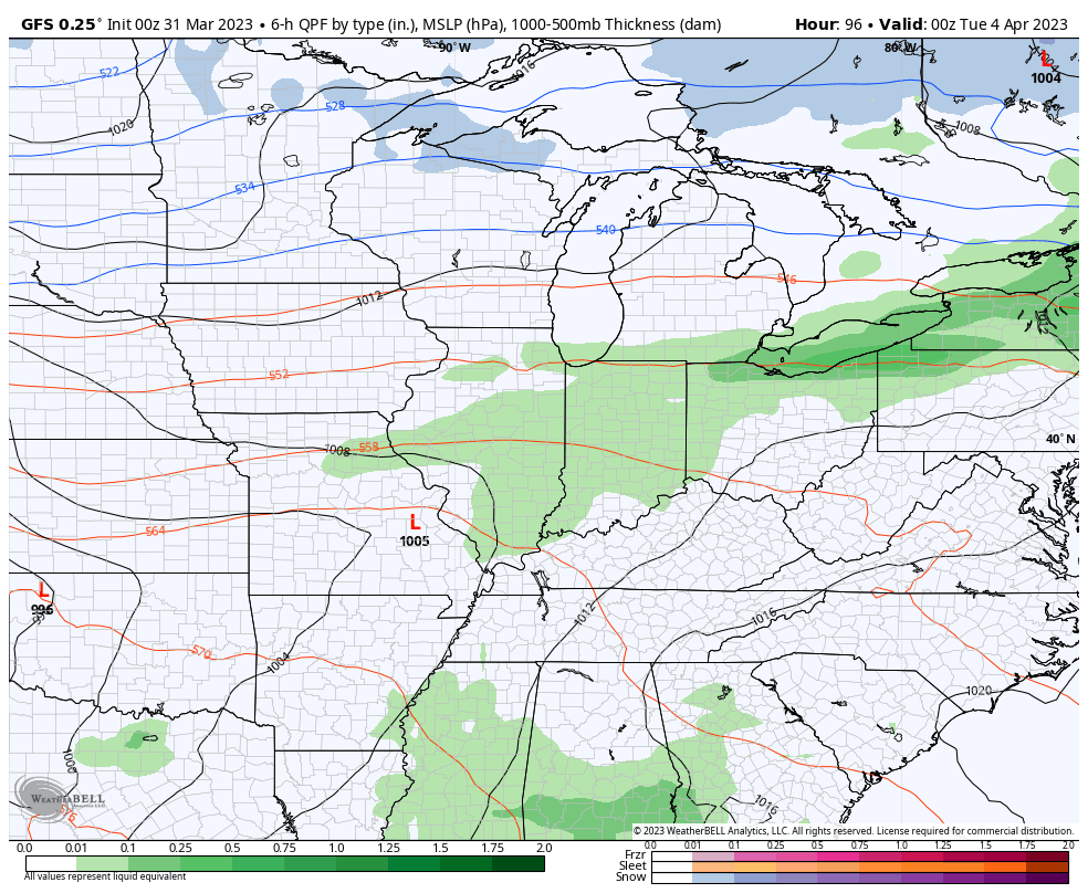
As does the GFS…
Wind damage is a good bet Saturday across central and eastern Kentucky.
Cold winds then kick in from northwest to southeast Saturday afternoon and that drops our temps. It may also bring in a few rain showers with the outside chance for a few flakes to show up in the north and northeast Saturday evening. You can see that on the future radar…

That’s not an April fool’s joke, either. 😡
Temps Sunday start in the 20s and climb into the upper 50s and low 60s. That sets the stage for a major warm surge into the first half of next week. Temps may make a run at 80 degrees during this time.
That may also come with a price as we run the risk for rounds of strong to severe storms, especially later Tuesday and Wednesday…
I will have another update later today and I’ll be on WKYT-TV. As always, I leave you with your severe weather tracking tools…

Current watches

Possible Watch Areas

Have a good one and take care.

Warm front coming through at this minute with moderate showers. Hoping that we have cloud cover throughout the day to lessen instability, but the gradient winds will still be there. UGH !!!
March isn’t going out like a lion today, it’s going out like a pride of lions! South Central Kentucky is in line to see some serious storm activity today. There is abundant shear available, and though CAPE values will be limited, supercells are possible, especially west of I-65.
The NWS in Louisville hosted an extremely comprehensive, advanced storm spotters webinar for Skywarn members last evening. The over 2 hour presentation covered detailed storm identification techniques, plus tips on valuable sites and tools. The good news is that it was recorded, and NWS plans to put it on their YouTube channel shortly. I’ll post a link as soon as it’s available.
Thanks Joe. I would appreciate that information.
The SPC ha updated their threat chart, expanding the Enhanced area to take up most of West & Central KY, and Moderate in Far Western Kentucky. They are calling for a “severe weather outbreak” in the mid-Mississippi Valley, and western Tennessee & Ohio Valleys, categorizing it as a “dangerous severe weather episode.”
https://www.spc.noaa.gov/products/outlook/day1otlk.html
Now it’s not only Wind being the main threat, but a Tornado Outbreak is now more likely.
‘And the beat goes on, the beat goes on
Winds keep pounding a rhythm to the brain
La de da de de, la de da de da.’
Some people on Easter chose to have an egg hunt.
I chose to have a shingle hunt around my property.
Mother Nature has produced one of the best stimulus program for the roofing industry in a long time.
At least I am not finding my new flashing on the ground.
But I cannot stop the shingles from coming off the roof.
Unless I decide to have them nail down.
I hate to do that because the silver head on the nail is somewhat ugly.
I have a standing seam metal roof that was installed ten years ago by American Roofing Company out of Louisville. If that comes off, can you imagine what’s that going to look like ?
Isn’t there different colors available for the roofing nails ? Hoping you won’t have anymore shingles coming off your roof. Stay Safe !!!
Maybe I already had a stock of nails at my home. I built a kid project about 10 to 15 years ago.
The sun is out , this is not good. Stay safe everyone
You too, stay safe Winter Lover !!!
So far at my home in Louisville it still remains overcast.
Clouds is our friend today.
Stay safe where ever you are at today.
As of 11:30 AM CDT, nearly the entire state of IL has been upgraded by the SPC to a Moderate Risk of severe weather, with a High Risk of severe weather for portions of Western IL. The far NE and Northern parts of IL are under an Enhanced Risk of severe weather.
Looking at radar, strong thunderstorms are rapidly developing in NE Missouri, and those will only get stronger as they move into IL, as a Tornado Watch has just been issued by the SPC for the western half of IL.
The SPC is labeling this Tornado Watch for Western IL as a PDS (Particularly Dangerous Situation), which is very rare.
Mike, Tornadoes have been reported in Iowa, but that’s not official I think. Stay Safe Mike !!!
It’s been a rainy blah kind of day. I really am concerned about tomorrow. I just read we could possibly have wind gust up to 75 Mph. I just wonder have we ever had this much problems with wind in our area?? I know March can go out like a lion. I guess that’s where the term comes from. Stay weather alert ‼️
I remember Windy March’s of the long past, but not this Stormy. Stay Safe Crystal !!!
I’d rather have a Big Spring Snowstorm, but that weather type hardly happens anymore.
Numerous Severe Thunderstorm Warnings are in effect for the SW and S Suburbs of Chicago, just to the south and SE of my location in Will County.
There are also numerous strong storms NW of my location, so my area has been very fortunate to miss out so far (only thunder and light rain where I am in NW Will County). Large hail and damaging winds have been reported with these storms.
A Tornado Watch is in effect until 10 PM for the Chicago Metro Area, with another wave of severe storms developing in Western IL moving NE.